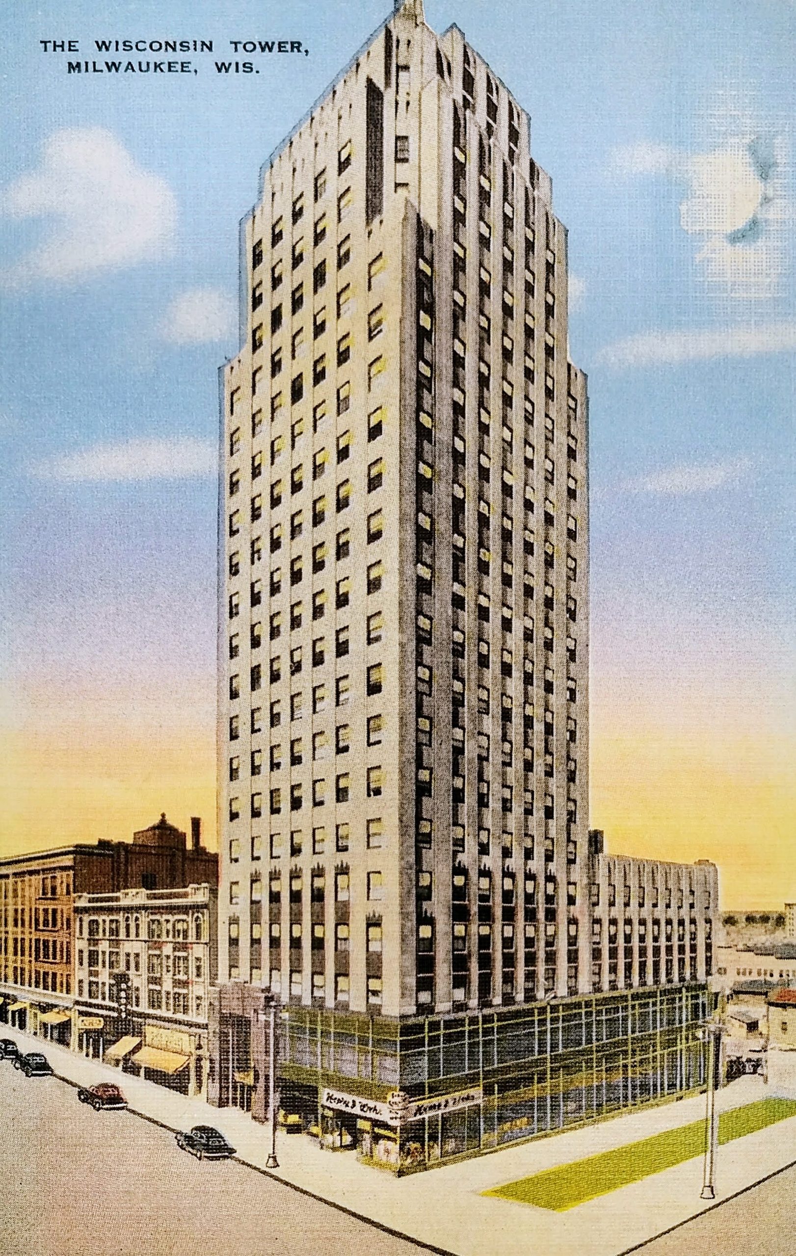
This undated postcard shows the Wisconsin Tower, originally known as the Mariner Building, which still stands on the northwest corner of 6th and Wisconsin.
The 22-story art-deco office tower was built in 1930. The original name came from the developer, John W. Mariner, who died a few months before the building was completed. Upon completion, it was the second tallest building in Milwaukee. The name changed to the Wisconsin Tower in 1939. The building was converted to condominiums in 2005.
Generations knew this building because the west side was used for large billboards that spanned many floors. Here is an early shot with several advertisements on the side of the building: https://www.wisconsinhistory.org/Records/Image/IM129061
You can’t see it in this postcard, but the building featured a 50-foot steel mast for a revolving beacon light and radio towers on the roof. There have been rumors that the tower was intended as mooring for blimps, but apparently there is no proof of this. The tower was originally enclosed in glass and used as an airplane beacon. You can see the tower enclosed in glass in this old photo on the MPL website: http://content.mpl.org/cdm/singleitem/collection/HstoricPho/id/1055/rec/16
The 4-story building to the left, Central Market Apartments, was built in 1918 with a grocery market on the first floor and apartments above. It still stands today.
And to the left of that are the Norman Apartments, built in 1888 and demolished by fire in 1991.
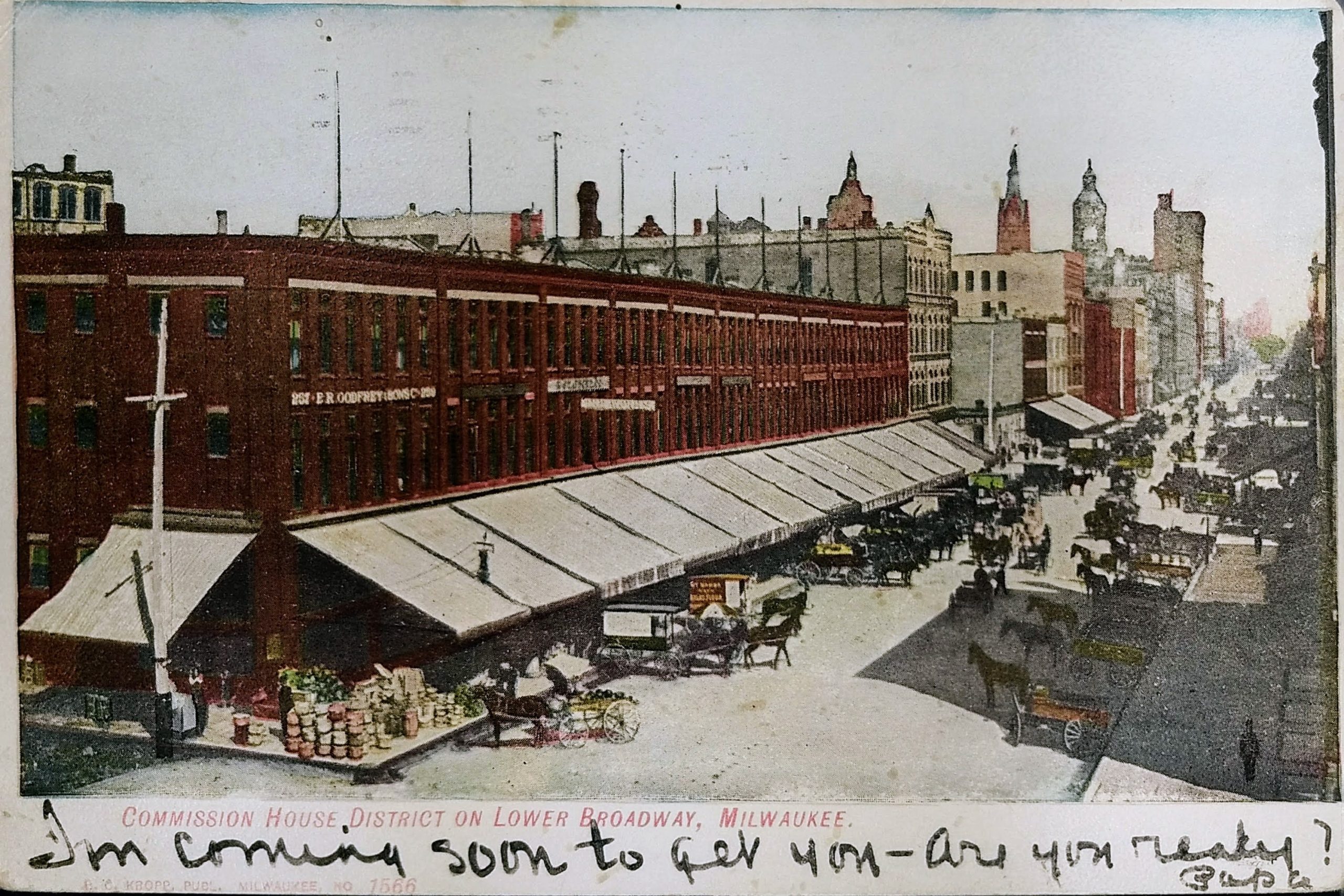
This postcard comes from near the early part of the last century. The postmark appears to be 1907 (and the rear has an undivided back entirely dedicated to the address, which was required by law prior to 1907.) Postcards of this era featured colorized photos, and you can see the original photo shown in this postcard on the Milwaukee Public Library site.
This view is of Broadway in the Third Ward. The perspective is looking NNW from what is now the Broadway Condominiums on the southeast corner of Broadway and Buffalo Streets. Four tall buildings are seen in the distance on the right half of the postcard. From left to right they are the Pabst Building (built in 1892), City Hall (built in 1895), the Chamber of Commerce Building (or Mackie Building) (built in 1880), and the Railway Exchange Building (built in 1901). Of the four tall structures seen towering in the distance, three still stand today in downtown Milwaukee.
The Third Ward was very important to Milwaukee’s early success. In 1856, when the first railroad from Milwaukee reached the Mississippi River, Milwaukee wholesalers did more business than those in Chicago because Milwaukee was 90 miles closer by steamship to the east coast. By the late 19th Century, the highest concentration of wholesalers in the city was located in the Third Ward due to its location adjacent to the harbor, rivers, and railroads. By the end of the century, as railways competed with Great Lakes shipping, trade would start shifting to Chicago due to the expansion of rail systems to the south.
The Third Ward District is listed on the National Register of Historic Places. The 1984 registration notes that seventy-one buildings are contained within the roughly-twelve-block boundaries of the historic district, almost all of which are multi-story warehouses or industrial structures built between 1892 and 1928.
That first date is important because 1892 is when the Third Ward suffered an enormous and destructive fire. On October 28, 1892, a fire fueled by strong winds of up to 50 mph spread throughout the Third Ward. A small fire started in the Union Oil Co. warehouse on the west side of Water Street, north of Buffalo. Although it was thought to have been quickly brought under control, a fire broke out in a neighboring factory (the Bub and Kipp factory, which was located where Commission Row is now) an hour later. Before morning, three firefighters were dead, two women had died of apparent shock, 215 railroad cars were consumed, and 81 large brick buildings and 359 wood-frame structures were destroyed. 1,900 people, mostly Irish families, were left without homes.
Following the fire in 1892, Milwaukee rapidly replaced the lost buildings. Although many of the buildings lost were residential, the redevelopment focused on warehouses to take advantage of the easy water and rail shipping lines; as a result, the population of the Third Ward never recovered to its pre-fire totals. Today, 30% of the buildings remaining in the area date from the 1890s rebuilding period, and 98% of all buildings remaining in the district were built before the Crash of 1929.
Commission Row, featured in this postcard, was built by the Ludington Estate in 1894-95. As noted, it was built on the site of the Bub and Kipp factory, which was the second building destroyed in the Third Ward fire.
Just to the north, you’ll see a four-story cream-colored building that abutts Commission row. That was one of the few Third Ward buildings that escaped destruction in the 1892 fire and is the oldest manufacturing building in the district. The Jewett & Sherman Co. mill was built in 1875. By the 1940s, it was used as a commission house, then for offices and a restaurant. Today, The Wicked Hop is housed in this building.
The block to the north of the Jewett & Sherman (between the Third Ward and downtown) has changed considerably. The old buildings you see in the postcard were razed in the 1960s to make way for the elevated I-794 freeway. Today, you’ll also find the Milwaukee Public Market on that block, with the area under the freeway used for parking.
On a personal note, this view has a special meaning for my wife and me. We owned a pet boutique, Metropawlis, that was housed in small portion on the north end of this building from 2005 to 2009.
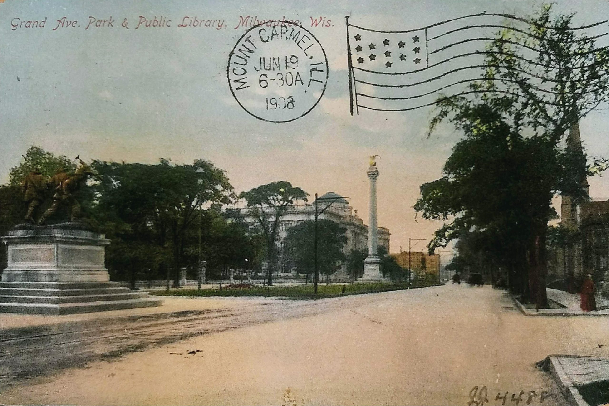
This postcard is postmarked 1908. It shows the scene looking east down what is now called Wisconsin Avenue from 10th Street. In the background, on the north side of the street, is the Milwaukee Public Library. It was opened in 1898. The Library shared the building with the Milwaukee Public Museum until the museum moved to its own building across Wells Street in the mid-1960s.
While the postcard is postmarked 1908, the photo likely predates 1903. The Saint James Court Apartments were built in 1903 and would be obvious beyond the church. Both the church and the apartments are on the National Register of Historic Places.
You can see three monuments in the middle of Grand/Wisconsin Avenue. The furthest one is very difficult to see–barely a dark smudge against a brown building–but that is Milwaukee’s oldest monument. The 3,000-pound, 10-foot tall statue of George Washington was presented to the city 1885 and was recently restored.
The tall monument in the center is called the Carnival Column with Sphere. This 65-foot Corinthian column commemorates the week-long carnival held in Milwaukee during the administration of Mayor David Rose. The eagle pictured atop the sphere was identical to those above the public library entrance.
And on the left is The Victorious Charge, an 1898 civil war monument. This bronze group of four soldiers, cast in Rome, is dedicated to “those who fought in the War for the Union.” When a local art patron failed to raise the needed funds for the monument, Captain Frederick Pabst paid the balance.
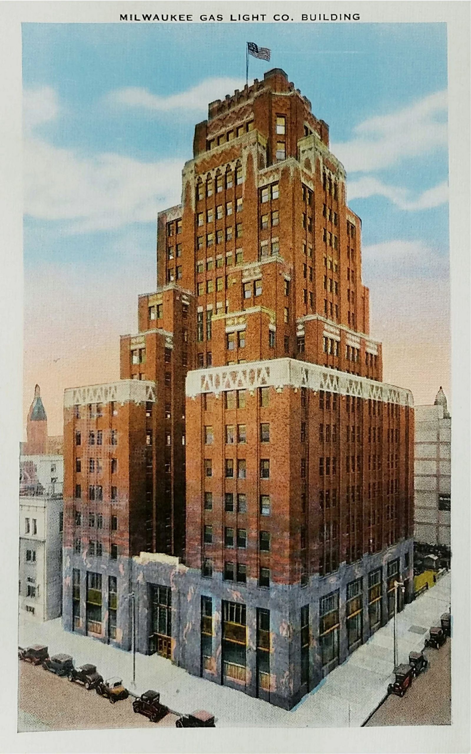
The building at 626 East Wisconsin Avenue has been known by a number of similar names. This postcard labels it Milwaukee Gas Light Building, but it’s also been known as the Wisconsin Gas Light Building, the Wisconsin Gas Building, and now as the Gas Light Building. In 2015, it was purchased for $20.5 million by M & J Wilkow, and as of 2020, the property management firm continues to own and lease out space in the office building.
The postcard isn’t postmarked, but it’s easy to get some idea of the postcard’s date. The iconic 21-foot flame atop of the building is missing, which means this postcard was published between 1930 when the building was completed and 1956 when the flame was constructed. based on the cars on the street, the postcard appears to be from the 30s, shortly after the building construction was completed.
The flame shares a simple weather forecast based on a rhyme that generations of Milwaukee children knew (albeit with several variations):
When the flame is red, it’s warm weather ahead. When the flame is gold, watch out for cold. When the flame is blue, there’s no change in view. When there’s a flickering flame, expect snow or rain!
Some erroneous reports indicate the flame was originally powered by gas, but it’s always been electric. It was built with neon and argon tubing and then converted to energy-efficient LED lighting. The flame has been in continual operation for over 60 years except for the period of 1978 to 1985 when it was darkened due to the energy crisis.
The building was designed by architects Eschweiler & Eschweiler to shift from dark granite at the base to red and pink brick in the midsection and cream color brick at the top.