Postcard: Wisconsin Avenue East from the River

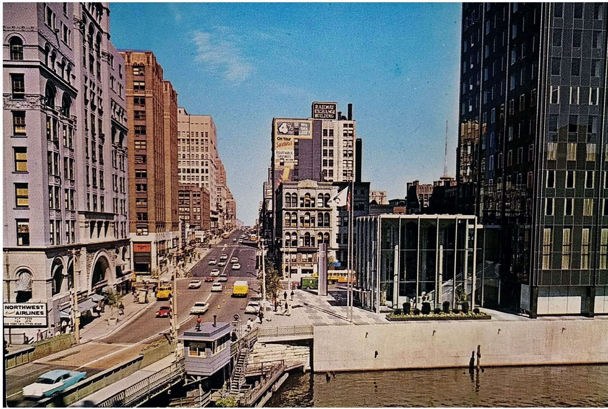
This undated postcard from the 1960s shows the view from the Gimbel’s building looking east down Wisconsin Avenue.

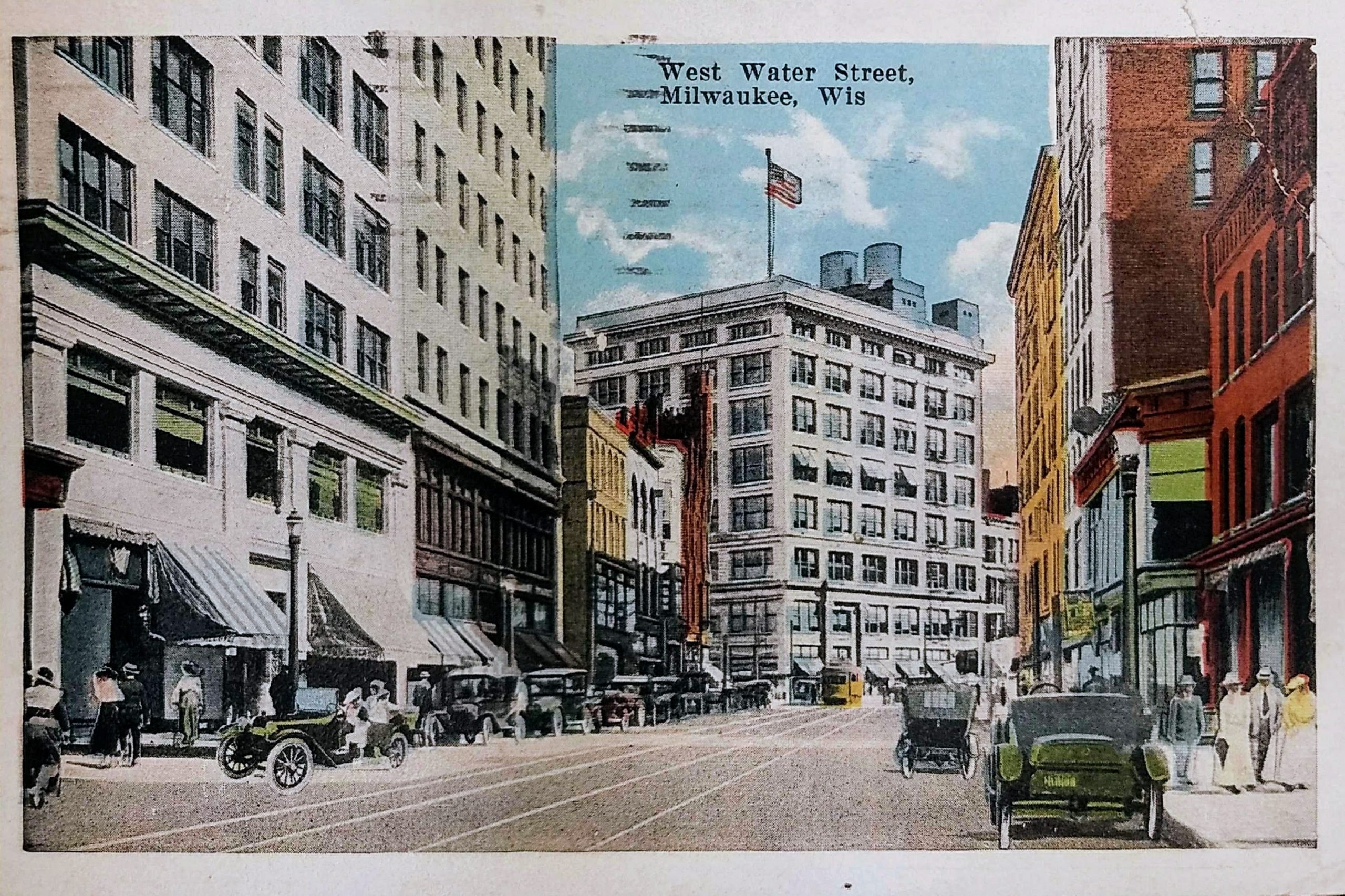
On the left in the foreground is the Pabst Building, Milwaukee’s first skyscraper, which was razed to make room for the 100 East Building. Demolition began in December 1980 and was done at night and on weekends to protect passersby.

By February 1981, much of the building was gone except for the beautiful entry archway you can see in this postcard. In a February 17, 1981 editorial entitled “Beauty vs. the Wrecking Ball,” the Milwaukee Journal made an appeal for donations to save and relocate the arch. Preservationists unsuccessfully attempted to raise enough money to salvage the arch, and eventually, the demolition company offered to remove it at no cost if it could be toppled without seriously damaging the historic archway. Unfortunately, on April 2, 1981, eighty-nine years after the Pabst Building’s archway first welcomed guests, it was destroyed when the salvage crew was unable to bring it down unharmed. “When the archway slammed down, it shook the whole East Side,” said the preservationist working with the wrecking crew.

Directly across the street from the Pabst Building, in the foreground on the right, is what was then the Marine Bank Building, now known as Chase Tower. It opened in 1961.

Behind the Marine, on the southeast corner of Wisconsin and Water Streets, is the Iron Block Building. Over the years, it was known as the Martin’s Block (after James Baynard Martin who built it) and the Excelsior Block or Masonic Hall (since the Excelsior Masonic Lodge had its meeting rooms on the top floor). It was built in 1861 and is Milwaukee’s only remaining cast-iron façade building. It was added to the National Register of Historic Places in 1974.

Behind the iron block on the south side of Wisconsin Ave, you can see the 12-story Railway Exchange Building, which also still stands today. It was built in 1901 and served as the headquarters of the Chicago and Northwestern Railway from 1901–1945. It was the work of William LeBaron Jenney, known worldwide as the “father of the skyscraper,” and is his only Milwaukee building.

Sources:

https://0-infoweb-newsbank-com.countycat.mcfls.org/apps/news/openurl?ctx_ver=z39.88-2004&rft_id=info%3Asid/infoweb.newsbank.com&svc_dat=WORLDNEWS&req_dat=0D8DE8DE83992E4A&rft_val_format=info%3Aofi/fmt%3Akev%3Amtx%3Actx&rft_dat=document_id%3Aimage%252Fv2%253A119BAA7547AD9B50%2540EANX-NB-16FB2880C2357E09%25402444591-16FB24B9B931B74E%25404-16FB24B9B931B74E%2540/hlterms%3A%2522Pabst%2520building%2522

https://0-infoweb-newsbank-com.countycat.mcfls.org/apps/news/openurl?ctx_ver=z39.88-2004&rft_id=info%3Asid/infoweb.newsbank.com&svc_dat=WORLDNEWS&req_dat=0D8DE8DE83992E4A&rft_val_format=info%3Aofi/fmt%3Akev%3Amtx%3Actx&rft_dat=document_id%3Aimage%252Fv2%253A1477BBDEA50EB75C%2540EANX-NB-16325D4CF7643D1D%25402444653-1631CDC6367B756D%25409-1631CDC6367B756D%2540/hlterms%3A%2522Pabst%2520building%2522

https://0-infoweb-newsbank-com.countycat.mcfls.org/apps/news/openurl?ctx_ver=z39.88-2004&rft_id=info%3Asid/infoweb.newsbank.com&svc_dat=WORLDNEWS&req_dat=0D8DE8DE83992E4A&rft_val_format=info%3Aofi/fmt%3Akev%3Amtx%3Actx&rft_dat=document_id%3Aimage%252Fv2%253A119BAA7547AD9B50%2540EANX-NB-16FB40727B2C3964%25402444697-16FB3100EC4600C0%25404-16FB3100EC4600C0%2540/hlterms%3A%2522Pabst%2520building%2522

https://www.wisconsinhistory.org/Records/Property/HI16292

https://en.wikipedia.org/wiki/Iron_Block_Building_(Milwaukee,_Wisconsin)

https://npgallery.nps.gov/NRHP/GetAsset/NRHP/74000105_text

https://onmilwaukee.com/history/articles/railwayexchange.html

Identifiers:

PLUS Code: 23QQ+CR Milwaukee, Wisconsin

Approximate Google Earth view today: https://earth.google.com/web/@43.03857055,-87.90895732,176.12857143a,110.73004225d,35y,84.60775985h,76.7466551t,0r/data=CiUaIxIdCgAZDi2yne-ERUAhVOOlm0T6VcAqBzIzUVErQ1IYASAB

Postcards: Milwaukee River, Looking North, Milwaukee, Wis. and Downtown View of Milwaukee River, Milwaukee, Wis.

These two postcards show the view of the Milwaukee River from about a block apart. The postcard on top was postmarked in 1936, and the view is north from the east side of the river on Clybourn Street. The second postcard is postmarked 1948, and it shows the view north from Michigan Ave.

On the left side of the river is the old Gimbels Department Store. This location opened in 1887, but this shot is of the building after 1923 when Gimbels tore down their building and rebuilt an eight-story structure. The building currently houses the American Society of Quality and a Residence Inn.

The tower on the right is the old Pabst Building which was built in 1892 and demolished in 1981. It was Milwaukee’s first skyscraper. That site is where the 100 East Wisconsin Building now stands, on the northwest corner of Wisconsin and Water Streets.

Just beyond that, with a tall sign on the side, is the First Wisconsin National Bank building. The bank remained there until it moved to its new 42-story tower on East Wisconsin Ave in 1973. This building, now known as the CityCenter, still stands on the southwest corner of Water and Mason Streets

The open lot on the left of the first postcard is the site of the Riverside Building, an office building perched awkwardly atop a parking garage. That building won’t be built for three decades at the time this shot was taken. In 2019, the building was redesigned for Rexnord.

In 1936, when the first postcard is dated, Mayor Dan Hoan appeared on the cover of Time Magazine. The magazine called Hoan “one of the nation’s ablest public servants, and, under him, Milwaukee has become perhaps the best-governed city in the U.S.” He was a socialist who’d been in office for 20 years. Milwaukee had managed to avoid the worst of the depression until 1932, and under Hoan, the city launched a number of work relief programs, built libraries and parks, and helped Milwaukee through the worst of the era.

If you study Milwaukee’s history and architecture, it’s easy to see the impact of the Great Depression and WWII in the 1930s and 1940s. While dozens of buildings were added to downtown in the first few decades of the 20th Century, relatively few were built from 1935 to 1950. Building picked up again in the late-1950s and exploded in the 1960s

Sources:

https://www.wisconsinhistory.org/Records/Property/HI16193

https://collections.lib.uwm.edu/digital/collection/mkenh/id/312/

http://www.wisconsinhistoricalmarkers.com/2015/09/historic-milwaukee-east-wisconsin-avenue.html

https://urbanmilwaukee.com/2019/09/13/friday-photos-rexnord-will-occupy-downtown-buildings/

https://shepherdexpress.com/news/happening-now/popular-appeal-milwaukee-s-legacy-sewer-socialists/#/questions

http://content.time.com/time/covers/0,16641,19360406,00.html

Identifier:

First postcard: PLUS Code: 23PR+F4 Milwaukee, Wisconsin

Second Postcard: PLUS Code: 23PR+X2 Milwaukee, Wisconsin

First postcard: Approximate Google Street View Today: https://goo.gl/maps/uKfVTC1o78Rne6Jn6

Second postcard: Approximate Google Street View Today: https://goo.gl/maps/NMhcKJtdsUmsuEL78

Postcard: West Water Street, Milwaukee, Wis

This postcard is postmarked 1923 and is labeled West Water Street. Around a decade after this postcard was sent, Milwaukee would rename the street as North Plankinton Avenue, which is how we know it today.

This view is facing south toward Wisconsin Avenue (which, as of the postmark date, would have been named Grand Avenue). In the center is the Gimbels Building. Adam Gimbel first opened a shop in Vincennes, Indiana in 1842. He and his seven sons (the Gimbel Brothers) eventually relocated to Milwaukee in 1887, renting space from John Plankinton on the corner you see here. The retail operation rapidly expanded into adjoining buildings, and in 1902, Gimbel demolished the original three-story building on the southeast corner of Water and Grand (now Plankinton and Wisconsin) and built the eight-story structure you see in this postcard. This Gimbel building, designed by D.H. Burnham and Co. of Chicago, was the first of many adjoining structures that the Gimbel Brothers would build in the following decades to expand into the entire block along the river from Wisconsin Avenue to Michigan Avenue.

On the near corner on the left, across Wisconsin Avenue from Gimbels, the Empire Building (containing the Riverside Theater) would be built five years after this postcard was sent. The much smaller building you can see in this postcard on the corner was also known as the Empire Building, and it was built around 1898. This building featured the Empire Café on the corner of the ground floor. It was also known as the Browning Building from 1921 until 1927, when it was razed to make way for the current Empire Building and Riverside Theater.

The white building on the far left is now the Riverfront Lofts. Built in 1916, the building was a furniture store and warehouse for Waldheims and Nelson Brothers over the years.

Sources:

https://www.wisconsinhistory.org/Records/Property/HI16193

https://www.wisconsinhistory.org/Records/Property/HI41778

https://www.wisconsinhistory.org/Records/Image/IM47664

Milwaukee Journal, May 8, 1979: https://0-infoweb-newsbank-com.countycat.mcfls.org/apps/news/openurl?ctx_ver=z39.88-2004&rft_id=info%3Asid/infoweb.newsbank.com&svc_dat=WORLDNEWS&req_dat=0D8DE8DE83992E4A&rft_val_format=info%3Aofi/fmt%3Akev%3Amtx%3Actx&rft_dat=document_id%3Aimage%252Fv2%253A1477BBDEA50EB75C%2540EANX-NB-156E03CD64C6200B%25402444002-156E02A9922028A3%2540130-156E02A9922028A3%2540/hlterms%3A%2522Browning%2520Building%2522

Milwaukee Journal Sentinel, June 19, 1997: https://0-infoweb-newsbank-com.countycat.mcfls.org/apps/news/openurl?ctx_ver=z39.88-2004&rft_id=info%3Asid/infoweb.newsbank.com&svc_dat=WORLDNEWS&req_dat=0D8DE8DE83992E4A&rft_val_format=info%3Aofi/fmt%3Akev%3Amtx%3Actx&rft_dat=document_id%3Anews%252F0EB82ABB00487972

Identifiers:

PLUS code: 23QQ+Q7 Milwaukee, Wisconsin

Approximate Google Street View today: https://goo.gl/maps/HSCZKTDiGqwZekFm8

Postcard: Grand Ave. Park & Public Library, Milwaukee, Wis.

This postcard is postmarked 1908. It shows the scene looking east down what is now called Wisconsin Avenue from 10th Street. In the background, on the north side of the street, is the Milwaukee Public Library. It was opened in 1898. The Library shared the building with the Milwaukee Public Museum until the museum moved to its own building across Wells Street in the mid-1960s.

The church on the right still stands. St. James’ Episcopal Church was built in 1867. It closed its doors in November 2017 and was sold. The new owners have opened a wedding and events venue in the building.

While the postcard is postmarked 1908, the photo likely predates 1903. The Saint James Court Apartments were built in 1903 and would be obvious beyond the church. Both the church and the apartments are on the National Register of Historic Places.

You can see three monuments in the middle of Grand/Wisconsin Avenue. The furthest one is very difficult to see–barely a dark smudge against a brown building–but that is Milwaukee’s oldest monument. The 3,000-pound, 10-foot tall statue of George Washington was presented to the city 1885 and was recently restored.

The tall monument in the center is called the Carnival Column with Sphere. This 65-foot Corinthian column commemorates the week-long carnival held in Milwaukee during the administration of Mayor David Rose. The eagle pictured atop the sphere was identical to those above the public library entrance.

And on the left is The Victorious Charge, an 1898 civil war monument. This bronze group of four soldiers, cast in Rome, is dedicated to “those who fought in the War for the Union.” When a local art patron failed to raise the needed funds for the monument, Captain Frederick Pabst paid the balance.

Sources:

https://en.wikipedia.org/wiki/Milwaukee_Public_Library

https://www.wisconsinhistory.org/Records/Property/HI27620

https://onmilwaukee.com/history/articles/stjamesspelunking.html

https://npgallery.nps.gov/NRHP/AssetDetail?assetID=9d02251f-4c0c-464b-944c-27c868350047

https://npgallery.nps.gov/NRHP/AssetDetail?assetID=5b89dc04-a088-446b-81db-2751d0a1426b

https://en.wikipedia.org/wiki/Washington_Monument_(Milwaukee)

https://www.tmj4.com/news/local-news/newly-restored-george-washington-monument-back-on-display-in-downtown-milwaukee

http://www.wisconsinhistoricalmarkers.com/2015/06/historic-milwaukee-west-wisconsin-avenue_6.html

https://onmilwaukee.com/history/articles/courtofhonor.html

https://en.wikipedia.org/wiki/The_Victorious_Charge

Identifiers:

PLUS Code: 23QG+C5 Milwaukee, Wisconsin

Approximate Google Street View Today: https://goo.gl/maps/LAXKmDx6zhZsW4ya6

Postcard: Bird’s-eye View, Northeast from Union Depot, Milwaukee, Wis.

The postmark on this postcard is 1928. This shot is a view looking northeast from Union Station (also known as Everett Street Station and Milwaukee Union Depot). The station opened in 1886, was replaced by the Milwaukee Intermodal Station (the Amtrak station on St. Paul Avenue) in 1965, and was razed the next year following a fire that damaged the building.

Today, you will find the WE Energies annex building where Union Station once stood. It is on Everett Street, between 2nd Street and Vel R. Phillips Avenue/4th Street. The street is parallel to Michigan Avenue, which you can see running left to right in the foreground of this image. The station faced the Fourth Ward Park (now known as Zeidler Park), seen at the bottom of the postcard.

Several of the buildings in this shot still stand. The stately white and cream building on the right is the Milwaukee Interurban Terminal, which was opened in 1905 by The Milwaukee Electric Railway and Light Company. At the time, it was the largest terminal of its kind in the United States. Today, that building is the WE Energies headquarters at 231 W Michigan Steet.

The white building standing tall in the center also still exists and is attached to what was the Grand Avenue Mall. The Majestic Building was built in 1907 by the Schlitz Brewing Company. It once housed the Majestic, the second-largest vaudeville theater downtown. After hosting acts including the Marx Brothers, Eddie Cantor, Jack Benny, Fanny Brice, and George M. Cohan, the Majestic closed in 1932. The building today houses the Majestic Loft Apartments.

And to the left, the tall, red building with the peaked gable roof and flag also still stands. It is the former Hotel Wisconsin, which opened in 1913. Many famous people visited the Hotel Wisconsin, including first lady Eleanor Roosevelt and comedy duo Laurel & Hardy. In the 1990s, a favorite restaurant of mine, Cafe Melange, was on the first floor. Today the building is The Grand Wisconsin apartments.

The middle flag sits atop the Milwaukee City Hall in the distance.

The buildings in the foreground are all gone–this is where the Courtyard Marriott now stands.

Sources:

https://en.wikipedia.org/wiki/Everett_Street_Depot

http://www.wisconsinhistoricalmarkers.com/2012/08/marker-234-milwaukee-interurban-terminal.html

https://www.wisconsinhistory.org/Records/Property/HI41861

http://www.wisconsinhistoricalmarkers.com/2014/10/historic-milwaukee-west-wisconsin-avenue.html

https://onmilwaukee.com/visitors/articles/urban-spelunking-hotel-wisconsin.html

Identifiers:

PLUS Codes: 23PM+HV Milwaukee, Wisconsin

Approximate Google Earth view today: https://earth.google.com/web/@43.03753846,-87.91476257,190.93950686a,85.55386167d,35y,23.49206988h,82.90810522t,0r

Postcard: Wisconsin Street, looking East from Post Office, Milwaukee

This postcard calls the street (running from the foreground to the lake in the background) Wisconsin Street. Prior to 1926, this street had two different names–Grand Avenue west of the Milwaukee River and Wisconsin Street east. In 1926, the city renamed the entire length as Wisconsin Avenue.

The postcard isn’t dated but comes from the early years of the 20th Century. We can tell this because the scene is from the perspective of the tower of the Federal Building, which was built in 1899 between Jackson and Jefferson Street on Wisconsin Avenue. The most prominent intersection, in the lower right corner, is Wisconsin and Van Buren, which today is dominated by three familiar buildings: The Gas Light Building (1930) on the near left corner, the Northwestern Mutual building (1914) on the far left, and the US Bank tower (1973) on the far right. (Also, the rear of this postcard has the sort of familiar divided back we know today–with a section on the left for a handwritten note and another section on the right for the address–and those postcards weren’t permitted in the US until 1907.)

This section of Milwaukee’s downtown saw considerable change as the “city” grew eastward from its origins on the river. The many residential homes and small apartment buildings that you see on the left (north) would be replaced by commercial and midrise apartment buildings in the next several decades.

On the right (or south side of Wisconsin Avenue), you can see a number of historic old buildings that were subsequently demolished. The tall tower in the distance is the Chicago & Northwestern Lake Front Depot (built in 1890 and razed in 1968). The circular turret in front of that is the Globe Hotel (built in 1892 and razed in 1961), which was on the southeast corner of Wisconsin and Cass. And the large red building on the right edge of the postcard was the Hotel Martin (built in 1889 and razed in 1958).

The shore of Lake Michigan was a lot closer to the city at the time of this postcard than it is today. Lake and Veteran Parks were created from landfill over the course of decades, expanding the city’s footprint into Lake Michigan.

Sources:

https://emke.uwm.edu/entry/grand-avenue/

Identifiers:

PLUS Code: 23QW+C4 Milwaukee, Wisconsin

Approximate Google Earth view today: https://earth.google.com/web/@43.03920584,-87.90256499,184.8871059a,166.93667098d,35y,70.8383103h,74.43074418t,0r

Postcard: Milwaukee Gas Light Co. Building

The building at 626 East Wisconsin Avenue has been known by a number of similar names. This postcard labels it Milwaukee Gas Light Building, but it’s also been known as the Wisconsin Gas Light Building, the Wisconsin Gas Building, and now as the Gas Light Building. In 2015, it was purchased for $20.5 million by M & J Wilkow, and as of 2020, the property management firm continues to own and lease out space in the office building.

The postcard isn’t postmarked, but it’s easy to get some idea of the postcard’s date. The iconic 21-foot flame atop of the building is missing, which means this postcard was published between 1930 when the building was completed and 1956 when the flame was constructed. based on the cars on the street, the postcard appears to be from the 30s, shortly after the building construction was completed.

The flame shares a simple weather forecast based on a rhyme that generations of Milwaukee children knew (albeit with several variations):

When the flame is red, it’s warm weather ahead.
When the flame is gold, watch out for cold.
When the flame is blue, there’s no change in view.
When there’s a flickering flame, expect snow or rain!

Some erroneous reports indicate the flame was originally powered by gas, but it’s always been electric. It was built with neon and argon tubing and then converted to energy-efficient LED lighting. The flame has been in continual operation for over 60 years except for the period of 1978 to 1985 when it was darkened due to the energy crisis.

The building was designed by architects Eschweiler & Eschweiler to shift from dark granite at the base to red and pink brick in the midsection and cream color brick at the top.

Sources:

http://oldmilwaukee.net/detail-history-form.php?id=481

https://www.wisconsinhistory.org/Records/Property/HI16199

https://www.wilkow.com/portfolio/gas-light-building

https://en.wikipedia.org/wiki/Wisconsin_Gas_Building

https://www.emporis.com/buildings/122443/wisconsin-gas-building-milwaukee-wi-usa

https://emke.uwm.edu/entry/wisconsin-gas-building/

https://www.wuwm.com/post/update-story-behind-flame-wisconsin-avenue#stream/0

https://www.bizjournals.com/milwaukee/blog/real_estate/2015/04/gas-light-building-in-downtown-milwaukee-sold-for.html

Identifiers:

EBN 122443

AHI 16199

OldMilwaukee.net 481

PLUS Code: 23QW+JP Milwaukee, Wisconsin

Approximate Google Street View: https://goo.gl/maps/dBuxJAUyFtZTJem16