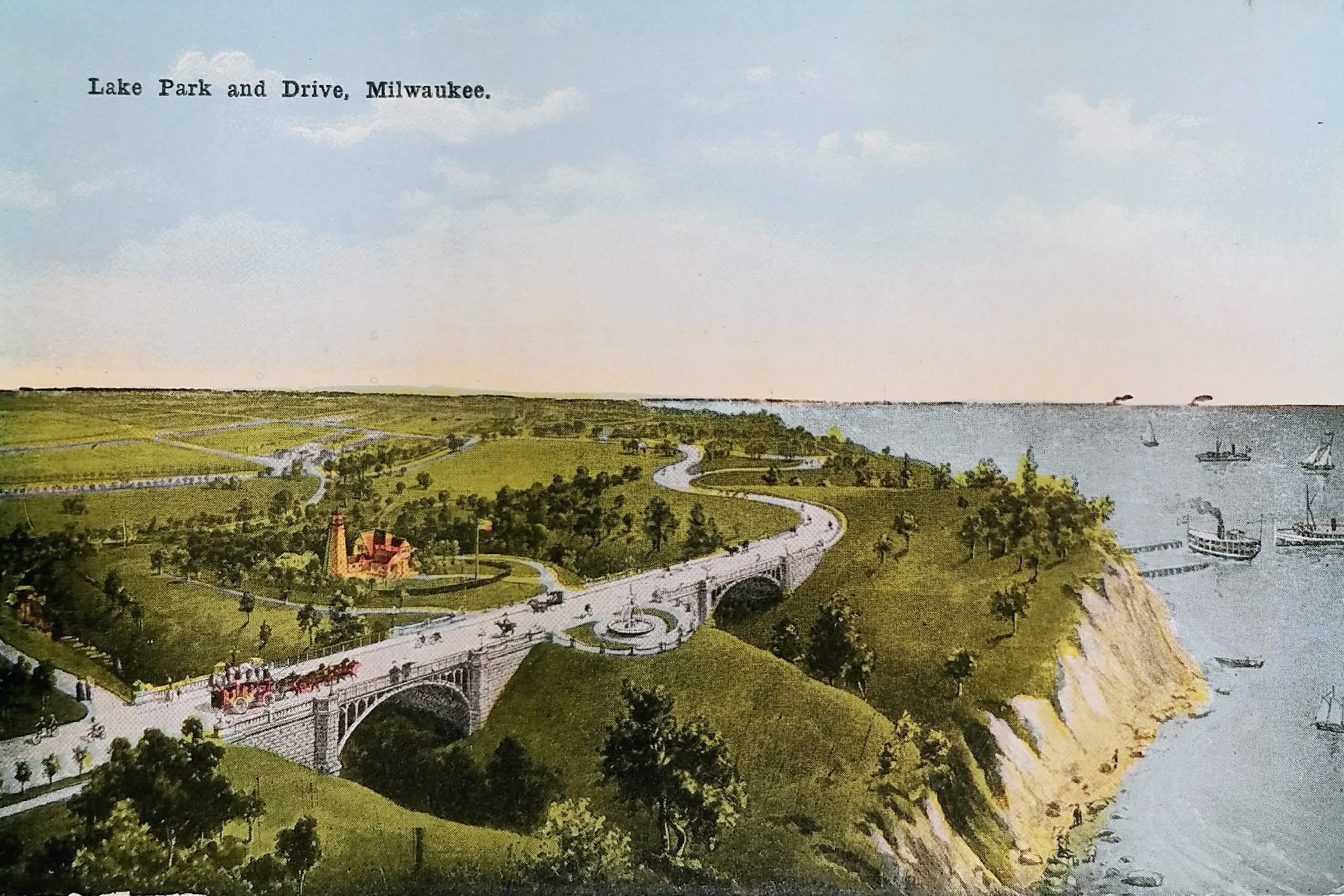
Today’s Lake Park is hardly recognizable in this postcard. It’s difficult to imagine the park with so few trees, isn’t it? This image depicts the park around 1900, after the Lion Bridges were complete but before other park facilities were added in the first decade of the 20th century.
The roadway pictured on the left portion of the postcard is now a pedestrian trail called the Oak Leaf Trail. The road in the upper right portion is today the Lake Park Road that leads to the Lake Park Bistro parking lot. The two “Lion Bridges” on either side of the lighthouse were constructed in 1896-97. In 1964, the bridges were narrowed and closed to vehicles. Today, that fountain between the bridges is gone, but you can still see the semicircular chain fence that remains.
The lighthouse is the North Point Lighthouse. The original lighthouse was built in 1855 but had to be abandoned because of bluff erosion. This lighthouse was built 100 feet further inland and began use in 1888. In 1907, the lighthouse began operating locally after Congress ceased funding due to trees and city lights obscuring the beacon.
The image shows the lighthouse at its 1888 height of 39 feet. In 1912, a new steel structure with the old iron tower attached on top raised the beacon to 74 feet from the ground. That is the lighthouse you can visit today. The U.S. Coast Guard decommissioned it in 1994.
Although the postcard is undated, it has a divided back, which means it was printed after 1907, but the image seems to reflect how Lake Park looked roughly a decade earlier. There are no trees growing to obscure the lighthouse. Also, by 1899, a horse barn (not pictured) was opened. In 1903 a 6-hole golf course was created just north of the lighthouse (also not pictured) and the pavilion (which today houses Lake Park Bistro) opened beyond that first bend of the roadway. Lake Park’s famous grand staircase, leading from landfill at the shore to the pavilion would come later, in 1908.
Lake Park was designed by Frederick Law Olmsted. He was the landscape architect responsible for Central Park in New York City and the grounds of Chicago’s Columbia Exposition.
At the time of this postcard, the bluff fell directly into the lake. Since then, landfill has been used to extend the shore for Lincoln Memorial Drive and the parks on Milwaukee’s lakeshore.
Roughly where those ships rest at the dock is where the Milwaukee Gun Club once had a shooting range on land created by the landfill. The gun club received a license for the land in 1928, but for five decades the county fought to evict the club, seeking to use the space for general park activity. The club agreed to move, then renigged on the promise, and finally went to court to try to keep the land. In 1992, after losing their case, the gun club finally agreed to abandon the site. Today, a rugby field is located approximately at this spot along the lakefront.
Sources:
http://lakeparkfriends.org/history/map/
https://bridgehunter.com/wi/milwaukee/bh36758/
Identifiers:
PLUS Code for North Point lighthouse: 348H+7C Milwaukee, Wisconsin
Approximate Google Earth view today: https://earth.google.com/web/@43.06667998,-87.86961156,215.67551459a,406.4992602d,35y,27.93091114h,86.94008376t,360r