I imagine we have all done it. Found a tantalizing tidbit on a subject and decided to research it further. It sounds so exciting and newsworthy. Just find what there is to be found and put it into an article. Heck, maybe even a short book. There will be so much of interest. The big problem will be what to use and what to discard. The research starts for real. And then……almost nothing on the subject everywhere you look. You have to word spin just to get to the middle of page two.
While not quite as bad as that, my project on Milwaukee’s first Black baseball organizer and star player–Napoleon Broady and his Milwaukee Reds–yielded some information, but left what I suspect is a lot of baseball unreported and probably lost to time.
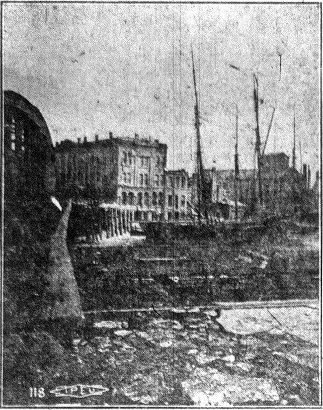
The Reds (originally named Red Stockings) were first organized in May 1890, consisting of "the culinary and bell hopping department of the Plankinton House”*, a large hotel on West Wisconsin Avenue at North 2nd Street. All the athletes looking for spots were "colored." The players chosen for the squad were:
Billy Johnson — 1b
Ben Underwood–2b
Napoleon Broady-3b
Spencer Butler-ss
Bill Lyons-rf
F.J. Chapman-cf
Bud Demly-lf
Randall Philips-c
Burt Hutchinson-p
The players held a meeting on May 7 and decided they were prepared to meet any amateur club in the city. "In order that no suspicions of partiality in umpiring should be raised”, the Reds decided to employ a man from another hotel as their umpire–"Jake", the Kirby House [on East Mason and North Water Streets] supernumerary. Challenges were to be addressed to James Blaine, superintendent of the bootblacking department of the Kirby House.
[* = The report the players consisted of "the culinary and bell hopping department of the Plankinton House" can be questioned. As will be seen below, Napoleon Broady worked at the Kirby house. Strangely, challenges were to be sent to James Blaine, who was a superintendent at the Kirby House. Others, Hutchinson and Phillips for example, never appear in City of Milwaukee directories I checked in the early to mid-1890s.]
The Plankinton House Reds first game was played a few days after their meeting. At Athletic Park, 7th and Chambers, home of the Western Association Brewers, the Reds beat the Lime Kiln Club—the only other Black baseball team organized in the city—by a score of 4 to 2. I could find no further information on the Lime Kilns before or after this game.
The Reds next game was on Sunday, June 8, again at Athletic Park. This game was against the Milwaukee Blues, a white team. It was reported the Reds had not had enough practice to get in "good trim" but would make things interesting for the Blues. The Reds and Blues both must have made the game interesting, the Reds winning 25 to 21. I could find no reports of any other games the Reds were to play during 1890.
Again in 1891 nothing could be found about the Milwaukee Reds baseball team. However, it was reported the following year the team won a number of victories in 1891, principally out of the state.
In 1892 the team emerged again. On June 2 the Milwaukee Journal announced the Plankinton House Nine had been organized as follows:
Nap Broady-captain and 3b
Eliott-1b
Harrison-2b
Ellis-ss
Demley-rf
Chapman-cf
Payn-p
Johnson-c
Sunday-lf
It was stated all communications should be addressed to Napoleon Broady, Kirby House.
The first game I could find in 1892 played by the Milwaukee Reds was against South Milwaukee on June 25. In that southern suburb of Milwaukee’s park, the Reds lost 4 to 2, in what was said to be a "close and exciting struggle." The teams met again a week later at Athletic Park, the South Milwaukees beating the Reds badly, 25 to 5.
In July the first game involving two teams of all-Black players was scheduled for Athletic Park. The Reds were to take on the Boston Dips, captained by Randall Phillips. Although sounding as if they were from the Massachusetts city, the Dips were from Milwaukee. It was reported a bitter rivalry existed between the teams, and the Milwaukee Sentinel stated "a wad of money as big as a pillow will be wagered before the game comes off." As can be seen above, pitcher Phillips was on the 1890 Reds with Broady, as was the Dips’ catcher, Burt Hutchinson. Both these players had played for the famous Gordons of Chicago. However, all the players of both nines could "play ball in dead earnest.”
I could only find the two games between the Reds and the South Milwaukee club mentioned above having been played by either the Reds or Dips in 1892. How many unreported games were played I can not guess, as the July 24 Sentinel stated "both clubs are fully uniformed and have been playing winning ball this season." However, in the same article the Sentinel reported this season the Reds had played only a few games, the best being the first of the South Milwaukee contests.
A few days before the game betting was said to be even on the teams, and demand for tickets was high. It was reported this game was the only topic of conversation in sporting circles. This might not be an exaggeration, as only a few weeks before the Milwaukee entry in the Western League had dropped from the league and the Western League disbanded very shortly after that. Tickets were put on sale at the Plankinton House drug store, Phil Lederer’s cigar store on Wisconsin Avenue, Rudolph Giljohan’s tavern on North Water Street, and the baseball headquarters. Anticipating a large crowd, arrangements were made to insure ample streetcar accommodations to and from the park. The day before the game Frank Brady, of the Southern Texas League, was agreed upon as umpire.
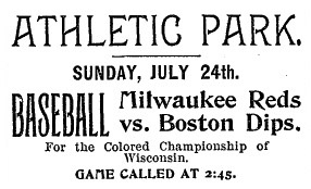
Milwaukee Journal July 22, 1892
At 1:30 p.m. Broady’s Reds left the Plankinton House on 2nd and Wisconsin Avenue in full uniform in carriages. Randall’s Dips left at the same time from North Third Street, between West Wells and Grand Avenue. Both teams paraded through downtown streets on the way to the ball park at 7th and Chambers, a distance of about 3 miles.
Napoleon Broady was reported to be 28 years old in a November 1895 newspaper article, making him born ca. 1867. In the 1880 U.S. census I found a Napoleon Broady, born 1868 in Ohio. At the time of the census he was living in Miami, Ohio. If this is the same person, I could not find when he came to Milwaukee, when/if he left Milwaukee, or when he died.
A Napoleon Brody [sic] is first listed in the City of Milwaukee directories in 1890 as a porter at the Kirby House. Napoleon Brody is listed as this also in 1891 and 1892. In 1893 his name is spelled Brodie, but he is still listed as a porter at the Kirby House, possibly living there. His name is spelled Brodie again in the 1894 directory, but he is now listed as a bellboy–no hotel stated– and a home residence of 416 State is given. In 1895 Brodie’s occupation is given as waiter, with a residence of 413 Cedar. In the 1896 directory the name is again Napoleon Brody, and he is again a porter (again no hotel stated), living at 417 State. He is listed in the City of Milwaukee directory in 1897, again as a porter, living at 710 Wells. Starting in 1898 the name is almost always spelled Broady [the exception being 1904, when it is again spelled Brody.] In the next 19 years Napoleon is listed as a boot-black, porter, laundry man and bartender in the directories, living at a variety of near west side addresses. In the 1912 and 1913 directories he is listed as the owner of a saloon at 405 Cedar [West Kilbourn Avenue].
As can be seen Napoleon’s last name was spelled three different ways in city directories and local newspapers: Broady, Brody or Brodie.
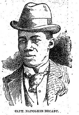
Milwaukee Sentinel July 24, 1892
Outside of baseball I first came across Napoleon Broady in local newspapers in May 1890 when he was used, unwittingly, in an attempted land scheme by some out of state men. (The Milwaukee Sentinel gives his name as Napoleon Brody, while he is referred to as James Broady in the Milwaukee Journal, adding another variant to the name). In January 1893 Broady was again in the newspaper, being involved in a shooting of a chambermaid at the Kirby House. The Sentinel identified him as Napoleon Broady, but the Journal gave his name as Alexander Broady, to add another name to the growing list. Napoleon was released from custody, as the shooting was determined to be accidental.
Little could be found on Napoleon Broady the baseball player. The July 24, 1892, Sentinel reported he had played baseball for the last ten years, “and at one time was a member of an amateur club of white players which defeated everything in and about Milwaukee.” [I do not remember coming across his name in my earlier research on Milwaukee’s amateur clubs of this period, and a quick check of the few box scores and accounts I have with player’s names of the major amateur clubs in the city, did not show his name. Perhaps further research, or that lucky find, will discover what team he played for, and when.] Broady’s baseball coaching style appears to have been vocal and colorful. The Sentinel commented: "when he gets out on the line he just ‘conversations’ his men around the bases and razzleates the pitcher." The newspaper said he would be at his best for this game against the Dips.
The game on July 24, 1892, itself was an exciting, close game, played in front of 1,500 to 2,000 people, who sat "in a sweltering sun." The Sentinel reported there were many "pretty plays" by members of both teams. Unfortunately, the game was called after seven innings, so that there would be plenty of time for the other contests. The Dips won by a score of 9 to 8.
Unfortunately, the newspaper coverage gave more attention to the non-baseball activities than the game itself. In respect to people I respect, I will not get into this aspect of the afternoon. One shorter paragraph was given to the game. But we can be thankful for the box score.
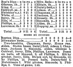
Milwaukee Sentinel July 25, 1892
I found no further games played by the Milwaukee Reds or the Boston Dips in 1892.
On July 10, 1893, the Reds played the Dips at Milwaukee’s National Park (South 27th Street and West National Avenue), the Reds winning 8 to 7. The Reds captain stated he was accepting any challenges, and they should be addressed to "Napoleon Brody, second porter, Kirby House.” Again, I could find no other game by either team played in 1893.
In 1894 the Reds, "whose members have in past years covered themselves with glory on the diamond field" where looking to again field a team. Milwaukee had a club in the minor Western League, but the team was in last place with a 10 and 25 record on June 20. On this day Broady talked to a Milwaukee Sentinel reporter. Napoleon told the reporter the Reds were in the "pink of condition" and were itching for a game. They decided to issue a challenge, and not to the all-Black teams of the area, but to Charlie Cushman’s Milwaukee Brewers. Saying the Brewers had been easier to beat than "makin’ a natural in a crap game,” the Red’s Captain said his team would play them for any amount of money. The Milwaukee Journal reported: "The Reds have the reputation of being an unusually strong team, capable of putting up a rattling game, so that it is somewhat surprising that Capt. Broady should stoop to meet the has-beens on the diamond.” Cushman and his Brewers were in Sioux City, Iowa, at the time, and Cushman was asked about the challenge. He said he would have to communicate with the board of directors about a game with the Reds, and "if a game is arranged, I have the utmost confidence as to the outcome." A game never came about.
The Milwaukee Reds did play at least one game in 1894. It was announced in the Sentinel as part of the events at the Turf Club picnic to be held at National Park on August 8, the Reds would play the Turf Club team. However, the Evening Wisconsin had earlier reported the Reds would play the Boston Dips on this day "for the colored championship of the state." Whatever teams played on August 8, I could find no results of any game.
Although Napoleon Broady’s name would appear in the newspapers a few times in the following years, I could find not a connection with him and baseball again. The last mention of him in the newspapers was on June 19, 1916, when it was reported Napoleon Brodie, was fined $25 and costs for being the “alleged keeper of a disorderly house.” The last City of Milwaukee directory Napoleon Broady (by any spelling of the name) appeared in was the 1916 directory.
At least for now I have lost the trail of Napoleon Broady after 1916. But hopefully more will be found on one of the first in Milwaukee’s tradition of local Black athletes and coaches.
Dennis Pajot, Milwaukee
(Originally posted on December 2, 2009)
Sources:
1880 United States Census
City of Milwaukee Directories 1890 to 1916
Milwaukee Sentinel May 8, 22, June 5, 8, 1890; June 26, 30, July 3, 17, 20, 23, 24, 25, 1892; January 16, July 11, 1893; June 21, August 5, 1894
Milwaukee Journal May 8, 21, June 5, 1890; June 2, July 16, 23, 25, 1892; January 16, 1893; June 21, 1894; November 11, 1895; June 19, 1916
Evening Wisconsin May 12, June 9, 1890; July 25, 1892; July 11, 1894
Milwaukee Daily News July 25, 1892


