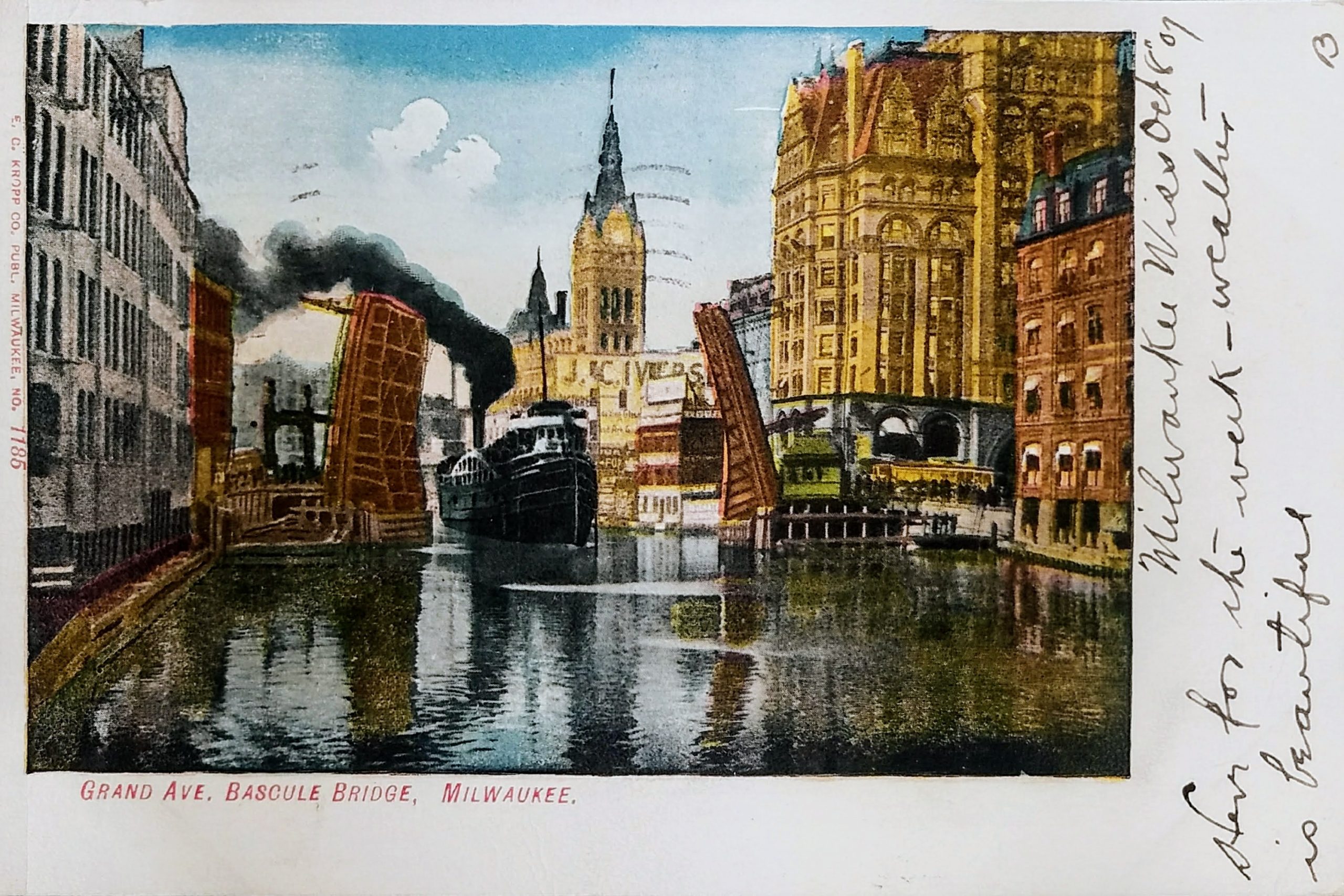
This postcard, postmarked 1907, shows a boat passing the Grand Avenue (now Wisconsin Avenue) Bascule bridge. (A bascule bridge is just a fancy name for a drawbridge).
This bridge would have been fairly new at the time this image was captured. A swing bridge, which pivoted horizontally from a piling in the center of the river, was replaced with this bridge in 1902. The old swing bridge was moved six blocks north to Chestnut Street, which is now called Juneau Avenue. In 1901, the city received four bids to build this bridge, ranging from $84,700 to $103,486 for an “ornamental structure.” (Those figures would be equal to $2.5M to $3.1M today.)
Just over the bow of the ship, you can see the J. C. Iversen building. John C. Iversen established his picture-framing business in 1867 on Spring Street (later Grand Avenue). The business prospered and expanded in 1879 to this five-story building you see here on E. Water Street (now N. Water Street).
On the left, you see the old four-story Gimbel’s building that was razed to make way for the new eight-story building in the 1920s. (At the top, you can see the last two letters of the Gimbel’s name.)
Postmarked 1940, this postcard shows the Milwaukee River looking south from the Wells Street Bridge.
On the far left is the 8-story Manufacturers Home Building, built in 1909. It was converted to apartments in 1997 and is currently known as “City Hall Square.” This building was home to the Central Continuation School, which eventually evolved into the Milwaukee Area Technical College. A 1919 publication noted that the school for girls was located here and could accommodate “about 5000 girls.” In the 1920s, the school moved to new facilities on 6th and State Streets where MATC is still located today.
Across Mason Street is the 16-story First Wisconsin National Bank, built in 1914. The building was home for the First Wisconsin Bank until the 42-story tower opened on East Wisconsin Ave in 1973.
The four-story neo-classic building nest to that is Marshall & Ilsley Bank, built in 1913. An additional two stories were added in 1930. The building was demolished in 1981 to make room for the 100 East Wisconsin building.
South of that, on Wisconsin Ave, is Milwaukee’s first skyscraper, the Pabst Building (1892 to 1981).
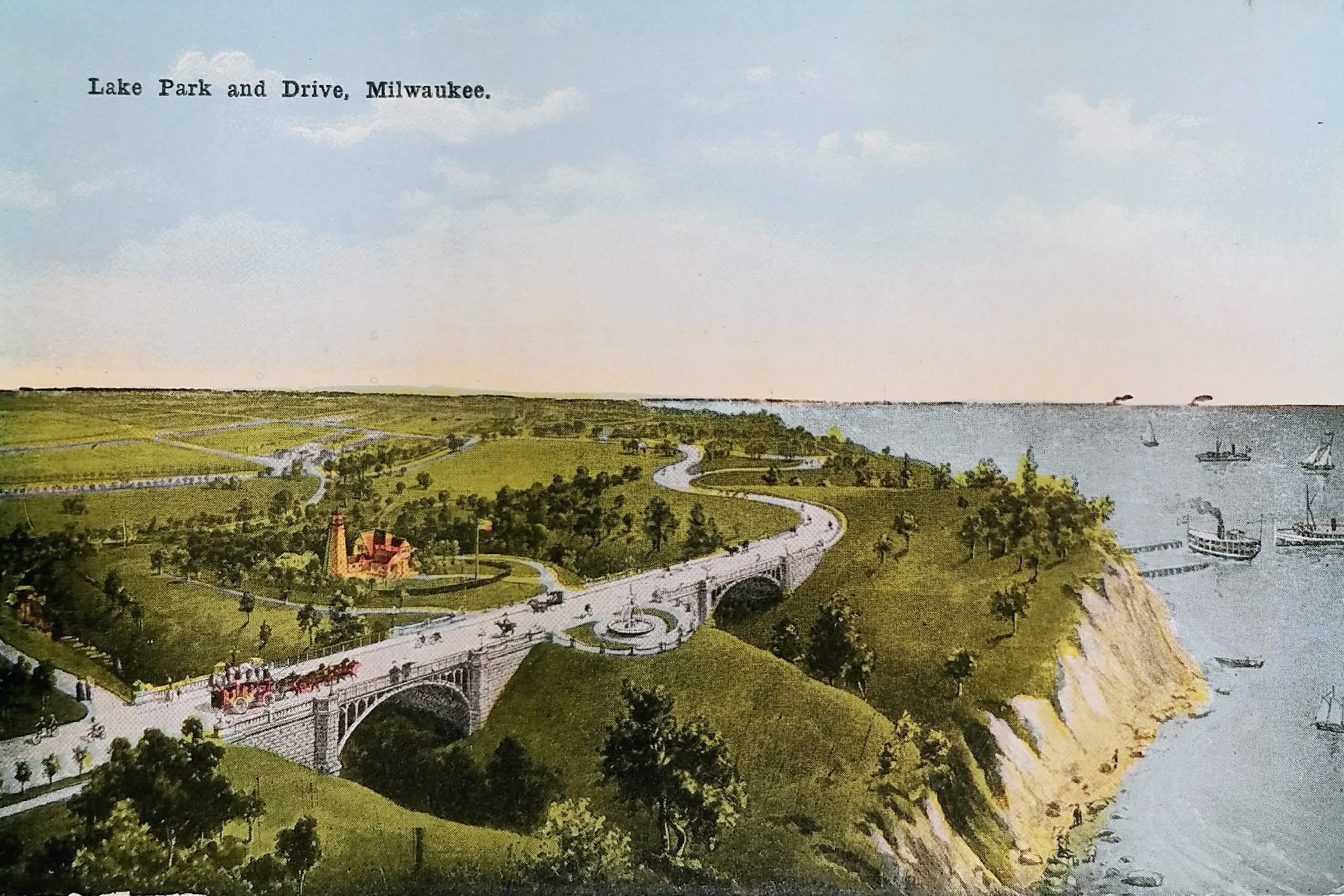
Today’s Lake Park is hardly recognizable in this postcard. It’s difficult to imagine the park with so few trees, isn’t it? This image depicts the park around 1900, after the Lion Bridges were complete but before other park facilities were added in the first decade of the 20th century.
The roadway pictured on the left portion of the postcard is now a pedestrian trail called the Oak Leaf Trail. The road in the upper right portion is today the Lake Park Road that leads to the Lake Park Bistro parking lot. The two “Lion Bridges” on either side of the lighthouse were constructed in 1896-97. In 1964, the bridges were narrowed and closed to vehicles. Today, that fountain between the bridges is gone, but you can still see the semicircular chain fence that remains.
The lighthouse is the North Point Lighthouse. The original lighthouse was built in 1855 but had to be abandoned because of bluff erosion. This lighthouse was built 100 feet further inland and began use in 1888. In 1907, the lighthouse began operating locally after Congress ceased funding due to trees and city lights obscuring the beacon.
The image shows the lighthouse at its 1888 height of 39 feet. In 1912, a new steel structure with the old iron tower attached on top raised the beacon to 74 feet from the ground. That is the lighthouse you can visit today. The U.S. Coast Guard decommissioned it in 1994.
Although the postcard is undated, it has a divided back, which means it was printed after 1907, but the image seems to reflect how Lake Park looked roughly a decade earlier. There are no trees growing to obscure the lighthouse. Also, by 1899, a horse barn (not pictured) was opened. In 1903 a 6-hole golf course was created just north of the lighthouse (also not pictured) and the pavilion (which today houses Lake Park Bistro) opened beyond that first bend of the roadway. Lake Park’s famous grand staircase, leading from landfill at the shore to the pavilion would come later, in 1908.
Lake Park was designed by Frederick Law Olmsted. He was the landscape architect responsible for Central Park in New York City and the grounds of Chicago’s Columbia Exposition.
At the time of this postcard, the bluff fell directly into the lake. Since then, landfill has been used to extend the shore for Lincoln Memorial Drive and the parks on Milwaukee’s lakeshore.
Roughly where those ships rest at the dock is where the Milwaukee Gun Club once had a shooting range on land created by the landfill. The gun club received a license for the land in 1928, but for five decades the county fought to evict the club, seeking to use the space for general park activity. The club agreed to move, then renigged on the promise, and finally went to court to try to keep the land. In 1992, after losing their case, the gun club finally agreed to abandon the site. Today, a rugby field is located approximately at this spot along the lakefront.
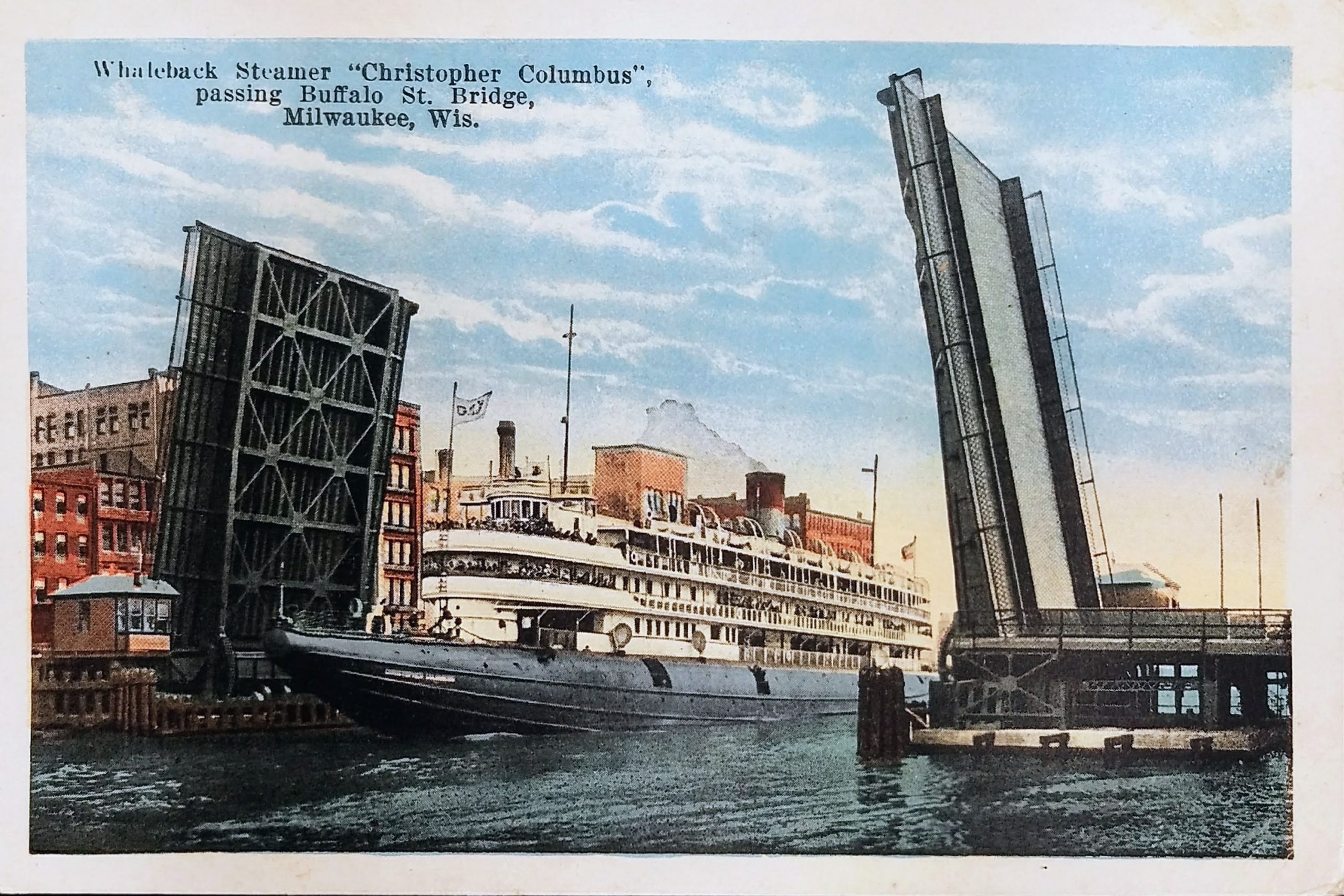
This undated postcard shows the Christopher Columbus passing the Buffalo St Bridge. Neither the boat nor the bridge exist any longer. This photo likely comes from the 1920s or early 1930s.
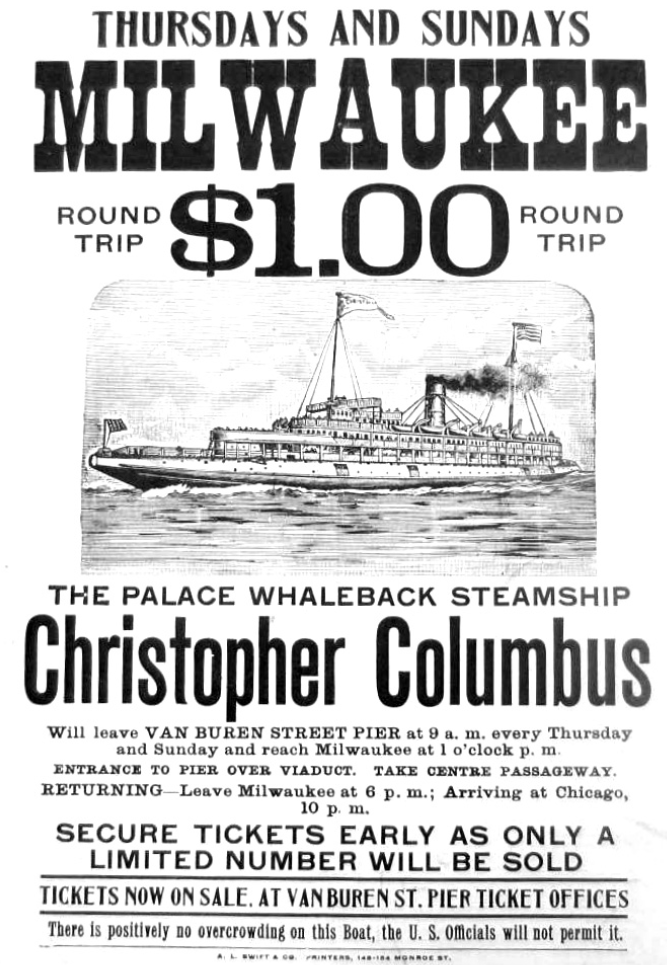
SS Christopher Columbus was the only whaleback ship ever built for passenger service. The ship was the longest whaleback ever built, and reportedly also the largest vessel on the Great Lakes when she was launched. She served as an excursion liner on the Great Lakes between 1893 and 1933 and began life shuttling visitors from downtown Chicago to the World’s Columbian Exposition. The ship could carry 4,000 to 5,000 passengers on her four decks, but it was reported that she carried 7,000 on her maiden voyage. She was scrapped in 1936.
The bridge at Buffalo Street was originally a swing bridge that pivoted on a center pier. In 1896, the Christopher Columbus hit the bridge, severely damaging the bridge. The draw bridge pictured here replaced the swing bridge in 1914. (That poor ship had its problems–in 1917, it collided with a water tower near Michigan Street in Milwaukee, sending the tower crashing onto the ship and killing passengers.)
The Buffalo Street bridge was removed in the late 1970s after the construction of the bridge over the river at St. Paul Avenue.
The postmark on this one is difficult to read but appears to be from 1909. This shot looks north on Water Street from the Iron Block building on Wisconsin. The only building in this photo that is still standing today is City Hall.
The postcard calls the street “East Water Street.” Today, this stretch of street is known as North Water Street, but prior to the 1930s, this was called East Water Street to differentiate it from West Water Street (now called Plankinton Avenue) which ran parallel to the river on the west.
The scene depicted was where Milwaukee was originally founded. Solomon Juneau’s cabin and trading post were located here in the early 19th Century.
To the left are the bottom floors of the Pabst Building (1892 to 1981).
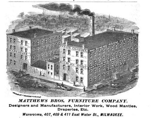
Just beyond that is the Matthews Bros building. Matthews Bros. was considered one of Milwaukee’s most celebrated furniture manufacturers. It was founded by brothers Eschines and Alonzo Matthews. They moved from Ohio to Milwaukee in 1856 and occupied many addresses before arriving at this spot. In 1857, Matthews Bros was founded on East Water between Biddle and Martin (now known as Kilbourn and State). Three years later they moved to a new location on East Water between Biddle and Oneida (Kilbourn and Wells). In 1863, the brothers relocated to a store on the west side of this block on East Water. In 1870, the firm built a manufacturing plant on 4th and Wisconsin that still stands today. In 1874, Matthews Bros moved their showroom from Water Street to Broadway, before finally arriving at this lovely building (401, 409 and 411 East Water Street) in 1879. This building was erected by the Philip Best Brewing Company. It was later occupied by Waldheim & Co. Furniture.
The Marshall & Ilsley Bank is not yet constructed on the west side of the street. That happened in 1913. And at the end of the block on the west side, the First Wisconsin National Bank would be built in 1914.
The focus on the shot is, of course, Milwaukee City Hall. Built in 1895, it was the tallest building in the world until 1899 (when NYC’s Park Row Building eclipsed it). It remained the tallest building in Milwaukee for 78 years. The upper part of the tower was rebuilt after a fire in October 1929.
City Hall was added to the National Register of Historic Places in 1973 and declared a National Historic Landmark in 2005.
This undated postcard shows the Wisconsin Tower, originally known as the Mariner Building, which still stands on the northwest corner of 6th and Wisconsin.
The 22-story art-deco office tower was built in 1930. The original name came from the developer, John W. Mariner, who died a few months before the building was completed. Upon completion, it was the second tallest building in Milwaukee. The name changed to the Wisconsin Tower in 1939. The building was converted to condominiums in 2005.
Generations knew this building because the west side was used for large billboards that spanned many floors. Here is an early shot with several advertisements on the side of the building: https://www.wisconsinhistory.org/Records/Image/IM129061
You can’t see it in this postcard, but the building featured a 50-foot steel mast for a revolving beacon light and radio towers on the roof. There have been rumors that the tower was intended as mooring for blimps, but apparently there is no proof of this. The tower was originally enclosed in glass and used as an airplane beacon. You can see the tower enclosed in glass in this old photo on the MPL website: http://content.mpl.org/cdm/singleitem/collection/HstoricPho/id/1055/rec/16
The 4-story building to the left, Central Market Apartments, was built in 1918 with a grocery market on the first floor and apartments above. It still stands today.
And to the left of that are the Norman Apartments, built in 1888 and demolished by fire in 1991.
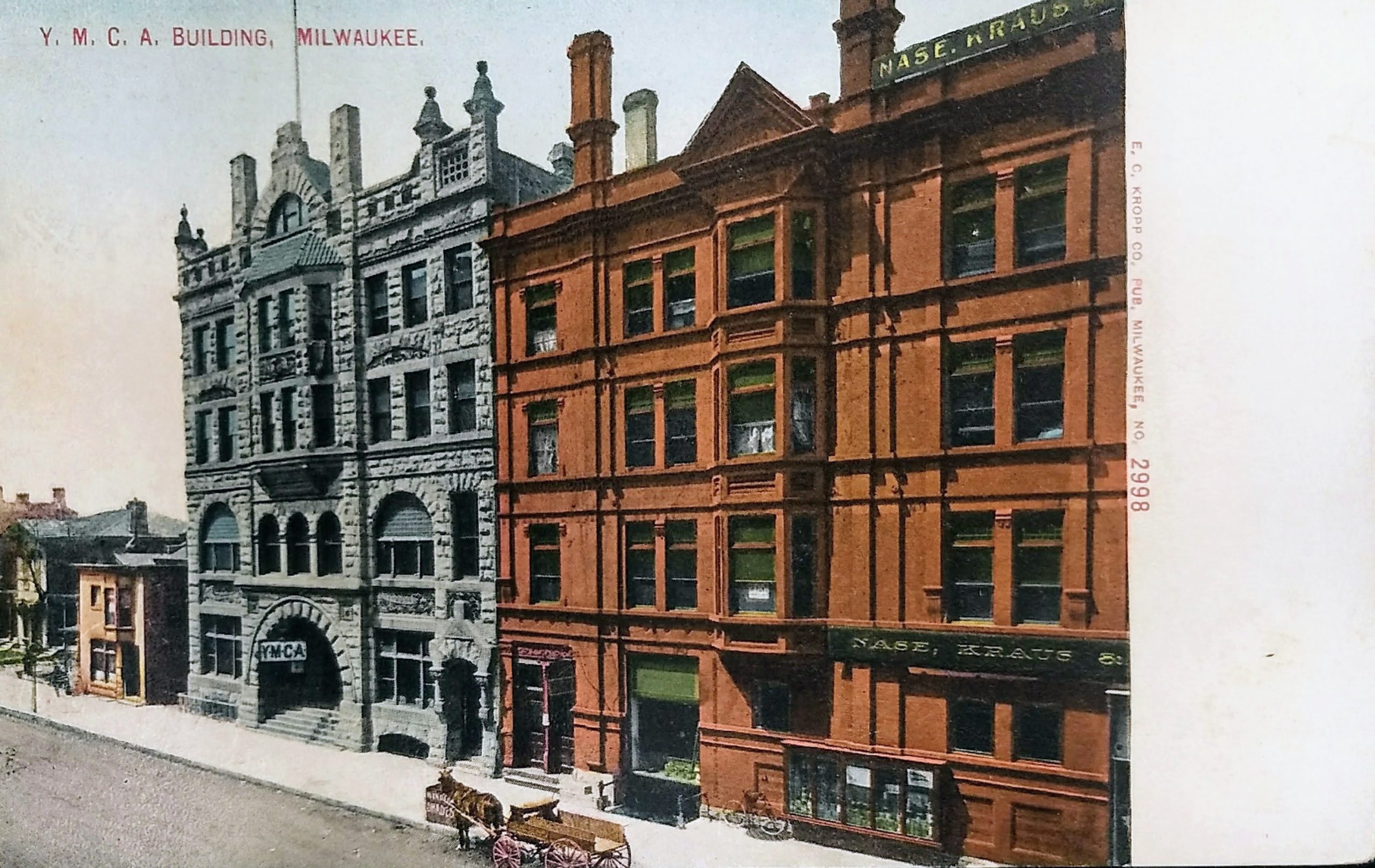
This postcard is undated but seems to be from the first decade of the 20th Century. We can ascertain the date because to the south of this YMCA building, which was built in 1887, the organization expanded by constructing a taller building in 1909. And beyond that, the Maryland Hotel was completed in 1910. Both YMCA buildings were demolished in 1966, and the Hotel Maryland came down in 1984.
This shot is of the west side of 4th Street between Wisconsin and Michigan Avenues. Today, this is an open parking lot on the north, and on the south is a parking structure with a skywalk to the old Boston Store building across the street.
In 1887, when this building opened, the Milwaukee YMCA was among the first in the nation to offer dormitories. The Milwaukee Y started separating men and boys, and this building became the “Boys building” when the larger extension was built for men next door.
The building on the right has signs for “Nase, Kraus & Koken,” a company that made wallpaper. This building was razed to make way for the New Hotel Randolph, which opened in 1927.
In 1981, the city’s Redevelopment Authority named this block a prime development site. In 1984 the city acquired the Randolph, and four months later, it closed the hotel and evicted its remaining tenants. On July 21, 1985, the building was imploded, and for over 35 years this “prime redevelopment site” has remained empty, operating as a surface parking lot.
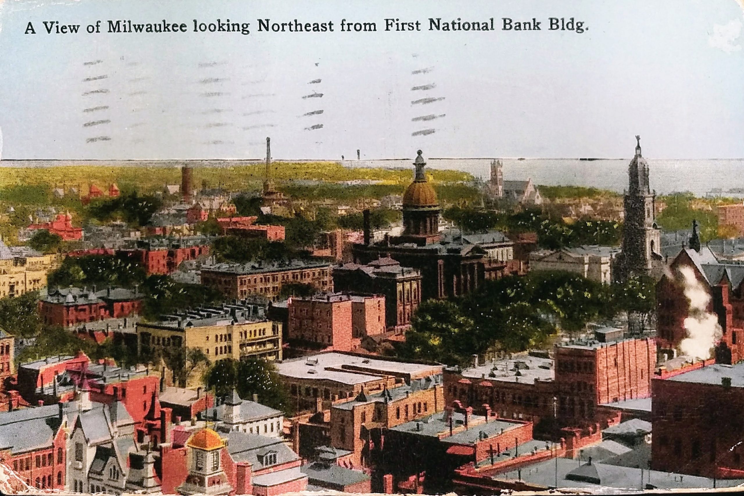
This postcard, postmarked 1916, shows the view northwest from the First National Bank Building on the southwest corner of Water and Mason Streets. The 16-story building was opened in 1914.
On the right side, you see the spire of the Cathedral of St. John the Evangelist. This is one of Milwaukee’s oldest buildings still standing. The church was built from 1847 to 1853, and the tower added in 1893 after the original spire deteriorated. A fire partially destroyed portions of the church in 1935, and it was rebuilt. St. John’s parish was founded in 1837 and was Milwaukee’s first Roman Catholic congregation. The parish church was elevated to cathedral status in 1841 when papal authority created the Milwaukee Archdiocese.
In front of the church is Court House Square, which today is known as Cathedral Square Park, but if you look closely, it is smaller than today’s park. In the northern half of today’s park footprint, you can see the old county courthouse–it’s the brown building with the large rotunda. The west wing of the courthouse was completed in 1869 and the remainder was finished in 1873. It was demolished in 1939 after the third and current courthouse was completed in 1931.
This was Milwaukee’s second courthouse. The first, which was located on this same site, was given to the county by Solomon Juneau, Milwaukee’s founder, and his partner, Morgan L. Martin. Juneau and Martin sold the land for the courthouse to the county for $1 with the stipulation it be used for public purposes and revert back to Juneau heirs if the courthouse was subsequently relocated.
In 1932, Juneau’s grandchildren threatened legal action to be compensated for the land, since the courthouse was being relocated. The County granted old-age pensions of $25 per month each to the three Juneau grandchildren (roughly $500 in 2020 dollars). Less than a year later, one of those grandchildren, Frank Juneau, passed away, and the Milwaukee Journal reported he had been penniless and living with his sisters in a home in Milwaukee’s Riverwest neighborhood. In fact, his sisters, Mary Stoughton Juneau and Pauline Juneau could no longer afford their shared home and were forced to seek a new residence upon the loss of their brother’s pension.
In the distance, you can see another church soaring on Milwaukee’s East Side. That is the Immanuel Presbyterian Church on Astor. It was built in 1874 and rebuilt in 1889 after a fire almost entirely destroyed the original.
Behind the courthouse (to the left in this postcard), you can see the four-story Jefferson Apartments. The entire building was moved approximately 50 feet to the north in 1940 due to street widening. It was demolished in 1967, and today MSOE Library occupies that spot.
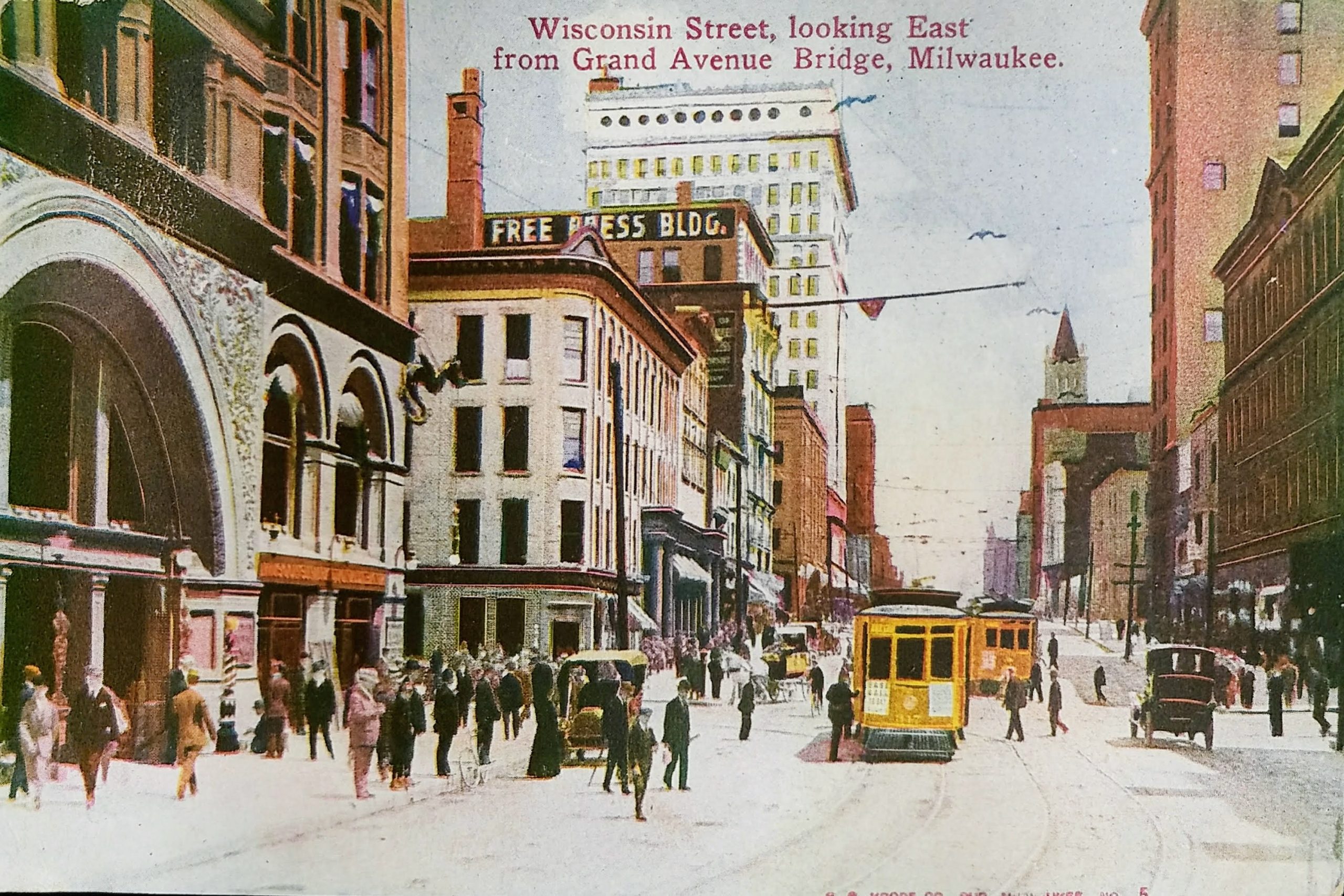
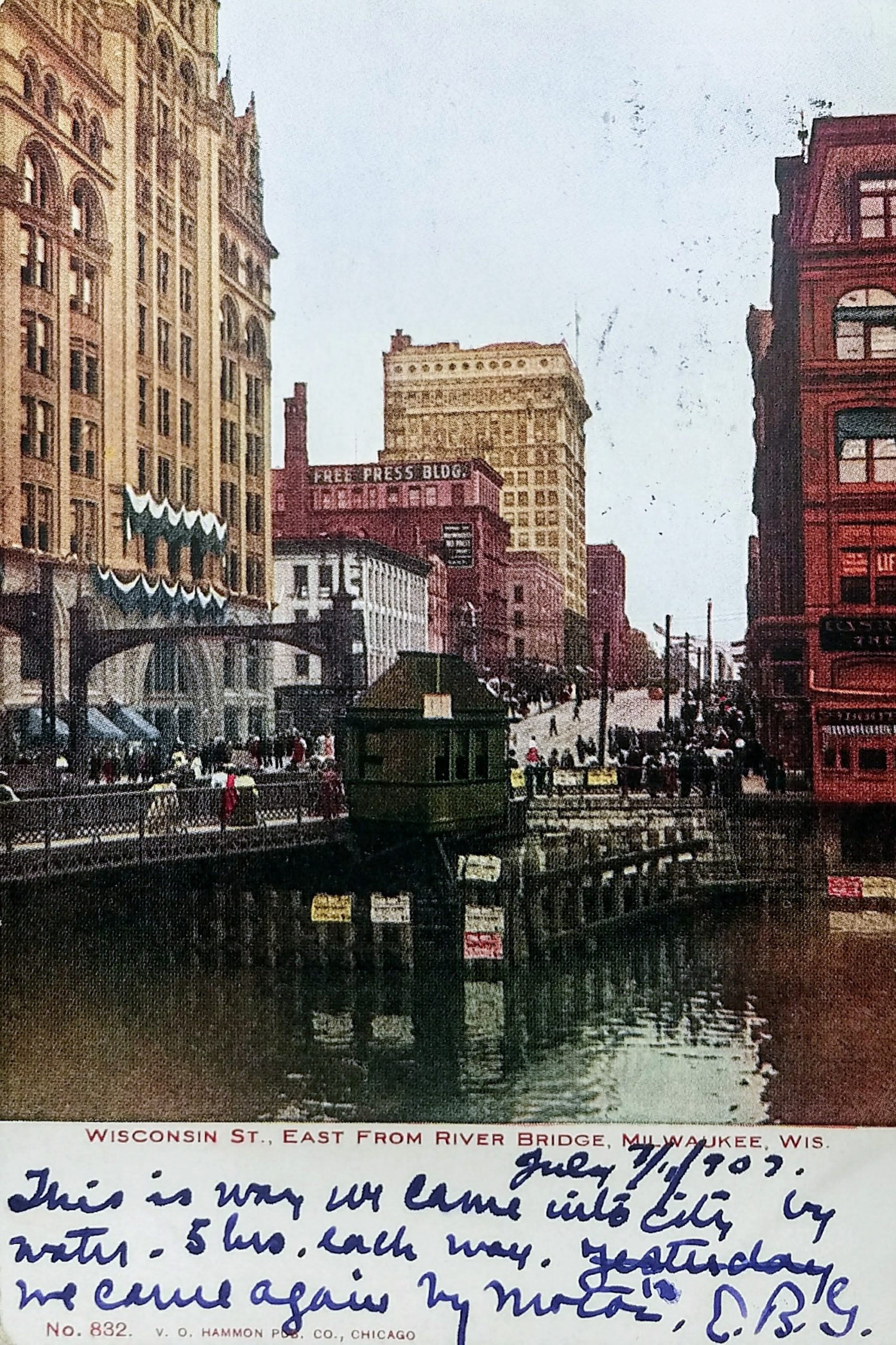
This postcard on top is postmarked 1910 and the one on the bottom is dated 1907. They show the view looking east on what is now Wisconsin Avenue from the east and west side of the bridge over the Milwaukee River. In this era, this route was known as Wisconsin Street east of the river and Grand Avenue west.
On the far right of the top postcard is the Iron Block (or Excelsior Block) Building, and rising behind it the Railway Exchange Building. In the distance, on the right, you can see the tower of the Federal Building. All three of these historic buildings still stand on the south side of Wisconsin Avenue.
On the lower postcard, the red building on the far right is the Mack building. It housed the Golden Eagle Clothing Store in its early years and the Marine Bank before it was razed to make way for Marine Bank tower (which is now Chase Tower). It was built in 1882 and demolished in 1959.
On the left, with the “Free Press” sign, is a building that was first known as the Insurance Building, later the Free Press Building, and finally the Broadway Building. It was built in 1870 and got its first name because it was Northwestern Mutual Life’s first Milwaukee office (after the company moved from Janesville). In 1885, the insurance firm moved one block south, to a building on the northwest corner of Broadway and Michigan.
The Broadway Building was one of the first buildings in Milwaukee to have elevators. It was also one of the first places where the new typewriter was given a trial, but Northwestern Mutual president H. L. Palmer rejected the innovation. Over the years, the character of the building changed quite a bit, as you can see from historic photos. It originally had a Mansard roof and a great deal of detail on the upper floors. In 1901, a fire partially destroyed the Mansard roof, and when the top floor was rebuilt, much of the detail was lost. In 1940, the six-story building was cut down to two floors, which were used for retail. Then, in 1965, the building was finally razed.
Behind the Broadway Building is the Wells Building, a 15-story structure with a white terra cotta brick exterior. It was built in 1901 and still stands today, although the ornate cornice work on the top floor was later removed due to deterioration and replaced with plain brick. The century-old building may not look it, but it’s a telecommunications hub for Milwaukee, and more than 30 carriers lease space here for data and voice gear.
This postcard comes from near the early part of the last century. The postmark appears to be 1907 (and the rear has an undivided back entirely dedicated to the address, which was required by law prior to 1907.) Postcards of this era featured colorized photos, and you can see the original photo shown in this postcard on the Milwaukee Public Library site.
This view is of Broadway in the Third Ward. The perspective is looking NNW from what is now the Broadway Condominiums on the southeast corner of Broadway and Buffalo Streets. Four tall buildings are seen in the distance on the right half of the postcard. From left to right they are the Pabst Building (built in 1892), City Hall (built in 1895), the Chamber of Commerce Building (or Mackie Building) (built in 1880), and the Railway Exchange Building (built in 1901). Of the four tall structures seen towering in the distance, three still stand today in downtown Milwaukee.
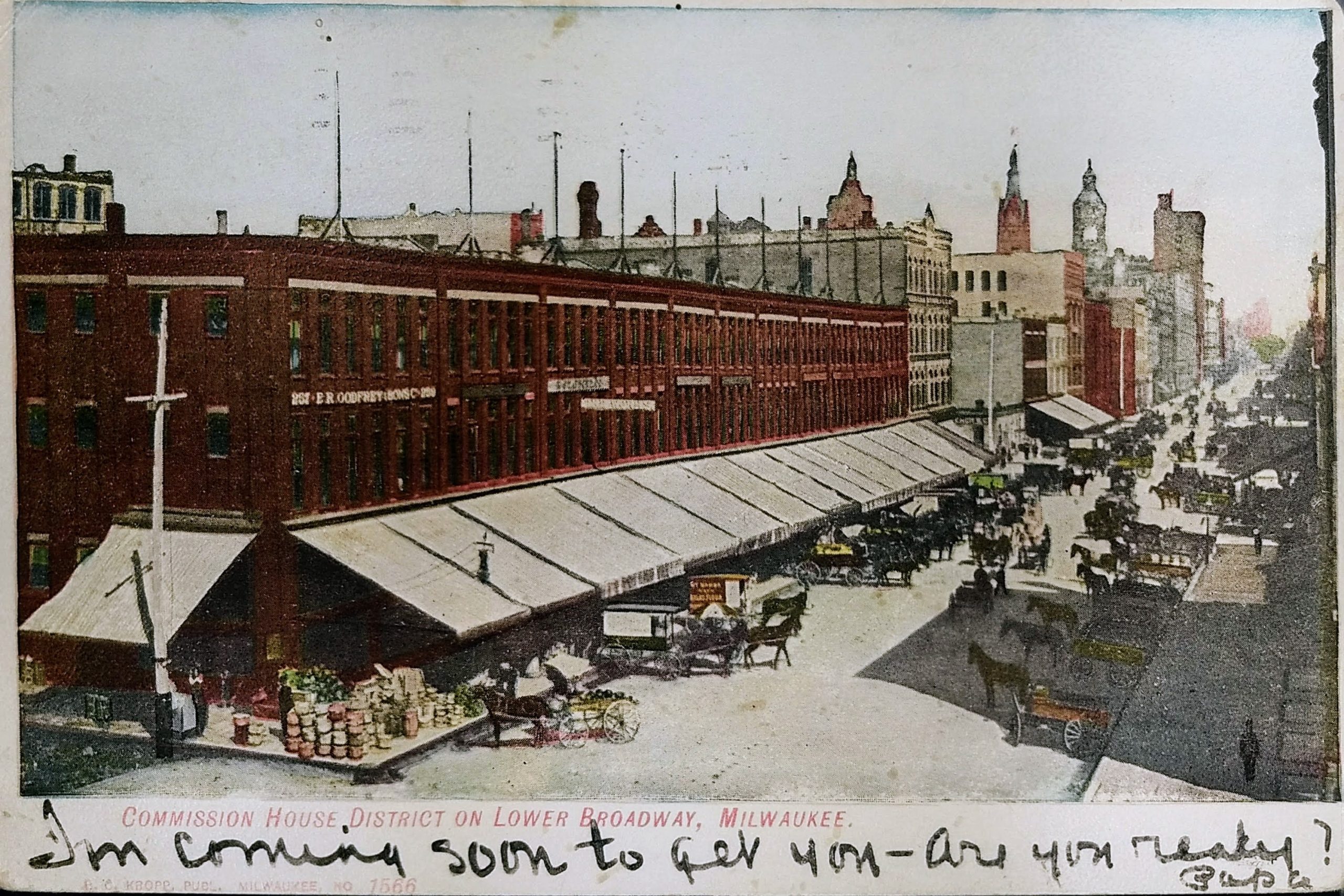
The Third Ward was very important to Milwaukee’s early success. In 1856, when the first railroad from Milwaukee reached the Mississippi River, Milwaukee wholesalers did more business than those in Chicago because Milwaukee was 90 miles closer by steamship to the east coast. By the late 19th Century, the highest concentration of wholesalers in the city was located in the Third Ward due to its location adjacent to the harbor, rivers, and railroads. By the end of the century, as railways competed with Great Lakes shipping, trade would start shifting to Chicago due to the expansion of rail systems to the south.
The Third Ward District is listed on the National Register of Historic Places. The 1984 registration notes that seventy-one buildings are contained within the roughly-twelve-block boundaries of the historic district, almost all of which are multi-story warehouses or industrial structures built between 1892 and 1928.
That first date is important because 1892 is when the Third Ward suffered an enormous and destructive fire. On October 28, 1892, a fire fueled by strong winds of up to 50 mph spread throughout the Third Ward. A small fire started in the Union Oil Co. warehouse on the west side of Water Street, north of Buffalo. Although it was thought to have been quickly brought under control, a fire broke out in a neighboring factory (the Bub and Kipp factory, which was located where Commission Row is now) an hour later. Before morning, three firefighters were dead, two women had died of apparent shock, 215 railroad cars were consumed, and 81 large brick buildings and 359 wood-frame structures were destroyed. 1,900 people, mostly Irish families, were left without homes.
Following the fire in 1892, Milwaukee rapidly replaced the lost buildings. Although many of the buildings lost were residential, the redevelopment focused on warehouses to take advantage of the easy water and rail shipping lines; as a result, the population of the Third Ward never recovered to its pre-fire totals. Today, 30% of the buildings remaining in the area date from the 1890s rebuilding period, and 98% of all buildings remaining in the district were built before the Crash of 1929.
Commission Row, featured in this postcard, was built by the Ludington Estate in 1894-95. As noted, it was built on the site of the Bub and Kipp factory, which was the second building destroyed in the Third Ward fire.
Just to the north, you’ll see a four-story cream-colored building that abutts Commission row. That was one of the few Third Ward buildings that escaped destruction in the 1892 fire and is the oldest manufacturing building in the district. The Jewett & Sherman Co. mill was built in 1875. By the 1940s, it was used as a commission house, then for offices and a restaurant. Today, The Wicked Hop is housed in this building.
The block to the north of the Jewett & Sherman (between the Third Ward and downtown) has changed considerably. The old buildings you see in the postcard were razed in the 1960s to make way for the elevated I-794 freeway. Today, you’ll also find the Milwaukee Public Market on that block, with the area under the freeway used for parking.
On a personal note, this view has a special meaning for my wife and me. We owned a pet boutique, Metropawlis, that was housed in small portion on the north end of this building from 2005 to 2009.
 Just over the bow of the ship, you can see the J. C. Iversen building. John C. Iversen established his picture-framing business in 1867 on Spring Street (later Grand Avenue). The business prospered and expanded in 1879 to this five-story building you see here on E. Water Street (now N. Water Street).
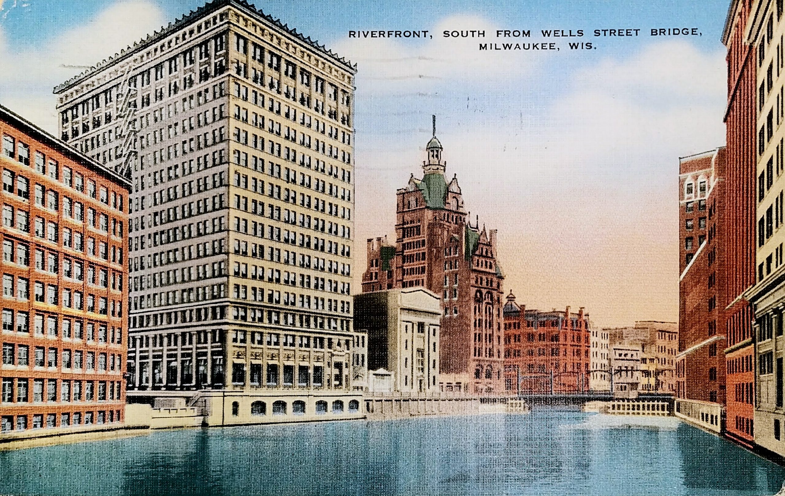
 SS Christopher Columbus was the only whaleback ship ever built for passenger service. The ship was the longest whaleback ever built, and reportedly also the largest vessel on the Great Lakes when she was launched. She served as an excursion liner on the Great Lakes between 1893 and 1933 and began life shuttling visitors from downtown Chicago to the World’s Columbian Exposition. The ship could carry 4,000 to 5,000 passengers on her four decks, but it was reported that she carried 7,000 on her maiden voyage. She was scrapped in 1936.
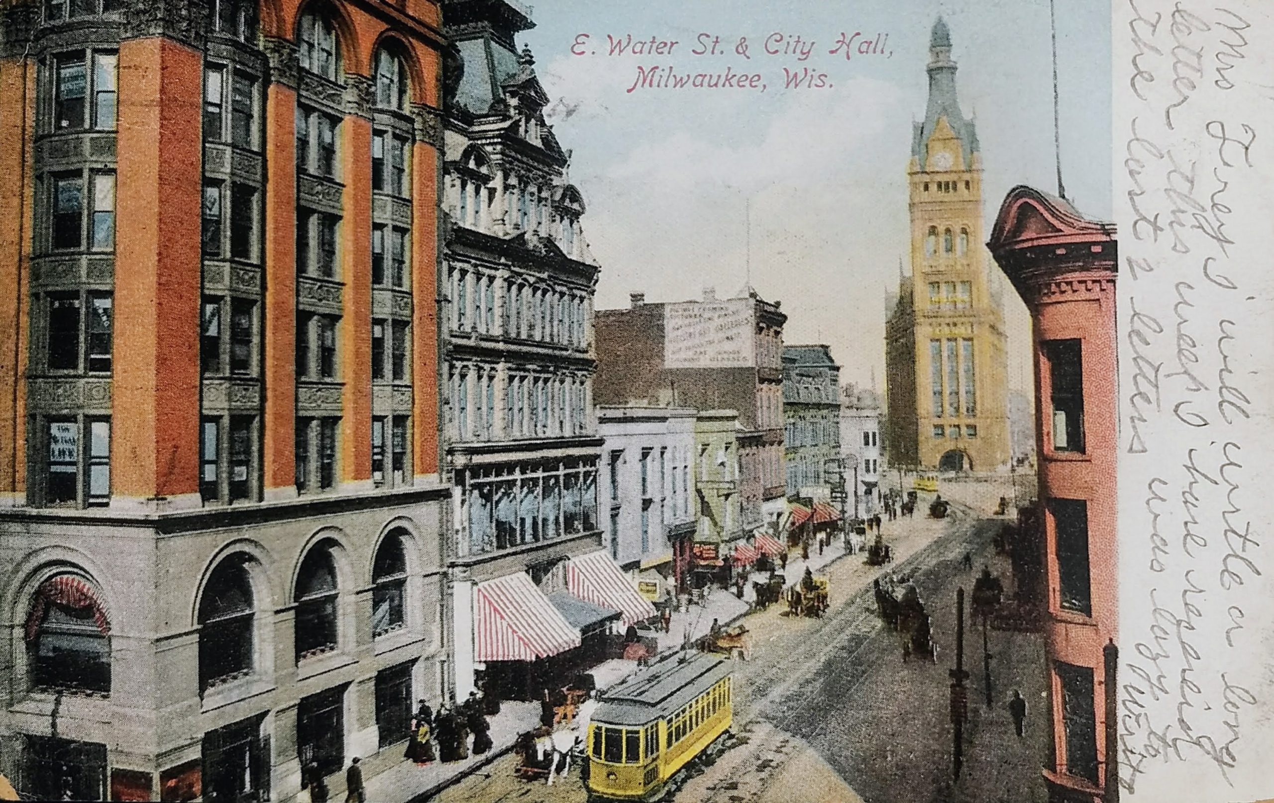
 Just beyond that is the Matthews Bros building. Matthews Bros. was considered one of Milwaukee’s most celebrated furniture manufacturers. It was founded by brothers Eschines and Alonzo Matthews. They moved from Ohio to Milwaukee in 1856 and occupied many addresses before arriving at this spot. In 1857, Matthews Bros was founded on East Water between Biddle and Martin (now known as Kilbourn and State). Three years later they moved to a new location on East Water between Biddle and Oneida (Kilbourn and Wells). In 1863, the brothers relocated to a store on the west side of this block on East Water. In 1870, the firm built
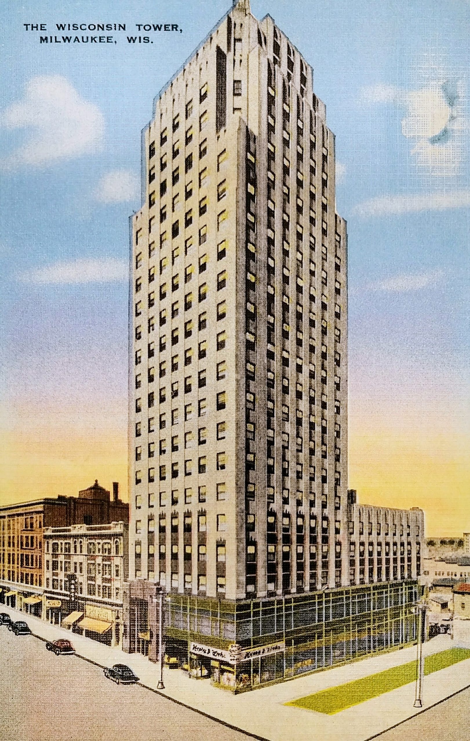
 The building on the right has signs for “Nase, Kraus & Koken,” a company that made wallpaper. This building was razed to make way for the