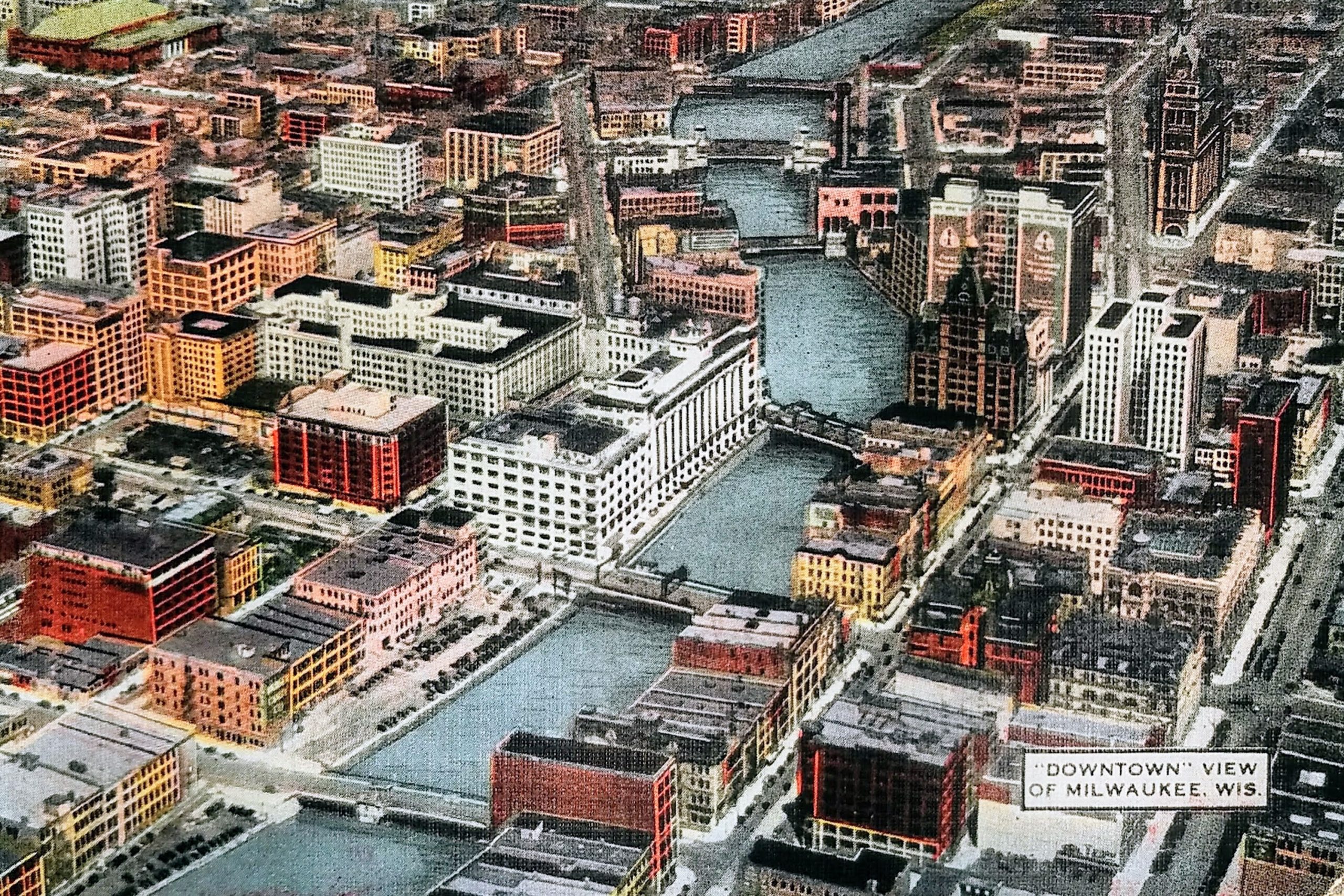
Here is a great, undated postcard of Milwaukee from the air. You can see many of downtown’s oldest buildings here. This view is from the 1930s or 1940s. The postcard contains the Centre Building (barely visible near 2nd and Wisconsin), which was built in 1931, but is missing the two-story Art Moderne parking garage Gimbels constructed in 1947 on the corner of Michigan and Plankinton.
On the top right is the City Hall (1895 to present).
Below and to the left of City Hall (with two large vertical signs) is the First Wisconsin National Bank Building (1914 to present). Below that is the distinctive Pabst Building (1892 to 1981). To the east (right) of the Pabst, the tall, white building with two wings is the Bankers Building, constructed in 1929 and still standing today as the Drury Plaza Hotel. South of the Pabst, along the east (right) side of the river, is a block of small buildings that were razed between 1959 to 1961 to make way for the Marine Bank building, including the Mack Block Building, National Exchange Bank, and Bradley Building.
On the right side of the postcard, midway from top to bottom, you can see a tall, thin, red building–that’s the Railway Exchange Building that still stands on Broadway and Wisconsin. Just south of the Railway Exchange building and north of Michigan Street is the Loyalty Building, built in 1886 as the second headquarters of Northwestern Mutual Life.
To the south of that, across Michigan (and right above label “‘Downtown’ View of Milwaukee, Wis.”) is the Chamber of Commerce Building or Mackie Building. You can see its distinctive tower. The ornate building was built in 1880 and still stands. To the left of that, the red building is the Mitchell Building (1878 to present).
A block south of that, to the left of the postcard label, is the Button Block building on Clybourn (once known as Huron St). It was built in 1892 and still stands today. It has had a number of clubs and restaurants on the first floor, from Park Avenue to Brett Favre’s Steakhouse. Today, it is the Homewood Suites.
Across the river you can see the buildings that comprised Gimbels–the northern part along Wisconsin Avenue built in 1923 and the southern portion along Michigan Avenue in 1920. Both still stand today. Peeking over Gimbels, on the north side of Wisconsin between Plankinton and the river, you can see the Empire Building, built in 1928. That still exists and houses the Riverside Theater.
The large, white, block-long building to the west (left) of Gimbels is the Plankinton Arcade. This is how it looked after 1925, when an additional five floors were added to the original two-story building. In the same block, south of the Plankinton Arcade, you can see two buildings that no longer exist. On the corner of Michigan And Plankinton, the large, red, eight-story building is the Plankinton Hotel (1917 to 1980). (I actually got to see a portion of this come down while visiting downtown with my folks.) And along 2nd Street, to the north of the surface parking lot, is the 11-story Hotel Antlers.
A block north of the Plankinton Arcade, you can see eight-story, five-sided Brumder Building or Germania Building. It has a bit of an odd shape to match the block it’s on and features four distinctive covered domes in the shape of Kaiser helmets on its roof. It was originally named the Germania Building, but they changed the name during WWII in honor of the owner, George Brumder (and to obscure the German reference). That was built in 1896 and still stands today.
Above the Germania Building, you can see another building that still stands today. The reddish/brown, nine-story Chalet At The River Building. It was built as a six-story building in 1908, and the top three floors added in 1913. To the left of that is a white building called the Century Building. It was built in 1925 and had Radio Doctors on the first floor from 1961 to 1991.
And, finally, in far upper left corner, you see the Milwaukee Auditorium (now known as the Miller High Life Theatre.) In 1950, the Milwaukee Arena would be built to the east of the Auditorium.
Identifier:
Approximate Google Earth View today: