Postcard: E. Water St. & City Hall, Milwaukee, Wis.

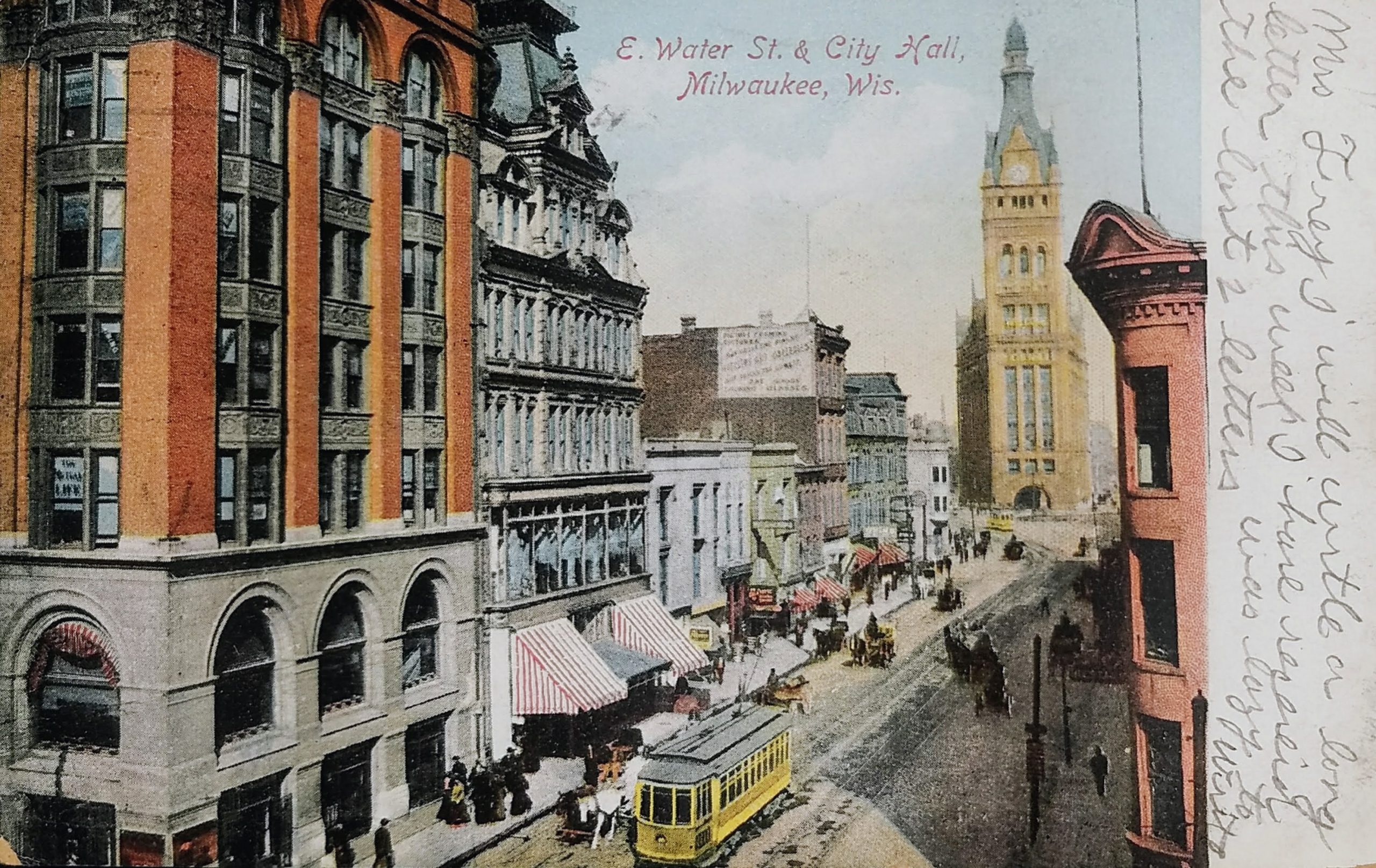
The postmark on this one is difficult to read but appears to be from 1909. This shot looks north on Water Street from the Iron Block building on Wisconsin. The only building in this photo that is still standing today is City Hall.

The postcard calls the street “East Water Street.” Today, this stretch of street is known as North Water Street, but prior to the 1930s, this was called East Water Street to differentiate it from West Water Street (now called Plankinton Avenue) which ran parallel to the river on the west.

The scene depicted was where Milwaukee was originally founded. Solomon Juneau’s cabin and trading post were located here in the early 19th Century.

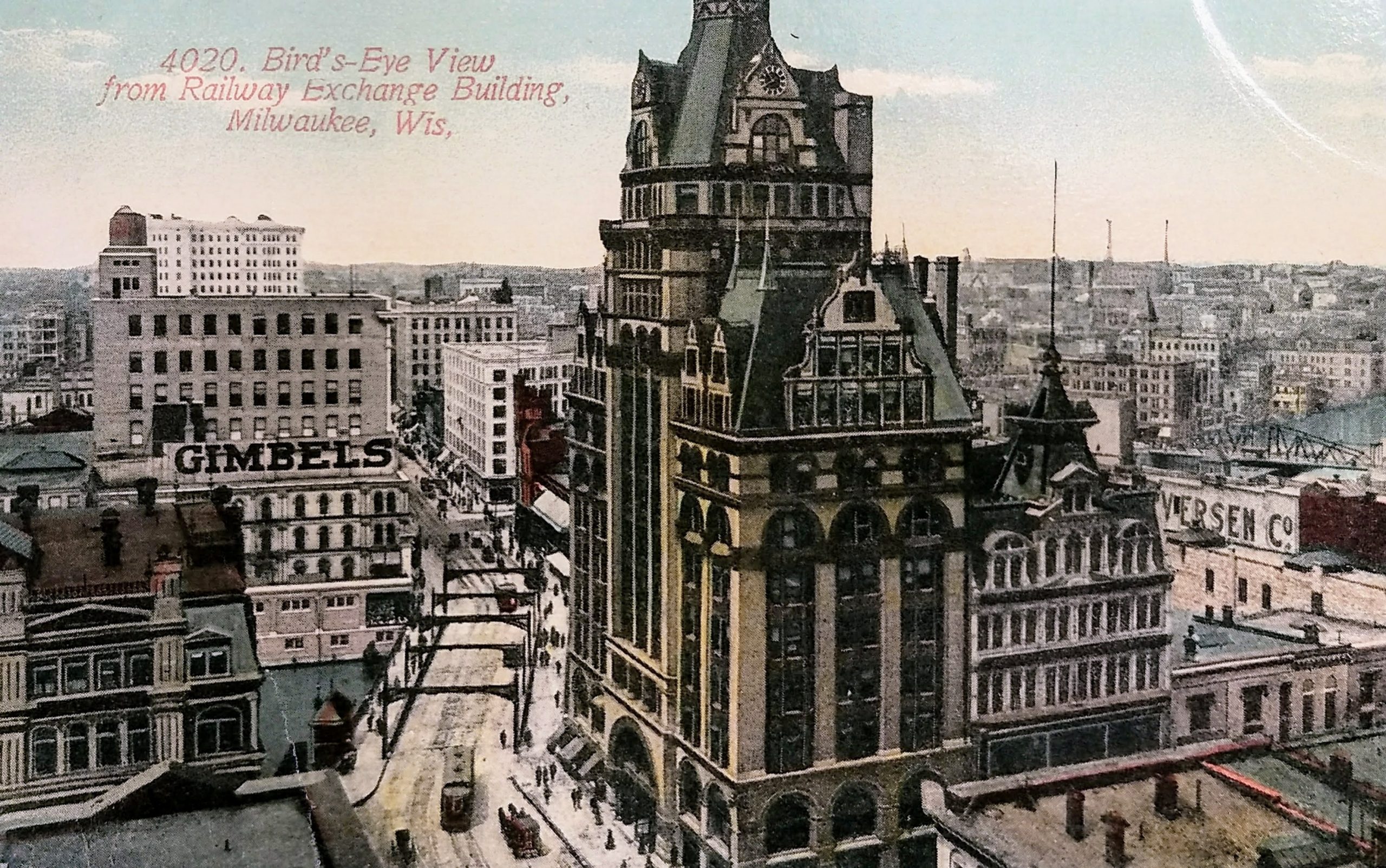
To the left are the bottom floors of the Pabst Building (1892 to 1981).

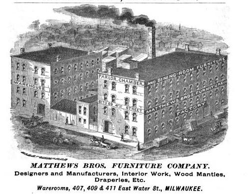
Just beyond that is the Matthews Bros building. Matthews Bros. was considered one of Milwaukee’s most celebrated furniture manufacturers. It was founded by brothers Eschines and Alonzo Matthews. They moved from Ohio to Milwaukee in 1856 and occupied many addresses before arriving at this spot. In 1857, Matthews Bros was founded on East Water between Biddle and Martin (now known as Kilbourn and State). Three years later they moved to a new location on East Water between Biddle and Oneida (Kilbourn and Wells). In 1863, the brothers relocated to a store on the west side of this block on East Water. In 1870, the firm built a manufacturing plant on 4th and Wisconsin that still stands today. In 1874, Matthews Bros moved their showroom from Water Street to Broadway, before finally arriving at this lovely building (401, 409 and 411 East Water Street) in 1879. This building was erected by the Philip Best Brewing Company. It was later occupied by Waldheim & Co. Furniture.

The Marshall & Ilsley Bank is not yet constructed on the west side of the street. That happened in 1913. And at the end of the block on the west side, the First Wisconsin National Bank would be built in 1914.

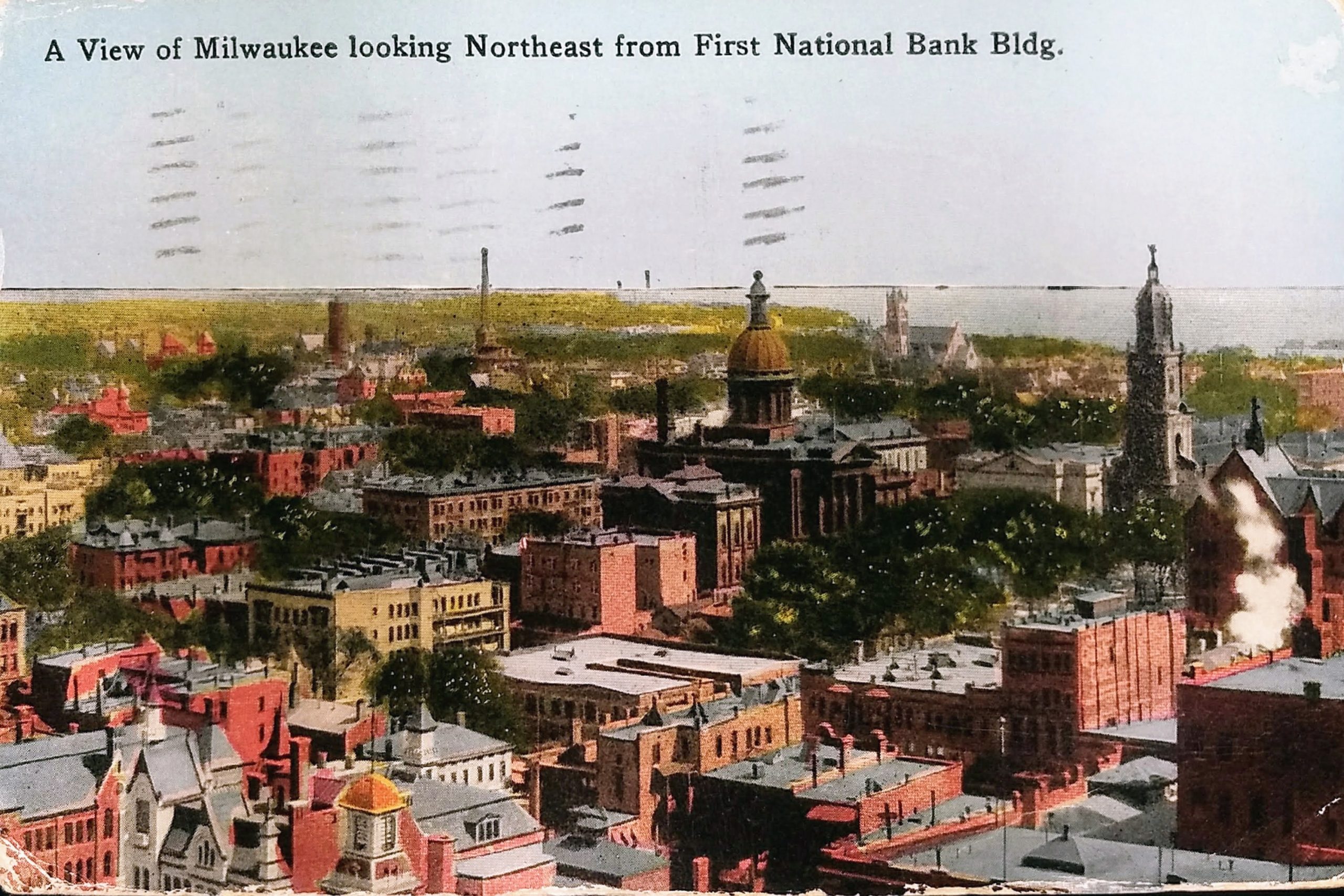
The focus on the shot is, of course, Milwaukee City Hall. Built in 1895, it was the tallest building in the world until 1899 (when NYC’s Park Row Building eclipsed it). It remained the tallest building in Milwaukee for 78 years. The upper part of the tower was rebuilt after a fire in October 1929.

City Hall was added to the National Register of Historic Places in 1973 and declared a National Historic Landmark in 2005.

Sources:

https://books.google.com/books?id=7CXCkW3FOAgC&lpg=PA210&ots=n7IWBFVU2e&dq=407%20409%20411%20%22east%20water%20street%22%20milwaukee&pg=PA210#v=onepage&q=407%20409%20411%20%22east%20water%20street%22%20milwaukee&f=false

https://books.google.com/books?id=CQVJAQAAMAAJ&lpg=PA31&ots=A_M3wGkSg8&dq=407%20409%20411%20%22east%20water%20street%22%20milwaukee&pg=PA31#v=onepage&q=407%20409%20411%20%22east%20water%20street%22%20milwaukee&f=false

https://books.google.com/books?id=8JgvAQAAMAAJ&lpg=PA1518&ots=hXB895NXWb&dq=407%20409%20411%20%22east%20water%20street%22%20milwaukee&pg=PA1518#v=onepage&q=407%20409%20411%20%22east%20water%20street%22%20milwaukee&f=false

https://brittlebooks.library.illinois.edu/brittlebooks_open/Books2008-06/buckja0001piohis/buckja0001piohisv00004/buckja0001piohisv00004.pdf

https://urbanmilwaukee.com/2016/02/09/yesterdays-milwaukee-pabst-building-1890s/

https://www.worldofarchi.com/2013/01/tallest-building-in-world-tittle.html

https://npgallery.nps.gov/NRHP/AssetDetail?assetID=7cd2a2c0-6aae-47bf-aade-4c798c0824f6

Identifiers:

PLUS Code for City Hall: 23RR+G4 Milwaukee, Wisconsin

Approximate Google Earth View today: https://earth.google.com/web/@43.03900673,-87.909298,190.90933456a,63.58584328d,35y,-26.85735666h,80.8908923t,0r/data=ClYaVBJOCiUweDg4MDUxOWE3NGMxMDRhODc6MHg3YzMyZWMyMDNlODJmOWRhGZ9VZkrrhEVAIYYRDDEo-lXAKhNJcm9uIEJsb2NrIEJ1aWxkaW5nGAIgAQ

Approximate Google Street View today: https://goo.gl/maps/z9qVw2B3GfdcU7S17

Postcard: The Wisconsin Tower, Milwaukee, WI

This undated postcard shows the Wisconsin Tower, originally known as the Mariner Building, which still stands on the northwest corner of 6th and Wisconsin.

The 22-story art-deco office tower was built in 1930. The original name came from the developer, John W. Mariner, who died a few months before the building was completed. Upon completion, it was the second tallest building in Milwaukee. The name changed to the Wisconsin Tower in 1939. The building was converted to condominiums in 2005.

Generations knew this building because the west side was used for large billboards that spanned many floors. Here is an early shot with several advertisements on the side of the building: https://www.wisconsinhistory.org/Records/Image/IM129061

You can’t see it in this postcard, but the building featured a 50-foot steel mast for a revolving beacon light and radio towers on the roof. There have been rumors that the tower was intended as mooring for blimps, but apparently there is no proof of this. The tower was originally enclosed in glass and used as an airplane beacon. You can see the tower enclosed in glass in this old photo on the MPL website: http://content.mpl.org/cdm/singleitem/collection/HstoricPho/id/1055/rec/16

The 4-story building to the left, Central Market Apartments, was built in 1918 with a grocery market on the first floor and apartments above. It still stands today.

And to the left of that are the Norman Apartments, built in 1888 and demolished by fire in 1991.

Sources:

https://en.wikipedia.org/wiki/Wisconsin_Tower

https://www.wisconsinhistory.org/Records/Property/HI41849

https://www.wisconsinhistory.org/Records/Property/HI66797

https://www.wisconsinhistory.org/Records/Property/HI111506

Identifiers:

PLUS Code: 23QJ+M7 Milwaukee, Wisconsin

Approximate Google Street View Today: https://goo.gl/maps/wFXpUtd2fetGy7Ym6

Postcard: Y.M.C.A. Building, Milwaukee

This postcard is undated but seems to be from the first decade of the 20th Century. We can ascertain the date because to the south of this YMCA building, which was built in 1887, the organization expanded by constructing a taller building in 1909. And beyond that, the Maryland Hotel was completed in 1910. Both YMCA buildings were demolished in 1966, and the Hotel Maryland came down in 1984.

This shot is of the west side of 4th Street between Wisconsin and Michigan Avenues. Today, this is an open parking lot on the north, and on the south is a parking structure with a skywalk to the old Boston Store building across the street.

In 1887, when this building opened, the Milwaukee YMCA was among the first in the nation to offer dormitories. The Milwaukee Y started separating men and boys, and this building became the “Boys building” when the larger extension was built for men next door.

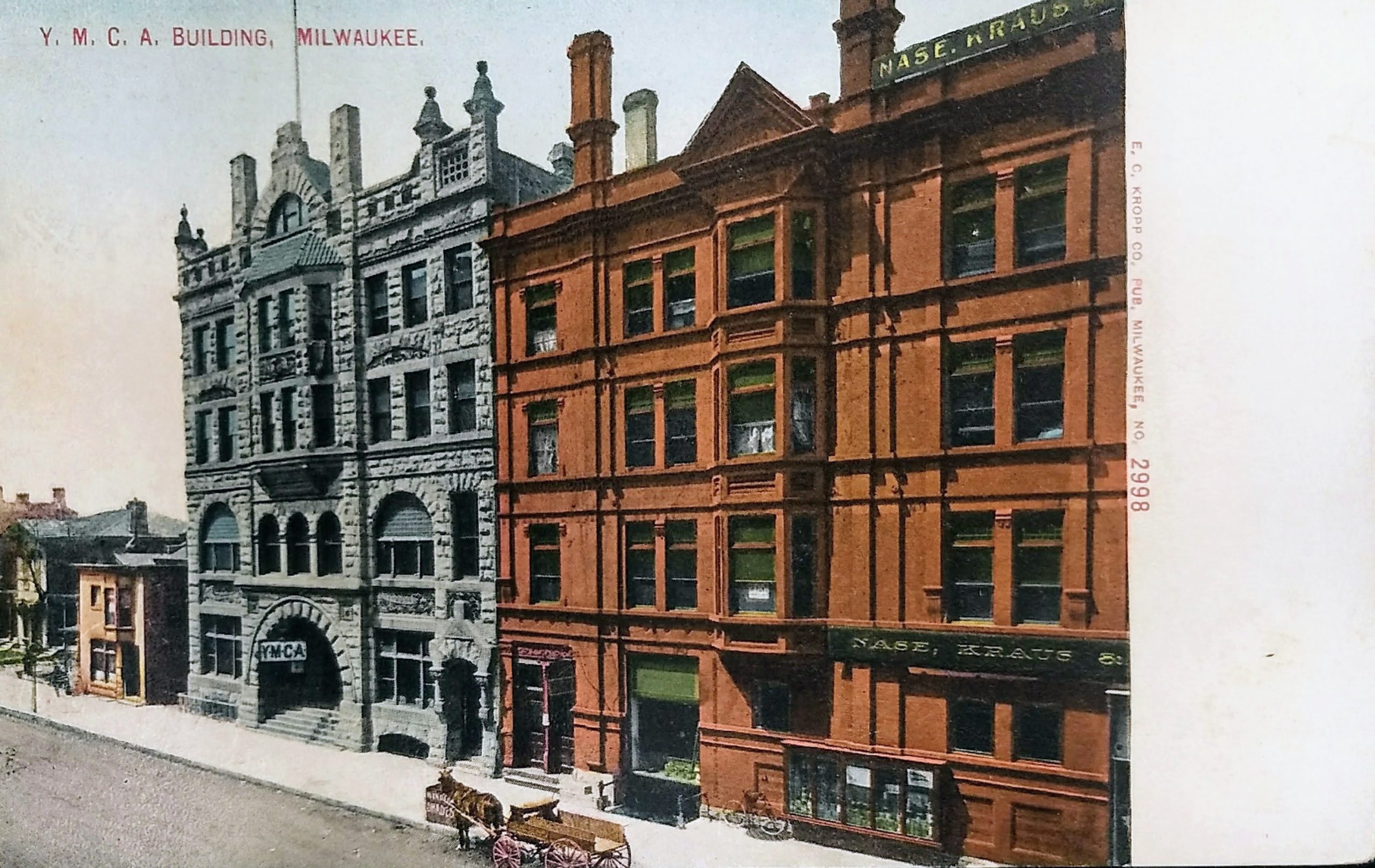
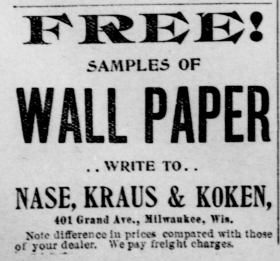
The building on the right has signs for “Nase, Kraus & Koken,” a company that made wallpaper. This building was razed to make way for the New Hotel Randolph, which opened in 1927.

In 1981, the city’s Redevelopment Authority named this block a prime development site. In 1984 the city acquired the Randolph, and four months later, it closed the hotel and evicted its remaining tenants. On July 21, 1985, the building was imploded, and for over 35 years this “prime redevelopment site” has remained empty, operating as a surface parking lot.

Sources:

https://content.mpl.org/digital/collection/RememberWhe/id/265

https://books.google.com/books?id=2ZkxNOeCns0C&lpg=PP1&pg=PA125#v=onepage&q=Milwaukee%20YMCA&f=false

https://books.google.com/books?id=wiyr3GYXiIEC&lpg=PA152&ots=6C2uKHo0cI&dq=Milwaukee%20YMCA%20was%20among%20the%20first%20in%20the%20nation%20to%20offer%20dormitories&pg=PA152#v=onepage&q=Milwaukee%20YMCA%20was%20among%20the%20first%20in%20the%20nation%20to%20offer%20dormitories&f=false

https://books.google.com/books?id=D9neAAAAMAAJ&lpg=PA82&ots=AjvFYgBACb&dq=Milwaukee%20YMCA%20%22Boys%20building%22&pg=PA82#v=onepage&q=Milwaukee%20YMCA%20%22Boys%20building%22&f=false

http://archive.jsonline.com/greensheet/randolph-hotel-came-tumbling-down-on-wisconsin-ave–in-1985-b99698896z1-374701041.html

Identifiers:

PLUS Code: 23QM+7G Milwaukee, Wisconsin

Approximate Google Street View today: https://goo.gl/maps/WRg4U2GcCwaWfUrf8

Postcard: A View of Milwaukee looking Northeast from First National Bank Bldg.

This postcard, postmarked 1916, shows the view northwest from the First National Bank Building on the southwest corner of Water and Mason Streets. The 16-story building was opened in 1914.

On the right side, you see the spire of the Cathedral of St. John the Evangelist. This is one of Milwaukee’s oldest buildings still standing. The church was built from 1847 to 1853, and the tower added in 1893 after the original spire deteriorated. A fire partially destroyed portions of the church in 1935, and it was rebuilt. St. John’s parish was founded in 1837 and was Milwaukee’s first Roman Catholic congregation. The parish church was elevated to cathedral status in 1841 when papal authority created the Milwaukee Archdiocese.

In front of the church is Court House Square, which today is known as Cathedral Square Park, but if you look closely, it is smaller than today’s park. In the northern half of today’s park footprint, you can see the old county courthouse–it’s the brown building with the large rotunda. The west wing of the courthouse was completed in 1869 and the remainder was finished in 1873. It was demolished in 1939 after the third and current courthouse was completed in 1931.

This was Milwaukee’s second courthouse. The first, which was located on this same site, was given to the county by Solomon Juneau, Milwaukee’s founder, and his partner, Morgan L. Martin. Juneau and Martin sold the land for the courthouse to the county for $1 with the stipulation it be used for public purposes and revert back to Juneau heirs if the courthouse was subsequently relocated.

In 1932, Juneau’s grandchildren threatened legal action to be compensated for the land, since the courthouse was being relocated. The County granted old-age pensions of $25 per month each to the three Juneau grandchildren (roughly $500 in 2020 dollars). Less than a year later, one of those grandchildren, Frank Juneau, passed away, and the Milwaukee Journal reported he had been penniless and living with his sisters in a home in Milwaukee’s Riverwest neighborhood. In fact, his sisters, Mary Stoughton Juneau and Pauline Juneau could no longer afford their shared home and were forced to seek a new residence upon the loss of their brother’s pension.

In the distance, you can see another church soaring on Milwaukee’s East Side. That is the Immanuel Presbyterian Church on Astor. It was built in 1874 and rebuilt in 1889 after a fire almost entirely destroyed the original.

Behind the courthouse (to the left in this postcard), you can see the four-story Jefferson Apartments. The entire building was moved approximately 50 feet to the north in 1940 due to street widening. It was demolished in 1967, and today MSOE Library occupies that spot.

Sources:

https://www.wisconsinhistory.org/Records/Property/HI27243

https://urbanmilwaukee.com/2014/12/04/yesterdays-milwaukee-county-courthouse-early-1870s/

https://collections.lib.uwm.edu/digital/collection/mkenh/id/322

https://0-infoweb-newsbank-com.countycat.mcfls.org/apps/news/openurl?ctx_ver=z39.88-2004&rft_id=info%3Asid/infoweb.newsbank.com&svc_dat=WORLDNEWS&req_dat=0D8DE8DE83992E4A&rft_val_format=info%3Aofi/fmt%3Akev%3Amtx%3Actx&rft_dat=document_id%3Aimage%252Fv2%253A1477BBDEA50EB75C%2540EANX-NB-16477F6854A413FD%25402426885-16476F7DB5A8C337%254012-16476F7DB5A8C337%2540/hlterms%3ASolomon%2520Juneau%2520courthouse%2520lawsuit

https://0-infoweb-newsbank-com.countycat.mcfls.org/apps/news/openurl?ctx_ver=z39.88-2004&rft_id=info%3Asid/infoweb.newsbank.com&svc_dat=WORLDNEWS&req_dat=0D8DE8DE83992E4A&rft_val_format=info%3Aofi/fmt%3Akev%3Amtx%3Actx&rft_dat=document_id%3Aimage%252Fv2%253A1477BBDEA50EB75C%2540EANX-NB-16471F16335B3F04%25402427193-164719AE506FB8A1%254016-164719AE506FB8A1%2540/hlterms%3A%2522Mary%2520Stoughton%2520Juneau%2522

https://0-infoweb-newsbank-com.countycat.mcfls.org/apps/news/openurl?ctx_ver=z39.88-2004&rft_id=info%3Asid/infoweb.newsbank.com&svc_dat=WORLDNEWS&req_dat=0D8DE8DE83992E4A&rft_val_format=info%3Aofi/fmt%3Akev%3Amtx%3Actx&rft_dat=document_id%3Aimage%252Fv2%253A1477BBDEA50EB75C%2540EANX-NB-16471F32AE56E1CC%25402427200-16471CCE712D2C81%254016-16471CCE712D2C81%2540/hlterms%3A%2522Mary%2520Stoughton%2520Juneau%2522

https://www.wisconsinhistory.org/Records/Image/IM56048

Identifiers:

PLUS Code: 23QR+W6 Milwaukee, Wisconsin

Approximate Google Earth view today: https://earth.google.com/web/@43.0419021,-87.90533862,205.66577421a,252.50339622d,35y,46.4303776h,81.11410777t,-0r/data=Cl8aXRJXCiUweDg4MDUxOTA0MGU3ZWJkNDc6MHhiMWExNDM2YzE4NWYzMGEwGU74W_HDhUVAIXqcs0-R-VXAKhxJbW1hbnVlbCBQcmVzYnl0ZXJpYW4gQ2h1cmNoGAEgAQ

Postcards: Wisconsin Street, looking East from Grand Avenue Bridge, Milwaukee

This postcard on top is postmarked 1910 and the one on the bottom is dated 1907. They show the view looking east on what is now Wisconsin Avenue from the east and west side of the bridge over the Milwaukee River. In this era, this route was known as Wisconsin Street east of the river and Grand Avenue west.

On the far right of the top postcard is the Iron Block (or Excelsior Block) Building, and rising behind it the Railway Exchange Building. In the distance, on the right, you can see the tower of the Federal Building. All three of these historic buildings still stand on the south side of Wisconsin Avenue.

On the lower postcard, the red building on the far right is the Mack building. It housed the Golden Eagle Clothing Store in its early years and the Marine Bank before it was razed to make way for Marine Bank tower (which is now Chase Tower). It was built in 1882 and demolished in 1959.

On the left is the Pabst Building. From this vantage point, you can see the lovely stone archway that preservationists unsuccessfully tried to save when the building was razed.

On the left, with the “Free Press” sign, is a building that was first known as the Insurance Building, later the Free Press Building, and finally the Broadway Building. It was built in 1870 and got its first name because it was Northwestern Mutual Life’s first Milwaukee office (after the company moved from Janesville). In 1885, the insurance firm moved one block south, to a building on the northwest corner of Broadway and Michigan.

The Broadway Building was one of the first buildings in Milwaukee to have elevators. It was also one of the first places where the new typewriter was given a trial, but Northwestern Mutual president H. L. Palmer rejected the innovation. Over the years, the character of the building changed quite a bit, as you can see from historic photos. It originally had a Mansard roof and a great deal of detail on the upper floors. In 1901, a fire partially destroyed the Mansard roof, and when the top floor was rebuilt, much of the detail was lost. In 1940, the six-story building was cut down to two floors, which were used for retail. Then, in 1965, the building was finally razed.

Behind the Broadway Building is the Wells Building, a 15-story structure with a white terra cotta brick exterior. It was built in 1901 and still stands today, although the ornate cornice work on the top floor was later removed due to deterioration and replaced with plain brick. The century-old building may not look it, but it’s a telecommunications hub for Milwaukee, and more than 30 carriers lease space here for data and voice gear.

Sources:

https://content.mpl.org/digital/collection/RememberWhe/id/411/

https://content.mpl.org/digital/collection/HstoricPho/id/1152

https://content.mpl.org/digital/collection/HstoricPho/id/360/rec/6

https://content.mpl.org/digital/collection/HstoricPho/id/266

https://content.mpl.org/digital/collection/HstoricPho/id/448

https://www.wisconsinhistory.org/Records/Image/IM48075

https://books.google.com/books?id=kSr9CwAAQBAJ&lpg=PT121&ots=Kkf4OvnB7z&dq=Milwaukee%20%22free%20press%22%20%22northwestern%20Mutual%22&pg=PT121#v=onepage&q=Milwaukee%20%22free%20press%22%20%22northwestern%20Mutual%22&f=false

https://onmilwaukee.com/history/articles/wells-building-urban-spelunking.html

Identifiers:

PLUS Code: 23QR+C4 Milwaukee, Wisconsin

Approximate Google Street view today: https://goo.gl/maps/GTm4VpFs2KwXDoNP9

Postcard: Commission House District on Lower Broadway, Milwaukee

This postcard comes from near the early part of the last century. The postmark appears to be 1907 (and the rear has an undivided back entirely dedicated to the address, which was required by law prior to 1907.) Postcards of this era featured colorized photos, and you can see the original photo shown in this postcard on the Milwaukee Public Library site.

This view is of Broadway in the Third Ward. The perspective is looking NNW from what is now the Broadway Condominiums on the southeast corner of Broadway and Buffalo Streets. Four tall buildings are seen in the distance on the right half of the postcard. From left to right they are the Pabst Building (built in 1892), City Hall (built in 1895), the Chamber of Commerce Building (or Mackie Building) (built in 1880), and the Railway Exchange Building (built in 1901). Of the four tall structures seen towering in the distance, three still stand today in downtown Milwaukee.

The Third Ward was very important to Milwaukee’s early success. In 1856, when the first railroad from Milwaukee reached the Mississippi River, Milwaukee wholesalers did more business than those in Chicago because Milwaukee was 90 miles closer by steamship to the east coast. By the late 19th Century, the highest concentration of wholesalers in the city was located in the Third Ward due to its location adjacent to the harbor, rivers, and railroads. By the end of the century, as railways competed with Great Lakes shipping, trade would start shifting to Chicago due to the expansion of rail systems to the south.

The Third Ward District is listed on the National Register of Historic Places. The 1984 registration notes that seventy-one buildings are contained within the roughly-twelve-block boundaries of the historic district, almost all of which are multi-story warehouses or industrial structures built between 1892 and 1928.

That first date is important because 1892 is when the Third Ward suffered an enormous and destructive fire. On October 28, 1892, a fire fueled by strong winds of up to 50 mph spread throughout the Third Ward. A small fire started in the Union Oil Co. warehouse on the west side of Water Street, north of Buffalo. Although it was thought to have been quickly brought under control, a fire broke out in a neighboring factory (the Bub and Kipp factory, which was located where Commission Row is now) an hour later. Before morning, three firefighters were dead, two women had died of apparent shock, 215 railroad cars were consumed, and 81 large brick buildings and 359 wood-frame structures were destroyed. 1,900 people, mostly Irish families, were left without homes.

Following the fire in 1892, Milwaukee rapidly replaced the lost buildings. Although many of the buildings lost were residential, the redevelopment focused on warehouses to take advantage of the easy water and rail shipping lines; as a result, the population of the Third Ward never recovered to its pre-fire totals. Today, 30% of the buildings remaining in the area date from the 1890s rebuilding period, and 98% of all buildings remaining in the district were built before the Crash of 1929.

Commission Row, featured in this postcard, was built by the Ludington Estate in 1894-95. As noted, it was built on the site of the Bub and Kipp factory, which was the second building destroyed in the Third Ward fire.

Just to the north, you’ll see a four-story cream-colored building that abutts Commission row. That was one of the few Third Ward buildings that escaped destruction in the 1892 fire and is the oldest manufacturing building in the district. The Jewett & Sherman Co. mill was built in 1875. By the 1940s, it was used as a commission house, then for offices and a restaurant. Today, The Wicked Hop is housed in this building.

The block to the north of the Jewett & Sherman (between the Third Ward and downtown) has changed considerably. The old buildings you see in the postcard were razed in the 1960s to make way for the elevated I-794 freeway. Today, you’ll also find the Milwaukee Public Market on that block, with the area under the freeway used for parking.

On a personal note, this view has a special meaning for my wife and me. We owned a pet boutique, Metropawlis, that was housed in small portion on the north end of this building from 2005 to 2009.

Sources:

https://historicthirdward.org/neighborhood/history-of-the-ward/

https://npgallery.nps.gov/NRHP/GetAsset/NRHP/84003724_text

https://en.wikipedia.org/wiki/Historic_Third_Ward,_Milwaukee

https://emke.uwm.edu/entry/third-ward-fire-of-1892/

https://www.wisconsinhistory.org/Records/Property/HI16136

https://www.wisconsinhistory.org/Records/Property/HI98165

http://www.wisconsinhighways.org/listings/WiscHwys400-894.html#I-794

Identifiers:

PLUS code of location where photo was taken: 23MV+G5 Milwaukee, Wisconsin

Approximate Google Earth view today: https://earth.google.com/web/@43.03410386,-87.90748611,179.08811139a,61.45211348d,35y,-29.71403003h,70.00204432t,359.99999879r/data=CiUaIxIdCgAZFtnO91OERUAhZDvfTw36VcAqBzIzTVYrRzUYASAB

Approximate Google Street View today: https://goo.gl/maps/N52UKrHdwe58obD27

Postcard: Bird’s-Eye View from Railway Exchange Building, Milwaukee, Wis.

This undated and unpostmarked postcard shows the lovely old Pabst building. The view is facing west from Railway Exchange Building on the corner of Wisconsin and Broadway.

It seems this shot was taken around 1910. Gimbel’s original four-story building can be seen across the river, and that was built in 1902 and replaced in 1923. In the distance, the tall white building is the Majestic Building, which wasn’t complete until 1908. And the second building north of the Pabst Building, on the other side of the ornate building with the cupola, would be replaced by the distinctive Grecian-Ionic Marshal & Ilsley Bank in 1913.

The Pabst Building sat on the northwest corner of Water and Wisconsin, the site where Milwaukee founder Solomon Juneau‘s original cabin stood. In 1851, the four-story Ludington Block building was built here. It was replaced by this 14-story building, Milwaukee’s first skyscraper, in 1892. And this spectacular building came down in 1981.

About that ornate building to the right of the Pabst–that’s the Matthews Bros. furniture store. It sits on what had been Juneau’s trading-house or store. The Matthews brothers built one of the most prominent furniture manufacturing businesses in the US in the 19th Century. They worked with Frank Lloyd Wright on at least one of his homes, providing the interior trim, cabinet work, and furniture for the Martin House built between 1903 and 1905 in Buffalo, NY. And most of the interiors and furnishings at the Pabst Mansion were designed by the Matthews Brothers Company. This building, erected in 1878, would later be the home of Waldheim’s Furniture before it moved, in 1916, to a ten-story building across the river on what is today called Plankinton Ave.

On the street, you can see a horse-drawn carriage. Horses weren’t banned on Milwaukee streets until 1948, but their numbers started to dwindle in the early decades of the 20th Century.

Sources:

https://urbanmilwaukee.com/2016/02/03/yesterdays-milwaukee-ludington-building-1885/

https://onmilwaukee.com/history/articles/waterwisconsin.html

https://books.google.com/books?id=GX6ACQAAQBAJ&lpg=PT10&ots=1_OgfW9vi6&dq=Ludington%20Block%20building%20milwaukee&pg=PT10#v=onepage&q=Ludington%20Block%20building%20milwaukee&f=false

https://books.google.com/books?id=8JgvAQAAMAAJ&lpg=PA1518&ots=hXB87dRRSf&dq=Matthews%20Brothers.%20furniture%20store%20milwaukee%20water%20street&pg=PA1518#v=onepage&q=Matthews%20Brothers.%20furniture%20store%20milwaukee%20water%20street&f=false

https://books.google.com/books?id=7CXCkW3FOAgC&lpg=PA210&ots=n7IWzNZO_i&dq=Matthews%20Brothers.%20furniture%20store%20milwaukee%20water%20street&pg=PA210#v=onepage&q=Matthews%20Brothers.%20furniture%20store%20milwaukee%20water%20street&f=false

http://www.wag-aic.org/1999/WAG_99_kirschner.pdf

https://collections.artsmia.org/art/10028/table-from-a-dining-set-frank-lloyd-wright

https://content.mpl.org/digital/collection/HstoricPho/id/7659

https://www.wisconsinhistory.org/Records/Image/IM49497

Identifiers:

PLUS Code: 23QR+CQ Milwaukee, Wisconsin

Approximate Google Earth View today: https://earth.google.com/web/@43.03876877,-87.90932885,213.41284498a,122.55334129d,35y,-66.68816987h,76.68096155t,0r

Postcard: Wisconsin Avenue East from the River

This undated postcard from the 1960s shows the view from the Gimbel’s building looking east down Wisconsin Avenue.

On the left in the foreground is the Pabst Building, Milwaukee’s first skyscraper, which was razed to make room for the 100 East Building. Demolition began in December 1980 and was done at night and on weekends to protect passersby.

By February 1981, much of the building was gone except for the beautiful entry archway you can see in this postcard. In a February 17, 1981 editorial entitled “Beauty vs. the Wrecking Ball,” the Milwaukee Journal made an appeal for donations to save and relocate the arch. Preservationists unsuccessfully attempted to raise enough money to salvage the arch, and eventually, the demolition company offered to remove it at no cost if it could be toppled without seriously damaging the historic archway. Unfortunately, on April 2, 1981, eighty-nine years after the Pabst Building’s archway first welcomed guests, it was destroyed when the salvage crew was unable to bring it down unharmed. “When the archway slammed down, it shook the whole East Side,” said the preservationist working with the wrecking crew.

Directly across the street from the Pabst Building, in the foreground on the right, is what was then the Marine Bank Building, now known as Chase Tower. It opened in 1961.

Behind the Marine, on the southeast corner of Wisconsin and Water Streets, is the Iron Block Building. Over the years, it was known as the Martin’s Block (after James Baynard Martin who built it) and the Excelsior Block or Masonic Hall (since the Excelsior Masonic Lodge had its meeting rooms on the top floor). It was built in 1861 and is Milwaukee’s only remaining cast-iron façade building. It was added to the National Register of Historic Places in 1974.

Behind the iron block on the south side of Wisconsin Ave, you can see the 12-story Railway Exchange Building, which also still stands today. It was built in 1901 and served as the headquarters of the Chicago and Northwestern Railway from 1901–1945. It was the work of William LeBaron Jenney, known worldwide as the “father of the skyscraper,” and is his only Milwaukee building.

Sources:

https://0-infoweb-newsbank-com.countycat.mcfls.org/apps/news/openurl?ctx_ver=z39.88-2004&rft_id=info%3Asid/infoweb.newsbank.com&svc_dat=WORLDNEWS&req_dat=0D8DE8DE83992E4A&rft_val_format=info%3Aofi/fmt%3Akev%3Amtx%3Actx&rft_dat=document_id%3Aimage%252Fv2%253A119BAA7547AD9B50%2540EANX-NB-16FB2880C2357E09%25402444591-16FB24B9B931B74E%25404-16FB24B9B931B74E%2540/hlterms%3A%2522Pabst%2520building%2522

https://0-infoweb-newsbank-com.countycat.mcfls.org/apps/news/openurl?ctx_ver=z39.88-2004&rft_id=info%3Asid/infoweb.newsbank.com&svc_dat=WORLDNEWS&req_dat=0D8DE8DE83992E4A&rft_val_format=info%3Aofi/fmt%3Akev%3Amtx%3Actx&rft_dat=document_id%3Aimage%252Fv2%253A1477BBDEA50EB75C%2540EANX-NB-16325D4CF7643D1D%25402444653-1631CDC6367B756D%25409-1631CDC6367B756D%2540/hlterms%3A%2522Pabst%2520building%2522

https://0-infoweb-newsbank-com.countycat.mcfls.org/apps/news/openurl?ctx_ver=z39.88-2004&rft_id=info%3Asid/infoweb.newsbank.com&svc_dat=WORLDNEWS&req_dat=0D8DE8DE83992E4A&rft_val_format=info%3Aofi/fmt%3Akev%3Amtx%3Actx&rft_dat=document_id%3Aimage%252Fv2%253A119BAA7547AD9B50%2540EANX-NB-16FB40727B2C3964%25402444697-16FB3100EC4600C0%25404-16FB3100EC4600C0%2540/hlterms%3A%2522Pabst%2520building%2522

https://www.wisconsinhistory.org/Records/Property/HI16292

https://en.wikipedia.org/wiki/Iron_Block_Building_(Milwaukee,_Wisconsin)

https://npgallery.nps.gov/NRHP/GetAsset/NRHP/74000105_text

https://onmilwaukee.com/history/articles/railwayexchange.html

Identifiers:

PLUS Code: 23QQ+CR Milwaukee, Wisconsin

Approximate Google Earth view today: https://earth.google.com/web/@43.03857055,-87.90895732,176.12857143a,110.73004225d,35y,84.60775985h,76.7466551t,0r/data=CiUaIxIdCgAZDi2yne-ERUAhVOOlm0T6VcAqBzIzUVErQ1IYASAB

Postcards: Milwaukee River, Looking North, Milwaukee, Wis. and Downtown View of Milwaukee River, Milwaukee, Wis.

These two postcards show the view of the Milwaukee River from about a block apart. The postcard on top was postmarked in 1936, and the view is north from the east side of the river on Clybourn Street. The second postcard is postmarked 1948, and it shows the view north from Michigan Ave.

On the left side of the river is the old Gimbels Department Store. This location opened in 1887, but this shot is of the building after 1923 when Gimbels tore down their building and rebuilt an eight-story structure. The building currently houses the American Society of Quality and a Residence Inn.

The tower on the right is the old Pabst Building which was built in 1892 and demolished in 1981. It was Milwaukee’s first skyscraper. That site is where the 100 East Wisconsin Building now stands, on the northwest corner of Wisconsin and Water Streets.

Just beyond that, with a tall sign on the side, is the First Wisconsin National Bank building. The bank remained there until it moved to its new 42-story tower on East Wisconsin Ave in 1973. This building, now known as the CityCenter, still stands on the southwest corner of Water and Mason Streets

The open lot on the left of the first postcard is the site of the Riverside Building, an office building perched awkwardly atop a parking garage. That building won’t be built for three decades at the time this shot was taken. In 2019, the building was redesigned for Rexnord.

In 1936, when the first postcard is dated, Mayor Dan Hoan appeared on the cover of Time Magazine. The magazine called Hoan “one of the nation’s ablest public servants, and, under him, Milwaukee has become perhaps the best-governed city in the U.S.” He was a socialist who’d been in office for 20 years. Milwaukee had managed to avoid the worst of the depression until 1932, and under Hoan, the city launched a number of work relief programs, built libraries and parks, and helped Milwaukee through the worst of the era.

If you study Milwaukee’s history and architecture, it’s easy to see the impact of the Great Depression and WWII in the 1930s and 1940s. While dozens of buildings were added to downtown in the first few decades of the 20th Century, relatively few were built from 1935 to 1950. Building picked up again in the late-1950s and exploded in the 1960s

Sources:

https://www.wisconsinhistory.org/Records/Property/HI16193

https://collections.lib.uwm.edu/digital/collection/mkenh/id/312/

http://www.wisconsinhistoricalmarkers.com/2015/09/historic-milwaukee-east-wisconsin-avenue.html

https://urbanmilwaukee.com/2019/09/13/friday-photos-rexnord-will-occupy-downtown-buildings/

https://shepherdexpress.com/news/happening-now/popular-appeal-milwaukee-s-legacy-sewer-socialists/#/questions

http://content.time.com/time/covers/0,16641,19360406,00.html

Identifier:

First postcard: PLUS Code: 23PR+F4 Milwaukee, Wisconsin

Second Postcard: PLUS Code: 23PR+X2 Milwaukee, Wisconsin

First postcard: Approximate Google Street View Today: https://goo.gl/maps/uKfVTC1o78Rne6Jn6

Second postcard: Approximate Google Street View Today: https://goo.gl/maps/NMhcKJtdsUmsuEL78

Postcard: West Water Street, Milwaukee, Wis

This postcard is postmarked 1923 and is labeled West Water Street. Around a decade after this postcard was sent, Milwaukee would rename the street as North Plankinton Avenue, which is how we know it today.

This view is facing south toward Wisconsin Avenue (which, as of the postmark date, would have been named Grand Avenue). In the center is the Gimbels Building. Adam Gimbel first opened a shop in Vincennes, Indiana in 1842. He and his seven sons (the Gimbel Brothers) eventually relocated to Milwaukee in 1887, renting space from John Plankinton on the corner you see here. The retail operation rapidly expanded into adjoining buildings, and in 1902, Gimbel demolished the original three-story building on the southeast corner of Water and Grand (now Plankinton and Wisconsin) and built the eight-story structure you see in this postcard. This Gimbel building, designed by D.H. Burnham and Co. of Chicago, was the first of many adjoining structures that the Gimbel Brothers would build in the following decades to expand into the entire block along the river from Wisconsin Avenue to Michigan Avenue.

On the near corner on the left, across Wisconsin Avenue from Gimbels, the Empire Building (containing the Riverside Theater) would be built five years after this postcard was sent. The much smaller building you can see in this postcard on the corner was also known as the Empire Building, and it was built around 1898. This building featured the Empire Café on the corner of the ground floor. It was also known as the Browning Building from 1921 until 1927, when it was razed to make way for the current Empire Building and Riverside Theater.

The white building on the far left is now the Riverfront Lofts. Built in 1916, the building was a furniture store and warehouse for Waldheims and Nelson Brothers over the years.

Sources:

https://www.wisconsinhistory.org/Records/Property/HI16193

https://www.wisconsinhistory.org/Records/Property/HI41778

https://www.wisconsinhistory.org/Records/Image/IM47664

Milwaukee Journal, May 8, 1979: https://0-infoweb-newsbank-com.countycat.mcfls.org/apps/news/openurl?ctx_ver=z39.88-2004&rft_id=info%3Asid/infoweb.newsbank.com&svc_dat=WORLDNEWS&req_dat=0D8DE8DE83992E4A&rft_val_format=info%3Aofi/fmt%3Akev%3Amtx%3Actx&rft_dat=document_id%3Aimage%252Fv2%253A1477BBDEA50EB75C%2540EANX-NB-156E03CD64C6200B%25402444002-156E02A9922028A3%2540130-156E02A9922028A3%2540/hlterms%3A%2522Browning%2520Building%2522

Milwaukee Journal Sentinel, June 19, 1997: https://0-infoweb-newsbank-com.countycat.mcfls.org/apps/news/openurl?ctx_ver=z39.88-2004&rft_id=info%3Asid/infoweb.newsbank.com&svc_dat=WORLDNEWS&req_dat=0D8DE8DE83992E4A&rft_val_format=info%3Aofi/fmt%3Akev%3Amtx%3Actx&rft_dat=document_id%3Anews%252F0EB82ABB00487972

Identifiers:

PLUS code: 23QQ+Q7 Milwaukee, Wisconsin

Approximate Google Street View today: https://goo.gl/maps/HSCZKTDiGqwZekFm8