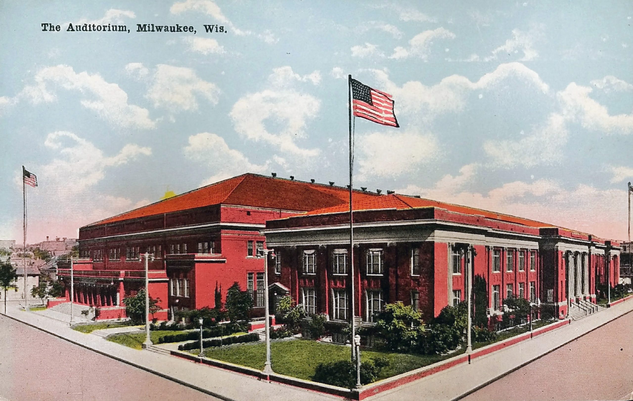
Postcard: Joe Deutsch’s Cafe, Milwaukee, WI

This postcard is not dated or postmarked. This card likely comes from the 1940s or 1950s. It gives the phone number of the restaurant as “Broadway 2-1922,” and the 2L-5N (two-letter, five-number) system for phone numbers began in the 1940s and was phased out starting in 1958. (Ever wonder why telephone dials and keypads have letters over each letter? Now you know! It’s leftover from this mid-20th-Century system of dialing.)

The address for Joe Deutsch’s was 1219 W. Galena St. The place closed in 1954, the building was razed between 1963 and 1971, and this block of Galena Street no longer exists. At one time, Fond Du Lac ran south only to Walnut Street, but in the 1980s, it was extended south into downtown. Today, this spot would be in the middle of the southbound lane of Fond Du Lac as it passes under 12th Street.

Joe Deutsch was a native of Austria, came to Milwaukee in 1912, and began working as a waiter in restaurants. He was employed at the Ogden Cafe and took over the restaurant in 1924 when the owner, Marie Heiser, died. Deutsch sold the Ogden Cafe to John Ernst in 1938. (John Ernst Cafe continued to operate until 2001.) In 1939, Deutsch opened the cafe on Galena and expanded it in 1949, but he closed five years later, in 1954, due to a slump in sales. This place had been popular as a spot for business and labor luncheons and dinners due to its many private dining rooms.

Joe Deutsch didn’t give up. In 1957, he opened the Capitol Lounge in the brand new Capitol Court shopping center. It was the first tavern licensed to operate in a Milwaukee shopping center. In 1958, he opened a new place with his chef, Howard H. Graun, called Deutsch & Graun at 340 West Kilbourn, where Major Goolsby’s is today. In 1966, Graun passed away, and the restaurant became known as Joe Deutsch’s. He leased the space from the Journal Company, and it was known as the city’s second Press Club. In 1970, he sold the business to a company headed by Al McGuire, Marquette’s basketball coach, which was interested in directing it more toward sports fan appeal.

Deutsch died in 1978 at the age of 81.

Sources:

https://en.wikipedia.org/wiki/Telephone_exchange_names

https://0-infoweb-newsbank-com.countycat.mcfls.org/apps/news/openurl?ctx_ver=z39.88-2004&rft_id=info%3Asid/infoweb.newsbank.com&svc_dat=WORLDNEWS&req_dat=0D8DE8DE83992E4A&rft_val_format=info%3Aofi/fmt%3Akev%3Amtx%3Actx&rft_dat=document_id%3Aimage%252Fv2%253A1477BBDEA50EB75C%2540EANX-NB-15A3A4A4B266A36A%25402435108-15A3A46E4403E886%254016-15A3A46E4403E886%2540/hlterms%3AJoe%2520Deutsch%2527s%2520Cafe

https://0-infoweb-newsbank-com.countycat.mcfls.org/apps/news/openurl?ctx_ver=z39.88-2004&rft_id=info%3Asid/infoweb.newsbank.com&svc_dat=WORLDNEWS&req_dat=0D8DE8DE83992E4A&rft_val_format=info%3Aofi/fmt%3Akev%3Amtx%3Actx&rft_dat=document_id%3Aimage%252Fv2%253A119BAA7547AD9B50%2540EANX-NB-16EFB47D0231E112%25402435535-16EF354E8B7ED78E%25409-16EF354E8B7ED78E%2540/hlterms%3AJoe%2520Deutsch%2527s%2520Cafe

https://0-infoweb-newsbank-com.countycat.mcfls.org/apps/news/openurl?ctx_ver=z39.88-2004&rft_id=info%3Asid/infoweb.newsbank.com&svc_dat=WORLDNEWS&req_dat=0D8DE8DE83992E4A&rft_val_format=info%3Aofi/fmt%3Akev%3Amtx%3Actx&rft_dat=document_id%3Aimage%252Fv2%253A119BAA7547AD9B50%2540EANX-NB-16F9DA29355793AA%25402440863-16F9D763034FD5C0%25404-16F9D763034FD5C0%2540/hlterms%3AJoe%2520Deutsch%2527s%2520Cafe

https://0-infoweb-newsbank-com.countycat.mcfls.org/apps/news/openurl?ctx_ver=z39.88-2004&rft_id=info%3Asid/infoweb.newsbank.com&svc_dat=WORLDNEWS&req_dat=0D8DE8DE83992E4A&rft_val_format=info%3Aofi/fmt%3Akev%3Amtx%3Actx&rft_dat=document_id%3Aimage%252Fv2%253A1477BBDEA50EB75C%2540EANX-NB-1588088674DCEEB7%25402440893-15860A3A7A5D313F%254033-15860A3A7A5D313F%2540/hlterms%3AJoe%2520Deutsch%2527s%2520Cafe

https://0-infoweb-newsbank-com.countycat.mcfls.org/apps/news/openurl?ctx_ver=z39.88-2004&rft_id=info%3Asid/infoweb.newsbank.com&svc_dat=WORLDNEWS&req_dat=0D8DE8DE83992E4A&rft_val_format=info%3Aofi/fmt%3Akev%3Amtx%3Actx&rft_dat=document_id%3Aimage%252Fv2%253A1477BBDEA50EB75C%2540EANX-NB-1570F6901B0F8FF0%25402443574-15704082EDED16AC%254033-15704082EDED16AC%2540/hlterms%3AJoe%2520Deutsch%2527s%2520Cafe

Identifier:

PLUS Code: 332F+F4Milwaukee, WI, USA

Postcard: Lake Michigan, Along Lincoln Memorial Drive, Milwaukee, Wis.

This undated postcard must come from around 1950. I’m no automobile expert, but based on the unique grill, that looks like a late 40s Oldsmobile on the left.

Lincoln Memorial Drive opened in 1929. You can see the Lake Front Depot (peeking above the trees) which came down in 1968. And you’ll note that the Eero Saarinen-designed War Memorial building is missing; that opened in 1957.

When Milwaukee was first settled, none of this was land. At the beginning of the 20th century, many city residents wishing to view Lake Michigan were limited to seeing it from either Juneau or Lake Parks. Mansions above the bluffs along N. Prospect Avenue blocked most of the vistas. Sunbathers and swimmers who wanted to go to the small beaches below the bluffs went via one of the parks. Reaching the water from Juneau Park required crossing four sets of railroad tracks.

City councilman wanted residents to have more access, so they secured from the state legislature permission to create a 300-foot-wide strip of lake bed along the shoreline between Juneau and Lake Parks in the 1890s. Between 1917 and 1937, Milwaukee filled in over 77 acres of submerged land to create the downtown lakefront.

You can see a shot of Lincoln Memorial Drive in 1929, and you’ll note how much mature the trees look in this postcard. You can also see the Cudahy Tower being constructed on the far right: http://content.mpl.org/cdm/singleitem/collection/HstoricPho/id/8444/rec/16

In 1929, when the Drive opened, it wasn’t paved the entire way north. You can see the dirt road along Lake Park, next to the old Gun Club (and current rugby field) in this old shot: http://content.mpl.org/cdm/singleitem/collection/HstoricPho/id/8436/rec/8

Sources:

https://i.pinimg.com/originals/c2/5d/ae/c25daebd7d2458b3b0c97c9c3acced9c.jpg

https://urbanmilwaukee.com/2016/05/20/city-streets-lincoln-memorial-dr-was-under-water/

https://mam.org/info/details/war-memorial.php

Identifiers:

PLUS Code: 24V3+59Milwaukee, WI, USA

Approximate Google Street View today: https://goo.gl/maps/EQ6RqfZbRFNq1ZG37

Postcard: Juneau Park, Milwaukee

This old postcard is postmarked 1909. It shows Juneau Park, and although much has changed about the park and lakefront, you can see a couple of familiar things.

In the foreground is the statue Leif, the Discoverer, which still stands today in Juneau Park. The original was unveiled in Boston on October 29, 1887. This replica was erected in Milwaukee two weeks later.

Beyond that, barely visible, is the Juneau Monument. You can see its white base most clearly against the green trees. The sculpture was unveiled on July 6, 1887, by Solomon Juneau’s granddaughter, Hattie White.

The monument commemorates one of Milwaukee’s founders, Solomon Juneau. He settled an area east of the Milwaukee River in 1818. His home and trading post were located where the 100 East Wisconsin Building now stands. He named his settlement Juneau Town. He later joined with George H. Walker’s Walker’s Point and Byron Kilbourn’s Kilbourntown (present-day Westown) to incorporate the City of Milwaukee. Juneau was the postmaster and the first president of the Village of Milwaukee and was elected the first mayor of the City of Milwaukee in 1846. In 1854, Juneau and his family relocated to Dodge County, Wisconsin, where they founded the village of Theresa, named after Juneau’s French-Canadian mother. Solomon died one year later in Keshena, Wisconsin, on a visit to the Menominee tribe.

Of course, there was no Lincoln Memorial Parkway until decades later. By state law, the city had the right to a 300-foot-wide strip of lake bed along the shoreline. In 1907, the massive landfill project that took more than 20 years to complete was started. The work created McKinley and Bradford Beaches as well as a lagoon and a small park around it. Lincoln Memorial Drive connected them all and ran from E. Mason Street to E. Kenwood Boulevard, a distance of slightly over three miles. It opened in 1929 and was named for Abraham Lincoln, whose statue stands in front of the War Memorial today.

In this image, you see Chicago & Northwestern Railroad tracks and, in the distance, the old Chicago & Northwestern Railway Depot on Wisconsin Avenue. This building was razed in 1966.

Sources:

https://siris-artinventories.si.edu/ipac20/ipac.jsp?&profile=all&source=~!siartinventories&uri=full=3100001~!19118~!0

https://archive.org/details/wpaguidetowiscon0000unse/page/259

https://en.wikipedia.org/wiki/Juneau_Monument

https://siris-artinventories.si.edu/ipac20/ipac.jsp?&profile=all&source=~!siartinventories&uri=full=3100001~!27381~!0#focus

https://archive.org/stream/unveilingjuneau00junegoog#page/n24/mode/2up

http://www.wisconsinhistoricalmarkers.com/2014/10/solomon-juneau-monument.html

https://urbanmilwaukee.com/2016/05/20/city-streets-lincoln-memorial-dr-was-under-water/

Postcard: “Downtown” View of Milwaukee, Wis.

Here is a great, undated postcard of Milwaukee from the air. You can see many of downtown’s oldest buildings here. This view is from the 1930s or 1940s. The postcard contains the Centre Building (barely visible near 2nd and Wisconsin), which was built in 1931, but is missing the two-story Art Moderne parking garage Gimbels constructed in 1947 on the corner of Michigan and Plankinton.

On the top right is the City Hall (1895 to present).

Below and to the left of City Hall (with two large vertical signs) is the First Wisconsin National Bank Building (1914 to present). Below that is the distinctive Pabst Building (1892 to 1981). To the east (right) of the Pabst, the tall, white building with two wings is the Bankers Building, constructed in 1929 and still standing today as the Drury Plaza Hotel. South of the Pabst, along the east (right) side of the river, is a block of small buildings that were razed between 1959 to 1961 to make way for the Marine Bank building, including the Mack Block Building, National Exchange Bank, and Bradley Building.

On the right side of the postcard, midway from top to bottom, you can see a tall, thin, red building–that’s the Railway Exchange Building that still stands on Broadway and Wisconsin. Just south of the Railway Exchange building and north of Michigan Street is the Loyalty Building, built in 1886 as the second headquarters of Northwestern Mutual Life.

To the south of that, across Michigan (and right above label “‘Downtown’ View of Milwaukee, Wis.”) is the Chamber of Commerce Building or Mackie Building. You can see its distinctive tower. The ornate building was built in 1880 and still stands. To the left of that, the red building is the Mitchell Building (1878 to present).

A block south of that, to the left of the postcard label, is the Button Block building on Clybourn (once known as Huron St). It was built in 1892 and still stands today. It has had a number of clubs and restaurants on the first floor, from Park Avenue to Brett Favre’s Steakhouse. Today, it is the Homewood Suites.

Across the river you can see the buildings that comprised Gimbels–the northern part along Wisconsin Avenue built in 1923 and the southern portion along Michigan Avenue in 1920. Both still stand today. Peeking over Gimbels, on the north side of Wisconsin between Plankinton and the river, you can see the Empire Building, built in 1928. That still exists and houses the Riverside Theater.

The large, white, block-long building to the west (left) of Gimbels is the Plankinton Arcade. This is how it looked after 1925, when an additional five floors were added to the original two-story building. In the same block, south of the Plankinton Arcade, you can see two buildings that no longer exist. On the corner of Michigan And Plankinton, the large, red, eight-story building is the Plankinton Hotel (1917 to 1980). (I actually got to see a portion of this come down while visiting downtown with my folks.) And along 2nd Street, to the north of the surface parking lot, is the 11-story Hotel Antlers.

A block north of the Plankinton Arcade, you can see eight-story, five-sided Brumder Building or Germania Building. It has a bit of an odd shape to match the block it’s on and features four distinctive covered domes in the shape of Kaiser helmets on its roof. It was originally named the Germania Building, but they changed the name during WWII in honor of the owner, George Brumder (and to obscure the German reference). That was built in 1896 and still stands today.

Above the Germania Building, you can see another building that still stands today. The reddish/brown, nine-story Chalet At The River Building. It was built as a six-story building in 1908, and the top three floors added in 1913. To the left of that is a white building called the Century Building. It was built in 1925 and had Radio Doctors on the first floor from 1961 to 1991.

And, finally, in far upper left corner, you see the Milwaukee Auditorium (now known as the Miller High Life Theatre.) In 1950, the Milwaukee Arena would be built to the east of the Auditorium.

Identifier:

Approximate Google Earth View today:

https://earth.google.com/web/@43.0374909,-87.90949003,213.44860423a,471.22914979d,35y,-25.72727653h,67.59908915t,0r

Postcard: Whaleback Steamer Christopher Columbus, Chicago to Milwaukee

This is not a Milwaukee building, but it’s interesting nonetheless. This undated postcard shows the Christopher Columbus whaleback steamer. SS Christopher Columbus was the only whaleback ship ever built for passenger service, the longest whaleback ever built (at 362 feet), and reportedly also the largest vessel on the Great Lakes when she was launched.

The World’s Fair Steamship Company ordered the boat to ferry passengers to the Columbia Exposition (hence the name of the boat.) She was elegantly furnished. Her grand saloon and skylighted promenade deck contained several fountains and a large aquarium filled with trout and other fish of the lakes. The cabins and public spaces were fitted out with oak paneling, velvet carpets, etched glass windows, leather furniture, and marble. Shops and restaurants were provided for the passengers.

The ship was built for speed, making the six-mile run from Chicago’s downtown to the Jackson Park site of the Exposition in under 20 minutes. She had an estimated capacity of 4,000–5,000 passengers on her four decks, but it was reported that she carried 7,000 on her maiden voyage. The Columbus carried between 1.7 and 2.0 million passengers during the exposition, with only one fatality, a crew member. After the exposition ended the Columbus entered passenger service.

The boat had at least four accidents. In June 1895, on just the second day of its summer ferry season, the Christopher Columbus suffered an explosion caused by a steam pipe becoming disconnected while she was underway, enveloping the ship in a cloud of blistering steam. The accident happened, it was reported, while racing with a rival ship, the Virginia of the Goodrich Line, from Milwaukee to Chicago, although its captain denied the claim. Thirteen people were injured.

In 1896, she struck the Buffalo Street swing bridge in Milwaukee. Swing bridges open by spinning horizontally from a pier in the middle of the river. The bridge was three-quarters open and had 75 people on it to watch the boat pass when the accident happened. The bridge was displaced three feet, and had it moved another six inches, it would have fallen into the river. The City attempted to stop the boat from navigating so far upriver but eventually realized it didn’t have the authority because the river was under control of the war department.

In June 1905, as the Christopher Columbus was being towed out of the Chicago River, she collided with the schooner Ralph Campbell. It suffered no damage.

And in 1917, the boat had its most serious accident. Recent floods made the Milwaukee River unusual treacherous, causing the ship to collide with a water tower. The tower topped and flooded the Columbus’ decks with about 25,000 gallons of water. The collision killed 15, 16 or 18 passengers, by various accounts. Milwaukee police estimated 20,000 Milwaukeeans flocked to the river the following day to watch “the grewsome search for bodies.”

She was scrapped in 1936.

Source:

https://en.wikipedia.org/wiki/SS_Christopher_Columbus

https://greatlakes.bgsu.edu/item/434499

http://www.gendisasters.com/illinois/6431/waukegan-il-steamer-christopher-columbus-serious-accident-june-1895

https://0-infoweb-newsbank-com.countycat.mcfls.org/apps/news/openurl?ctx_ver=z39.88-2004&rft_id=info%3Asid/infoweb.newsbank.com&svc_dat=WORLDNEWS&req_dat=0D8DE8DE83992E4A&rft_val_format=info%3Aofi/fmt%3Akev%3Amtx%3Actx&rft_dat=document_id%3Aimage%252Fv2%253A1477BBDEA50EB75C%2540EANX-NB-164BC1606E4B10B3%25402413776-164A28536B519EDE%25400-164A28536B519EDE%2540/hlterms%3A%2522Christopher%2520Columbus%2522%2520%2520bridge

https://books.google.com/books?id=HDYZAAAAYAAJ&lpg=PA378&ots=qqFBgGHFBt&dq=%22Christopher%20Columbus%22%20%22Ralph%20Campbell%22&pg=PA378#v=onepage&q=%22Christopher%20Columbus%22%20%22Ralph%20Campbell%22&f=false

https://0-infoweb-newsbank-com.countycat.mcfls.org/apps/news/openurl?ctx_ver=z39.88-2004&rft_id=info%3Asid/infoweb.newsbank.com&svc_dat=WORLDNEWS&req_dat=0D8DE8DE83992E4A&rft_val_format=info%3Aofi/fmt%3Akev%3Amtx%3Actx&rft_dat=document_id%3Aimage%252Fv2%253A119BAA7547AD9B50%2540EANX-NB-16CCAFEE8EF514B1%25402421412-16CC3A13AED6E642%25402-16CC3A13AED6E642%2540/hlterms%3A%2522Christopher%2520Columbus%2522

https://0-infoweb-newsbank-com.countycat.mcfls.org/apps/news/openurl?ctx_ver=z39.88-2004&rft_id=info%3Asid/infoweb.newsbank.com&svc_dat=WORLDNEWS&req_dat=0D8DE8DE83992E4A&rft_val_format=info%3Aofi/fmt%3Akev%3Amtx%3Actx&rft_dat=document_id%3Aimage%252Fv2%253A119BAA7547AD9B50%2540EANX-NB-16CCAFEE8EF514B1%25402421412-16CC80960CC33102%25400-16CC80960CC33102%2540/hlterms%3A%2522Christopher%2520Columbus%2522

https://0-infoweb-newsbank-com.countycat.mcfls.org/apps/news/openurl?ctx_ver=z39.88-2004&rft_id=info%3Asid/infoweb.newsbank.com&svc_dat=WORLDNEWS&req_dat=0D8DE8DE83992E4A&rft_val_format=info%3Aofi/fmt%3Akev%3Amtx%3Actx&rft_dat=document_id%3Aimage%252Fv2%253A119BAA7547AD9B50%2540EANX-NB-16DFE03D542C1BB4%25402426703-16DDBB755248D031%254041-16DDBB755248D031%2540/hlterms%3A%2522Christopher%2520Columbus%2522%2520%2520%2522water%2520tower%2522

https://www.wisconsinhistory.org/Records/Image/IM4685

Postcard: Grand Ave. Bascule Bridge, Milwaukee

This postcard, postmarked 1907, shows a boat passing the Grand Avenue (now Wisconsin Avenue) Bascule bridge. (A bascule bridge is just a fancy name for a drawbridge).

This bridge would have been fairly new at the time this image was captured. A swing bridge, which pivoted horizontally from a piling in the center of the river, was replaced with this bridge in 1902. The old swing bridge was moved six blocks north to Chestnut Street, which is now called Juneau Avenue. In 1901, the city received four bids to build this bridge, ranging from $84,700 to $103,486 for an “ornamental structure.” (Those figures would be equal to $2.5M to $3.1M today.)

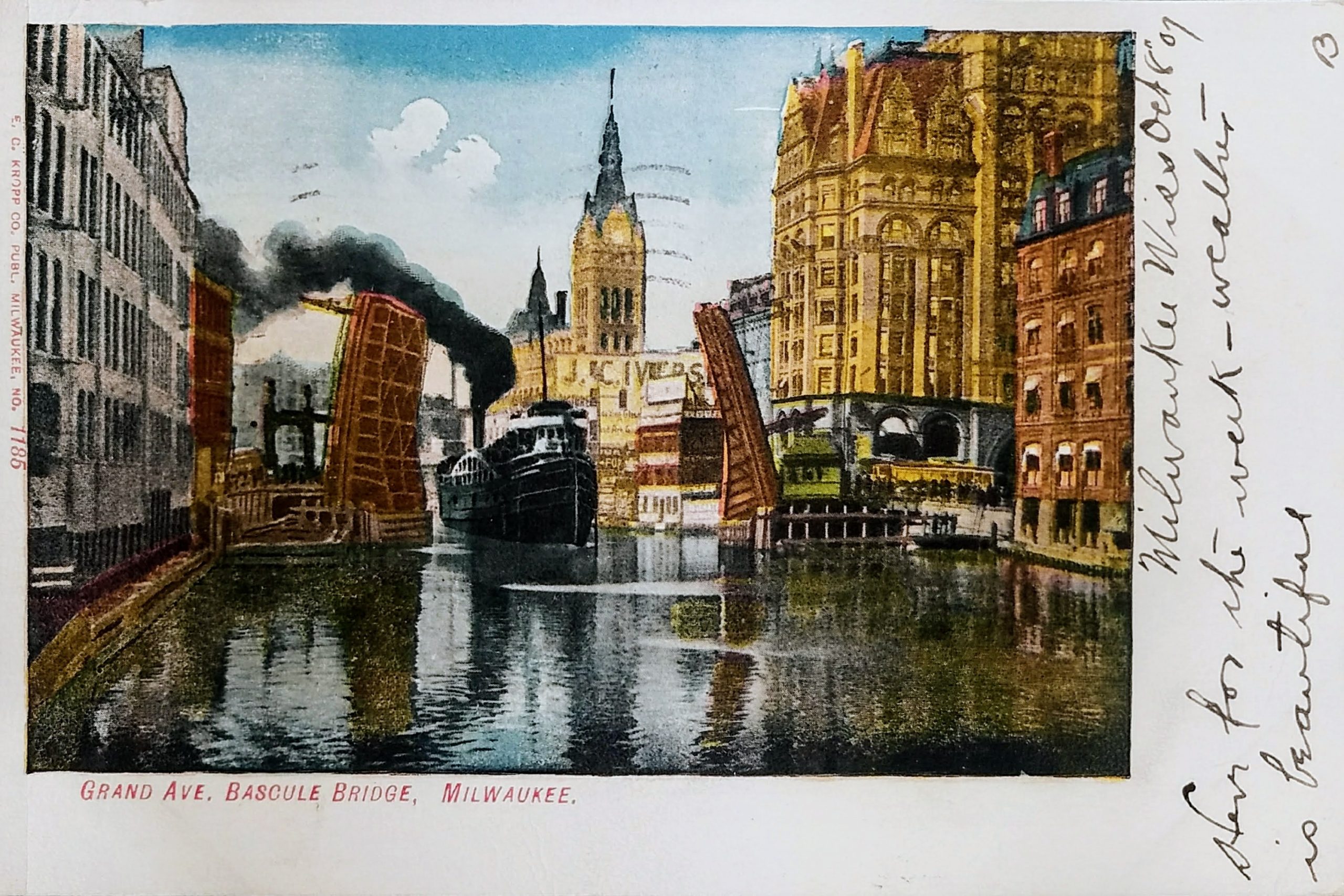
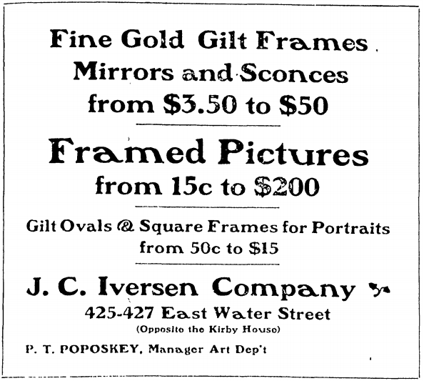
Just over the bow of the ship, you can see the J. C. Iversen building. John C. Iversen established his picture-framing business in 1867 on Spring Street (later Grand Avenue). The business prospered and expanded in 1879 to this five-story building you see here on E. Water Street (now N. Water Street).
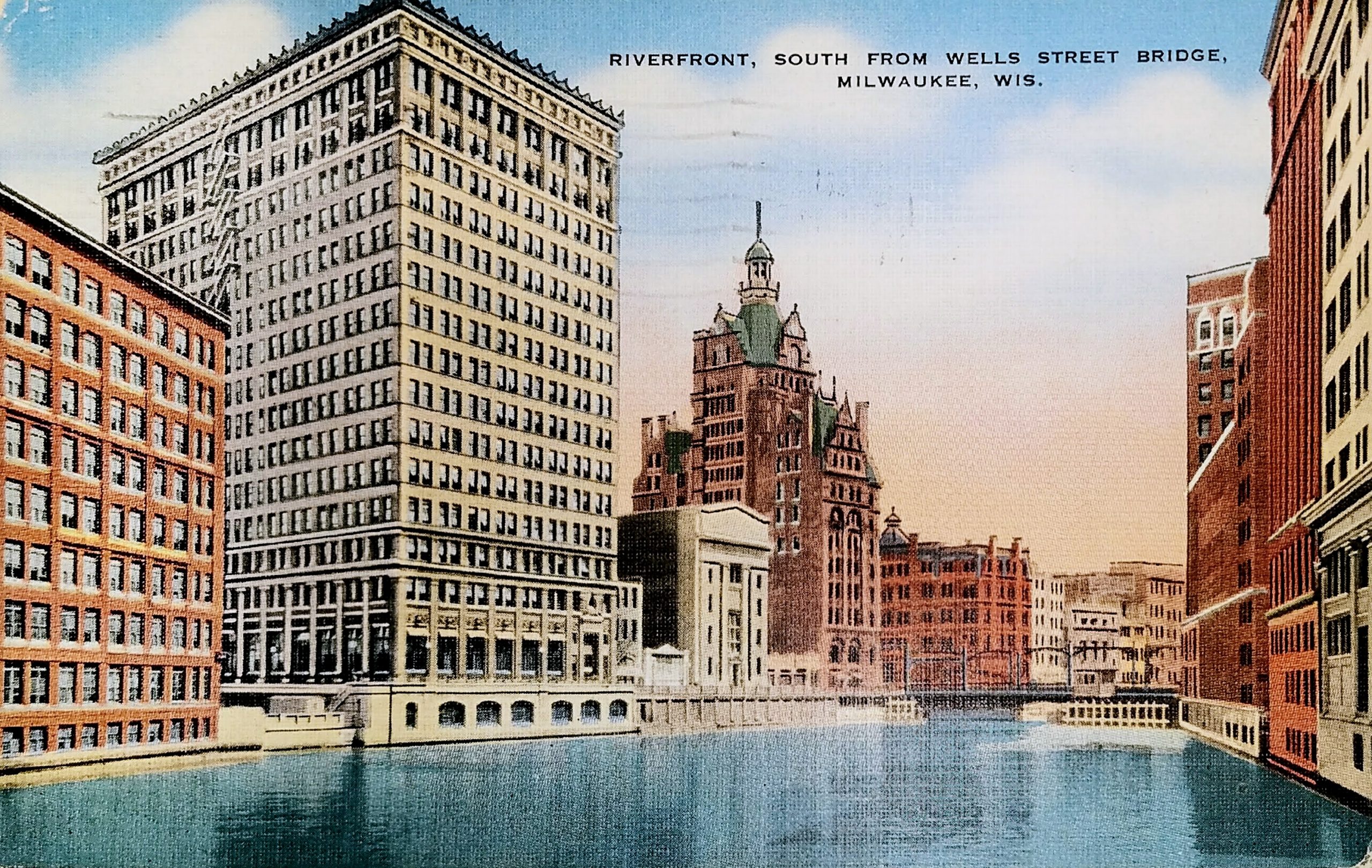
On the left, you see the old four-story Gimbel’s building that was razed to make way for the new eight-story building in the 1920s. (At the top, you can see the last two letters of the Gimbel’s name.)

In the center is, of course, City Hall. To the right is the Pabst Building and Mack Block Building, across from each other on what is now Wisconsin Avenue.

I think the only thing visible in this image that still stands is city hall.

Sources:

https://www.milwaukeeriverkeeper.org/milwaukee-bridge-history/

https://0-infoweb-newsbank-com.countycat.mcfls.org/apps/news/openurl?ctx_ver=z39.88-2004&rft_id=info%3Asid/infoweb.newsbank.com&svc_dat=WORLDNEWS&req_dat=0D8DE8DE83992E4A&rft_val_format=info%3Aofi/fmt%3Akev%3Amtx%3Actx&rft_dat=document_id%3Aimage%252Fv2%253A1477BBDEA50EB75C%2540EANX-NB-164DEAC1C4CECCC1%25402415547-164DC1903029B0C5%25402-164DC1903029B0C5%2540/hlterms%3A%2522Grand%2520Ave%2522%2520%2522bascule%2520bridge%2522

https://0-infoweb-newsbank-com.countycat.mcfls.org/apps/news/openurl?ctx_ver=z39.88-2004&rft_id=info%3Asid/infoweb.newsbank.com&svc_dat=WORLDNEWS&req_dat=0D8DE8DE83992E4A&rft_val_format=info%3Aofi/fmt%3Akev%3Amtx%3Actx&rft_dat=document_id%3Aimage%252Fv2%253A1477BBDEA50EB75C%2540EANX-NB-164E0FE9181E1E4F%25402415501-164C78C7C2ACFAF7%25400-164C78C7C2ACFAF7%2540/hlterms%3A%2522Grand%2520Ave%2522%2520%2522bascule%2520bridge%2522

http://bridgehunter.com/wi/milwaukee/B40048800000000/

https://milwaukeehistory.net/wp-content/uploads/2018/05/2008.J.C.-Iversen-Co.pdf

https://urbanmilwaukee.com/2015/06/16/yesterdays-milwaukee-j-c-iverson-co-about-1879/

Identifiers:

PLUS Code: 23PQ+XW Milwaukee, Wisconsin

Approximate Google Street View today: https://goo.gl/maps/d4twmHVXbdjWXVwM7

Postcard: Riverfront, South from Wells Street Bridge, Milwaukee, Wis.

Postmarked 1940, this postcard shows the Milwaukee River looking south from the Wells Street Bridge.

On the far left is the 8-story Manufacturers Home Building, built in 1909. It was converted to apartments in 1997 and is currently known as “City Hall Square.” This building was home to the Central Continuation School, which eventually evolved into the Milwaukee Area Technical College. A 1919 publication noted that the school for girls was located here and could accommodate “about 5000 girls.” In the 1920s, the school moved to new facilities on 6th and State Streets where MATC is still located today.

Across Mason Street is the 16-story First Wisconsin National Bank, built in 1914. The building was home for the First Wisconsin Bank until the 42-story tower opened on East Wisconsin Ave in 1973.

The four-story neo-classic building nest to that is Marshall & Ilsley Bank, built in 1913. An additional two stories were added in 1930. The building was demolished in 1981 to make room for the 100 East Wisconsin building.

South of that, on Wisconsin Ave, is Milwaukee’s first skyscraper, the Pabst Building (1892 to 1981).

Sources:

https://books.google.com/books?id=JsUBAAAAYAAJ&lpg=PA609&ots=oQIQI3oqxj&dq=Central%20Continuation%20School%20manufacturer’s%20home%20buildnig&pg=PA609#v=onepage&q=Central%20Continuation%20School%20manufacturer’s%20home%20buildnig&f=false

Identifiers:

PLUS Code: 23RQ+47 Milwaukee, Wisconsin

Approximate Google Street View today: https://goo.gl/maps/zCzNooupmvNkZite7

Bowling History of Windup Lanes

From the West Allis Star of APRIL 29, 1954

Carl Ray Jr is one of the bowlers memorialized in the Milwaukee Bowling Hall of Fame. He recently passed away in December 2019. At the age of 18 he was in the All Star League and at 22 became the manager of the Windup Lanes. The above article states that he started his first Tournament of Champions in 1954 at the Windup Lanes.

Postcard: Lake Park and Drive, Milwaukee

Today’s Lake Park is hardly recognizable in this postcard. It’s difficult to imagine the park with so few trees, isn’t it? This image depicts the park around 1900, after the Lion Bridges were complete but before other park facilities were added in the first decade of the 20th century.

The roadway pictured on the left portion of the postcard is now a pedestrian trail called the Oak Leaf Trail. The road in the upper right portion is today the Lake Park Road that leads to the Lake Park Bistro parking lot. The two “Lion Bridges” on either side of the lighthouse were constructed in 1896-97. In 1964, the bridges were narrowed and closed to vehicles. Today, that fountain between the bridges is gone, but you can still see the semicircular chain fence that remains.

The lighthouse is the North Point Lighthouse. The original lighthouse was built in 1855 but had to be abandoned because of bluff erosion. This lighthouse was built 100 feet further inland and began use in 1888. In 1907, the lighthouse began operating locally after Congress ceased funding due to trees and city lights obscuring the beacon.

The image shows the lighthouse at its 1888 height of 39 feet. In 1912, a new steel structure with the old iron tower attached on top raised the beacon to 74 feet from the ground. That is the lighthouse you can visit today. The U.S. Coast Guard decommissioned it in 1994.

Although the postcard is undated, it has a divided back, which means it was printed after 1907, but the image seems to reflect how Lake Park looked roughly a decade earlier. There are no trees growing to obscure the lighthouse. Also, by 1899, a horse barn (not pictured) was opened. In 1903 a 6-hole golf course was created just north of the lighthouse (also not pictured) and the pavilion (which today houses Lake Park Bistro) opened beyond that first bend of the roadway. Lake Park’s famous grand staircase, leading from landfill at the shore to the pavilion would come later, in 1908.

Lake Park was designed by Frederick Law Olmsted. He was the landscape architect responsible for Central Park in New York City and the grounds of Chicago’s Columbia Exposition.

At the time of this postcard, the bluff fell directly into the lake. Since then, landfill has been used to extend the shore for Lincoln Memorial Drive and the parks on Milwaukee’s lakeshore.

Roughly where those ships rest at the dock is where the Milwaukee Gun Club once had a shooting range on land created by the landfill. The gun club received a license for the land in 1928, but for five decades the county fought to evict the club, seeking to use the space for general park activity. The club agreed to move, then renigged on the promise, and finally went to court to try to keep the land. In 1992, after losing their case, the gun club finally agreed to abandon the site. Today, a rugby field is located approximately at this spot along the lakefront.

Sources:

http://lakeparkfriends.org/history/map/

https://bridgehunter.com/wi/milwaukee/bh36758/

https://0-infoweb-newsbank-com.countycat.mcfls.org/apps/news/openurl?ctx_ver=z39.88-2004&rft_id=info%3Asid/infoweb.newsbank.com&svc_dat=WORLDNEWS&req_dat=0D8DE8DE83992E4A&rft_val_format=info%3Aofi/fmt%3Akev%3Amtx%3Actx&rft_dat=document_id%3Anews%252F0EB827495B817888

https://0-infoweb-newsbank-com.countycat.mcfls.org/apps/news/openurl?ctx_ver=z39.88-2004&rft_id=info%3Asid/infoweb.newsbank.com&svc_dat=WORLDNEWS&req_dat=0D8DE8DE83992E4A&rft_val_format=info%3Aofi/fmt%3Akev%3Amtx%3Actx&rft_dat=document_id%3Aimage%252Fv2%253A119BAA7547AD9B50%2540EANX-NB-17006BF9D599BC0F%25402448953-1700333EC503132B%25406-1700333EC503132B%2540/hlterms%3AMilwaukee%2520%2522gun%2520club%2522%2520%2522lincoln%2520memorial%2520drive%2522

Identifiers:

PLUS Code for North Point lighthouse: 348H+7C Milwaukee, Wisconsin

Approximate Google Earth view today: https://earth.google.com/web/@43.06667998,-87.86961156,215.67551459a,406.4992602d,35y,27.93091114h,86.94008376t,360r

Postcard: Whaleback Steamer “Christopher Columbus” passing Buffalo St. Bridge

This undated postcard shows the Christopher Columbus passing the Buffalo St Bridge. Neither the boat nor the bridge exist any longer. This photo likely comes from the 1920s or early 1930s.

SS Christopher Columbus was the only whaleback ship ever built for passenger service. The ship was the longest whaleback ever built, and reportedly also the largest vessel on the Great Lakes when she was launched. She served as an excursion liner on the Great Lakes between 1893 and 1933 and began life shuttling visitors from downtown Chicago to the World’s Columbian Exposition. The ship could carry 4,000 to 5,000 passengers on her four decks, but it was reported that she carried 7,000 on her maiden voyage. She was scrapped in 1936.

The bridge at Buffalo Street was originally a swing bridge that pivoted on a center pier. In 1896, the Christopher Columbus hit the bridge, severely damaging the bridge. The draw bridge pictured here replaced the swing bridge in 1914. (That poor ship had its problems–in 1917, it collided with a water tower near Michigan Street in Milwaukee, sending the tower crashing onto the ship and killing passengers.)

The Buffalo Street bridge was removed in the late 1970s after the construction of the bridge over the river at St. Paul Avenue.

Sources:

https://en.wikipedia.org/wiki/SS_Christopher_Columbus

https://chicagology.com/columbiaexpo/fair080/

https://urbanmilwaukee.com/2016/01/22/city-streets-buffalo-st-was-where-black-man-lynched/

Identifiers:

PLUS Code: 23MQ+MM Milwaukee, Wisconsin

Approximate Google Street View today: https://goo.gl/maps/Gv1La3RLXYnqybLc6