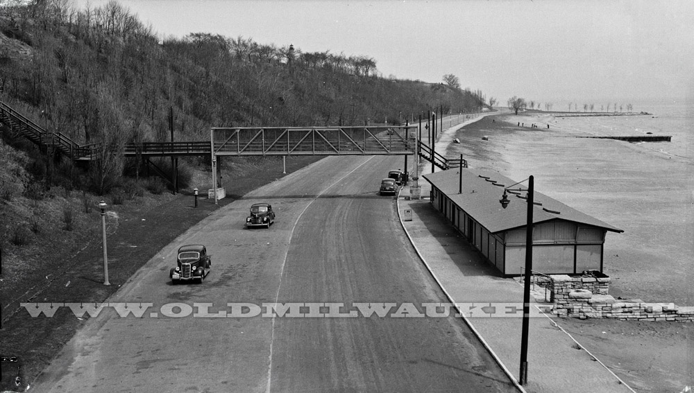
This 1941 photo looks north on Lincoln Memorial Drive at Bradford Beach. The final section of the Drive which connected to Kenwood Boulevard officially opened on September 28, 1929. One interesting side note of the Drive extension to Kenwood is that it displaced a popular free tourist camp on the bluff overlooking the lake at the east end of Kenwood that had operated in the 1920’s. Car camping was a newfound past-time and several thousand people per year would stop and camp there.
Bradford Beach was given the name because it lay directly east of Bradford Avenue. Bradford Beach had been a popular swimming spot for many years prior and was usually accessed by walking down from the bluff or along the lake from further south. Prior to the opening of Lincoln Memorial Drive, Bradford Beach wasn’t too easy to get to by car. The only road was a narrow dirt and sand road so most people walked there from McKinley Beach. Until 1921, McKinley was the preferred spot. It was closer to where most people lived. Polluted water pushed more people further north to the cleaner beach at the foot of Bradford Avenue. On really hot days, both beaches were crowded.
The building shown housed a refreshment stand and changing rooms. It was built in 1927 and lasted until the one that we all know was built in 1949. The current Bath House is an amazing mid-century building that is described as:
Shaped like a ship, this pavilion seems ideally suited to its location on a popular swimming beach. The city built the bathhouse to provide restroom, changing, and bathing facilities. Architects Grunwald and Behrens decked out the two-story, brick and concrete structure with maritime motifs. The upper story opens onto a ship-like promenade deck. The enclosed lower story resembles a ship’s hull, perforated only by doors and glass-block ribbon windows. A curving prow forms the front of the pavilion, and a flagpole rises like a mast. A long, rail-enclosed sundeck trails off to the stern, its twisting staircase descending to the beach.
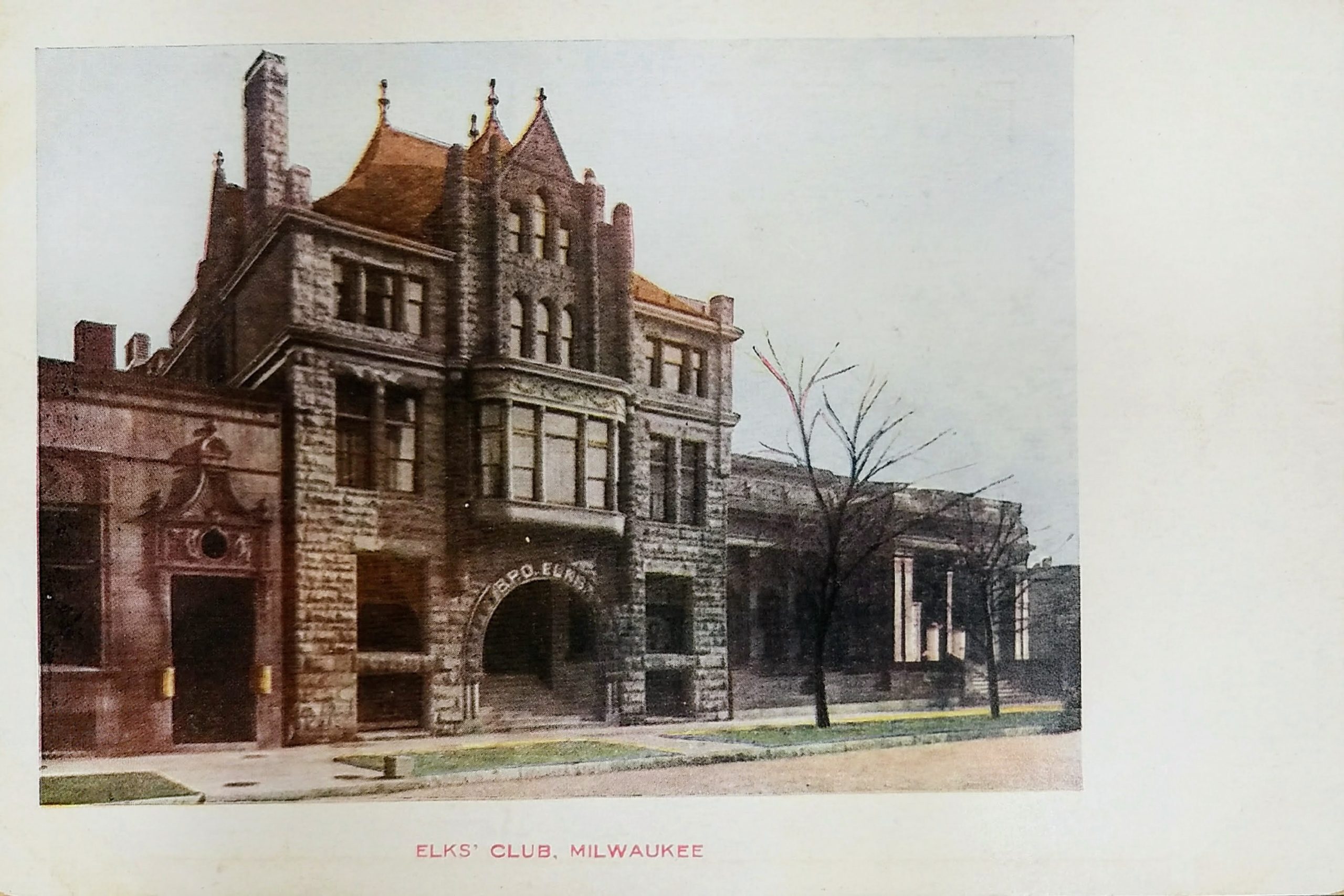
This postcard is not postmarked but predates 1907 (since it has an undivided back). The Elk’s Club was located on the east side of Jefferson between Mason and Wells. Today, that spot is occupied by the block-long Office on the Square building.
The building in this postcard was originally the home of the Phoenix Club. The Elks Club, which was established in 1886, bought and occupied it from 1906 until 1925 when they moved to a huge new building on Mason and Prospect. In 1928, this became the Moose Club building. The building suffered a major five-alarm fire in 1955, was remodeled and reopened, but was razed two years later after another three-alarm fire.
The building to the right is the Layton Art Gallery. It was a donation to the city by philanthropist Frederick Layton. It was built in 1888 and demolished in 1957. In 1957, the gallery merged with the Milwaukee Art Institute, forming the Milwaukee Art Center, and moved to the Milwaukee County War Memorial Center.
The building you can barely see to the left became the Milwaukee Art Institute, but when this photo was taken, it was still the Land, Log, and Lumber Company. It was built in 1893 as a one-story office and was bought in 1911 to house the Milwaukee Art Institute. An extra floor was added in 1921. This building, like the others on the block, was demolished in 1957, but pieces of the facade were salvaged and re-used as decorations in the interior of the Office on the Square building.
This undated postcard shows a block of buildings along Broadway that no longer exists. This view is facing south from Mason toward Wisconsin Avenue. The tall building with the tower is the Railway Exchange Building, built in 1901 and still standing today. Everything to the right of that, however, is gone. Presently, the Two-Fifty Building (250 East Wisconsin) and its parking garage occupy this block.
The first building on the end of the block, the five-story structure across Wisconsin from the Railway Exchange Building, is the Broadway Building, Northwestern Mutual Life’s first office from 1870 to 1885. It was built in 1870 with a mansard roof, but this was partially burned in a fire in 1901 and rebuilt to make a complete floor. In 1940, the building was cut down to two floors and was eventually demolished in 1965.
On the far right, the four-story building with the two curved awnings at street level is the Herold Building. It was built in 1861 as the Bentley European Hotel, bought by the Herold in 1875 and renovated for Herold publisher, William Coleman. The Herold was a German-language newspaper.
In 1885, the Milwaukee Press Club was formed following a meeting in the Herold Building, and it served as the Club’s first offices. The Milwaukee Press Club is the oldest continuously operating press club in North America, and possibly the world. The building was demolished in 1941.
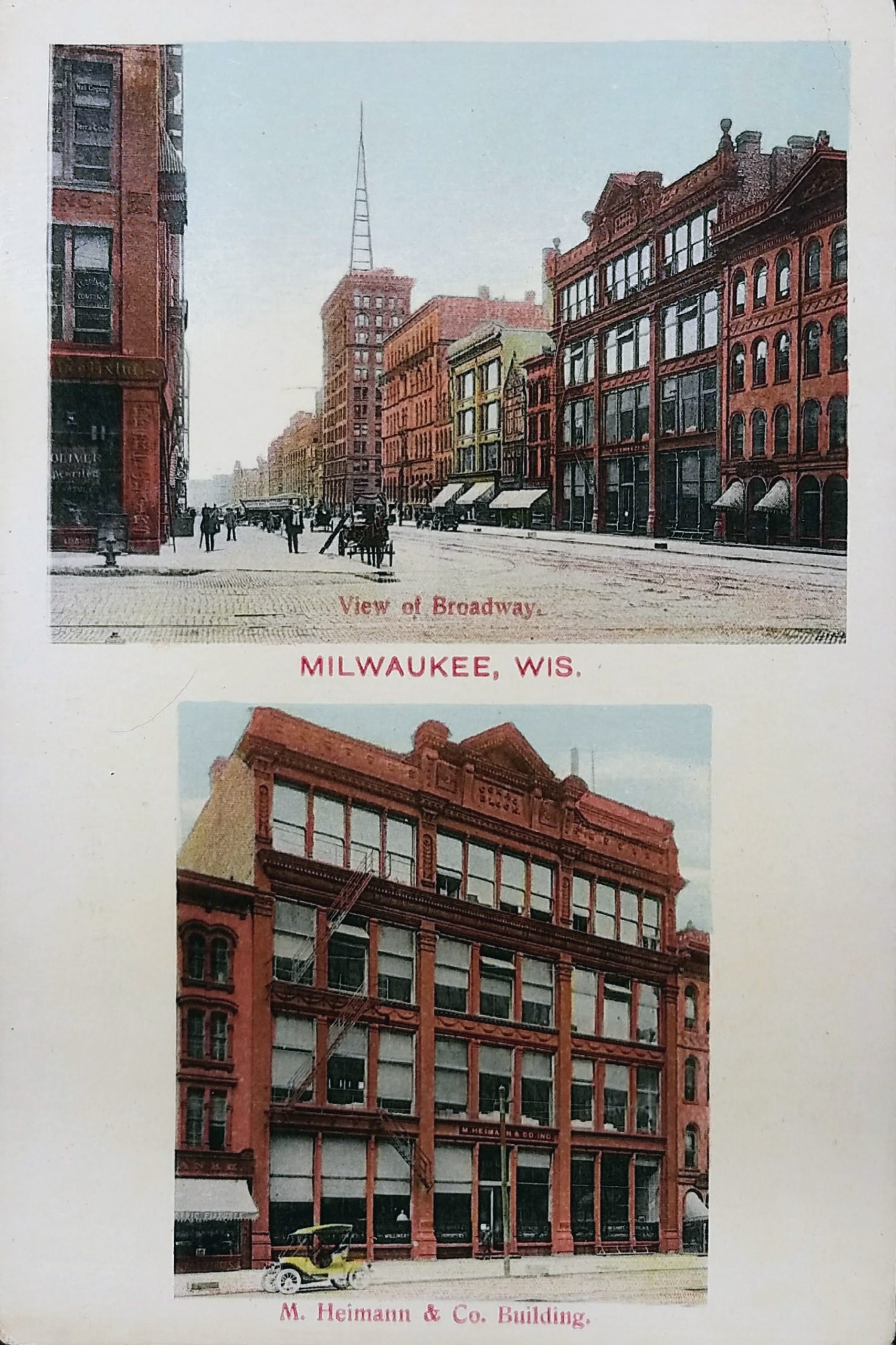
The M. Heimann & Co. Building is featured on the lower half of this postcard. The company launched in 1857 on E. Water Street and moved here in 1872. The business was “exclusively millinery” (makers of hats) and in 1881 it was “one of the largest wholesale houses in the northwest,” employing “ten men in the store” and “125 persons in the house daily, including ladies engaged in manufacturing flowers.” In 1881, the business reported trade of $300,000 to $400,000 per annum, which would be roughly $8 to $10 million in 2020 dollars.
This building was destroyed in a terrible fire in 1918. The blaze was so serious “a repetition of the Third Ward conflagration seemed imminent.” The Sentinel reported that the fire “threatened for a time to destroy the entire block.” (The October 15, 1918 edition that reported on the fire was “issued under extreme difficulties” since the newspaper’s officers were in the Herold building, adjacent to the Heimann Building, and were damaged in the fire.) Two firefighters and two spectators were hurt during the blaze.
This site has been a public gathering spot for Milwaukeeans since the earliest years of the city. In 1835, Byron Kilbourn bequeathed the land to the city with the stipulation it be used as public grounds, house a public marketplace, and a specific part would never be built upon. In 1867, Market Hall, a small arcade was built on the site.
Market Hall was torn down in 1880, and the land was given in a 50-year lease to the Milwaukee Industrial Exposition Association in order to build an exposition hall for the city. The Kilbourn family brought an injunction against the city for using the land for non-public use, but the city obtained their permission for the structure. In 1881, a grand Exposition Hall was opened at this location. The hall had the first electric lights in a public building in Milwaukee and featured a large pipe organ, an art gallery, and was the first home of the Milwaukee Public Museum. The building burned down while hosting a card tournament in June of 1905.
Plans began immediately to replace the Exposition Hall with an auditorium. Some of Kilbourn’s heirs continued to protest that the use of the property would not be purely public; eventually, the Supreme Court ruled that the Auditorium fulfilled the stipulations of Byron Kilbourn’s donation. Since then, his heirs have not disputed the use of the land. The Milwaukee Auditorium opened on September 21, 1909.
On October 14, 1912, former president and then-current presidential candidate Theodore Roosevelt delivered a speech at the Milwaukee Auditorium shortly after a failed assassination attempt that left him with a bullet in his chest. He was shot a block away from the Auditorium at the Gilpatrick Hotel but declined to go to the hospital before giving his speech. The bullet lodged in Roosevelt’s chest only after hitting both his steel eyeglass case and a 50-page copy of his speech.
Roosevelt began his speech by saying, “Friends, I shall ask you to be as quiet as possible. I don’t know whether you fully understand that I have just been shot.” He delivered his scheduled speech with blood seeping into his shirt and spoke for 90 minutes. An X-ray showed that the bullet had lodged in Roosevelt’s chest muscle but did not penetrate the pleura. Doctors concluded that it would be less dangerous to leave it in place than to attempt to remove it, and Roosevelt carried the bullet with him for the rest of his life. He died seven years later.
Roosevelt’s would-be assassin was John Schrank, an unemployed New York City saloonkeeper who had stalked his prey around the country for weeks. He had dreamt that President McKinley sat up in his coffin, pointed at Theodore Roosevelt, called him a murderer, and demanded his death be avenged. (McKinley was assassinated in 1901 by an anarchist.) Schrank pled guilty, was determined to be insane, and spent 29 years in the Central State Hospital for the Criminally Insane in Waupun, Wisconsin before dying in 1943.
The Auditorium was the site of other controversial and newsworthy happenings. During the influenza epidemic of 1917 and 1918, the Auditorium instigated “influenza seating;” rows were spaced widely, and monitors sat at the ends to catch signs of sickness. When the sickness was at its height, the building became a hospital to care for the afflicted.
In the 1920s, the Ku Klux Klan wanted to have a rally in the building “to teach law and order.” Mayor Daniel W. Hoan wrote back, “you come here and touch a hair on the head of one Catholic, one Jew, one chiropractor, or one anything else, and I’ll make this the hottest place this side of hell for the Ku Klux Klan.” In 1938, a German group was not allowed to meet in the structure because of tension caused by World War II (despite Milwaukee’s deep German heritage).
The theater has hosted many of the nation’s most famous artists. Opera stars Geraldine Farrar, Olga Samaroff and Enrico Caruso performed on stage. So did John Philip Sousa and Louis Armstrong. In 1948, the Polka King contest crowned legendary Frankie Yankovic and Four Cleveland Kids as the best polka band. In the 1960s and 1970s, the list of artists who performed here included Herman’s Hermits, Lou Reed, Santana, Frank Zappa, The Kinks, Rush, The Grateful Dead, Bob Dylan, Alice Cooper, Kiss, and Phil Collins.
To the right, you see 5th Street. The Auditorium Annex housed the original front façade along Fifth Street. The street was closed when the Arena was built next door in 1950, and today the front entrance is on Kilbourn.
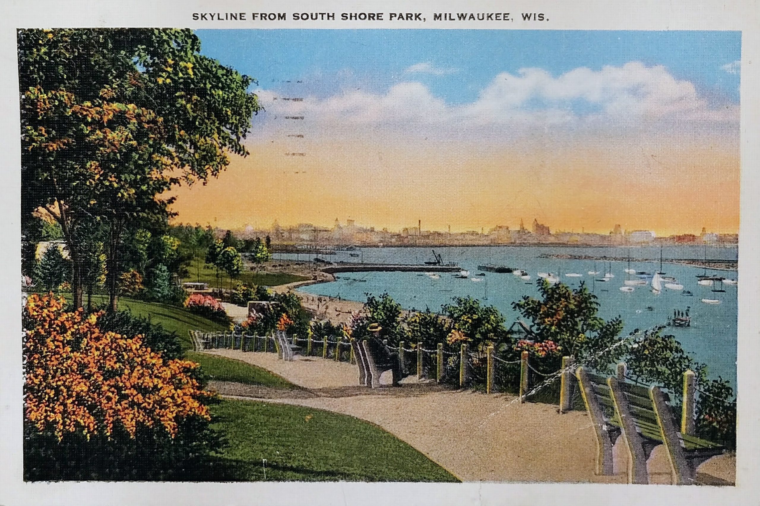
This postcard is postmarked 1937. It shows a lovely view of the Milwaukee harbor and skyline from South Shore Park in the 1930s.
The land for the South Shore Park was originally part of the farm of Bay View pioneer Elijah Stone Estes. Estes moved from North Carolina because he abhorred the slavery that was prevalent in the state. He stopped in Chicago and then headed north to claim land south of Milwaukee. Estes’ 150-acre holding ran from the lakeshore to the east, the Chicago & Northwestern track to the west, today’s Nock Street on the north, and the St. Francis Seminary on the south.
The land for 47-acre South Shore Park was acquired between 1909 and 1929. The first 15.32 acres of the park were purchased in 1909 for $59,000 and the property was called Seventeenth Ward Lake Shore Park. The current pavilion in the park, which may barely be evident on the left side behind the trees, was constructed in 1934 to replace one built in 1912.
You can see the South Shore Yacht Club club at the base of the hill. The club’s first clubhouse was a rented house on Beulah Avenue (now South Shore Drive). The second clubhouse was an old schooner, the LILLY E, that served the club from 1916 to 1921. The ship fell into disrepair during WWI, and in 1921 was driven ashore during a storm. In 1922, yacht club members doused the wrecked ship with oil and watched her burn to embers. The club’s current front gate stands immediately above the final resting spot of her bow. The sailing club’s next home was a welded steel barge moored at the foot of Nock Street. In October 1929 a fierce storm caused the barge to break free of its mooring, forcing the barge ashore and completely destroying it. In the years following, the city of Milwaukee created land for the new clubhouse by extending the Lake Michigan shoreline at the foot of E. Nock Street, which is what you see in this postcard. The South Short Yacht Club’s first true clubhouse was built on the landfill in 1938.
The Milwaukee skyline is over three miles away and a bit indistinct in this postcard.
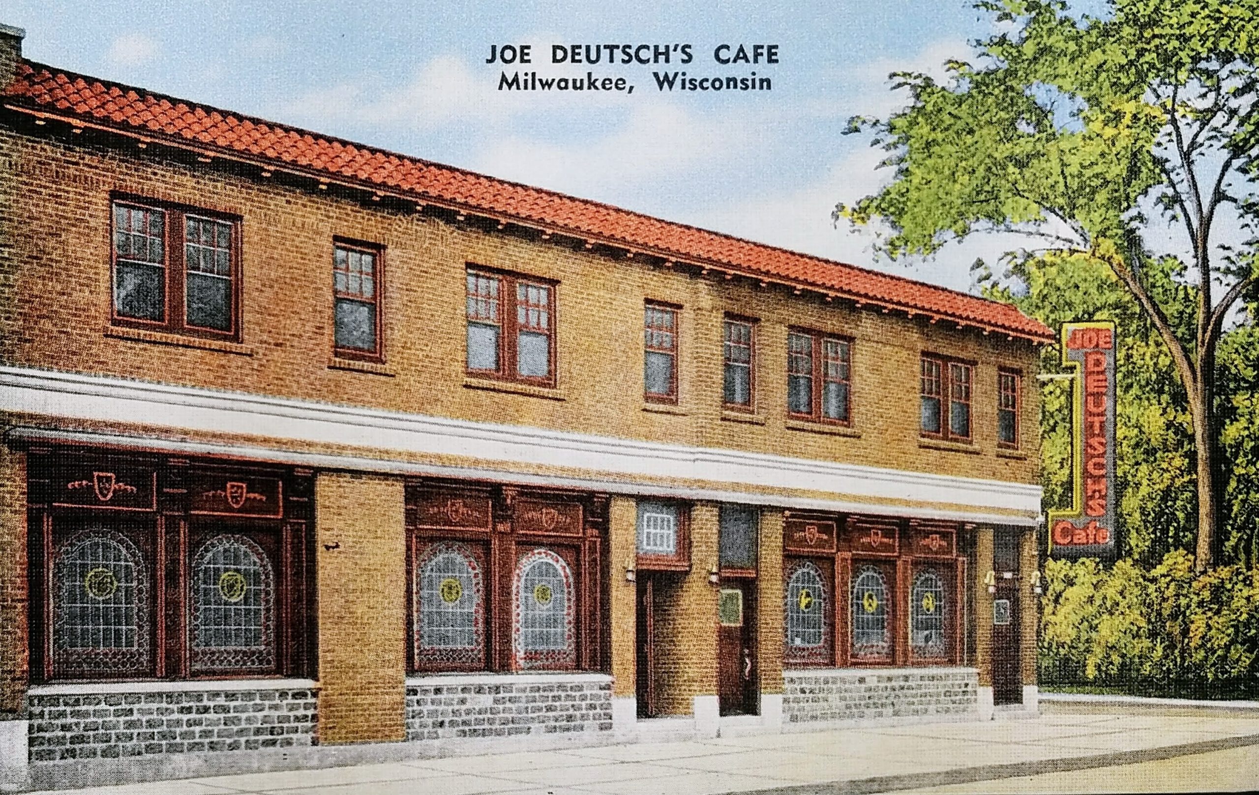
This postcard is not dated or postmarked. This card likely comes from the 1940s or 1950s. It gives the phone number of the restaurant as “Broadway 2-1922,” and the 2L-5N (two-letter, five-number) system for phone numbers began in the 1940s and was phased out starting in 1958. (Ever wonder why telephone dials and keypads have letters over each letter? Now you know! It’s leftover from this mid-20th-Century system of dialing.)
The address for Joe Deutsch’s was 1219 W. Galena St. The place closed in 1954, the building was razed between 1963 and 1971, and this block of Galena Street no longer exists. At one time, Fond Du Lac ran south only to Walnut Street, but in the 1980s, it was extended south into downtown. Today, this spot would be in the middle of the southbound lane of Fond Du Lac as it passes under 12th Street.
Joe Deutsch was a native of Austria, came to Milwaukee in 1912, and began working as a waiter in restaurants. He was employed at the Ogden Cafe and took over the restaurant in 1924 when the owner, Marie Heiser, died. Deutsch sold the Ogden Cafe to John Ernst in 1938. (John Ernst Cafe continued to operate until 2001.) In 1939, Deutsch opened the cafe on Galena and expanded it in 1949, but he closed five years later, in 1954, due to a slump in sales. This place had been popular as a spot for business and labor luncheons and dinners due to its many private dining rooms.
Joe Deutsch didn’t give up. In 1957, he opened the Capitol Lounge in the brand new Capitol Court shopping center. It was the first tavern licensed to operate in a Milwaukee shopping center. In 1958, he opened a new place with his chef, Howard H. Graun, called Deutsch & Graun at 340 West Kilbourn, where Major Goolsby’s is today. In 1966, Graun passed away, and the restaurant became known as Joe Deutsch’s. He leased the space from the Journal Company, and it was known as the city’s second Press Club. In 1970, he sold the business to a company headed by Al McGuire, Marquette’s basketball coach, which was interested in directing it more toward sports fan appeal.
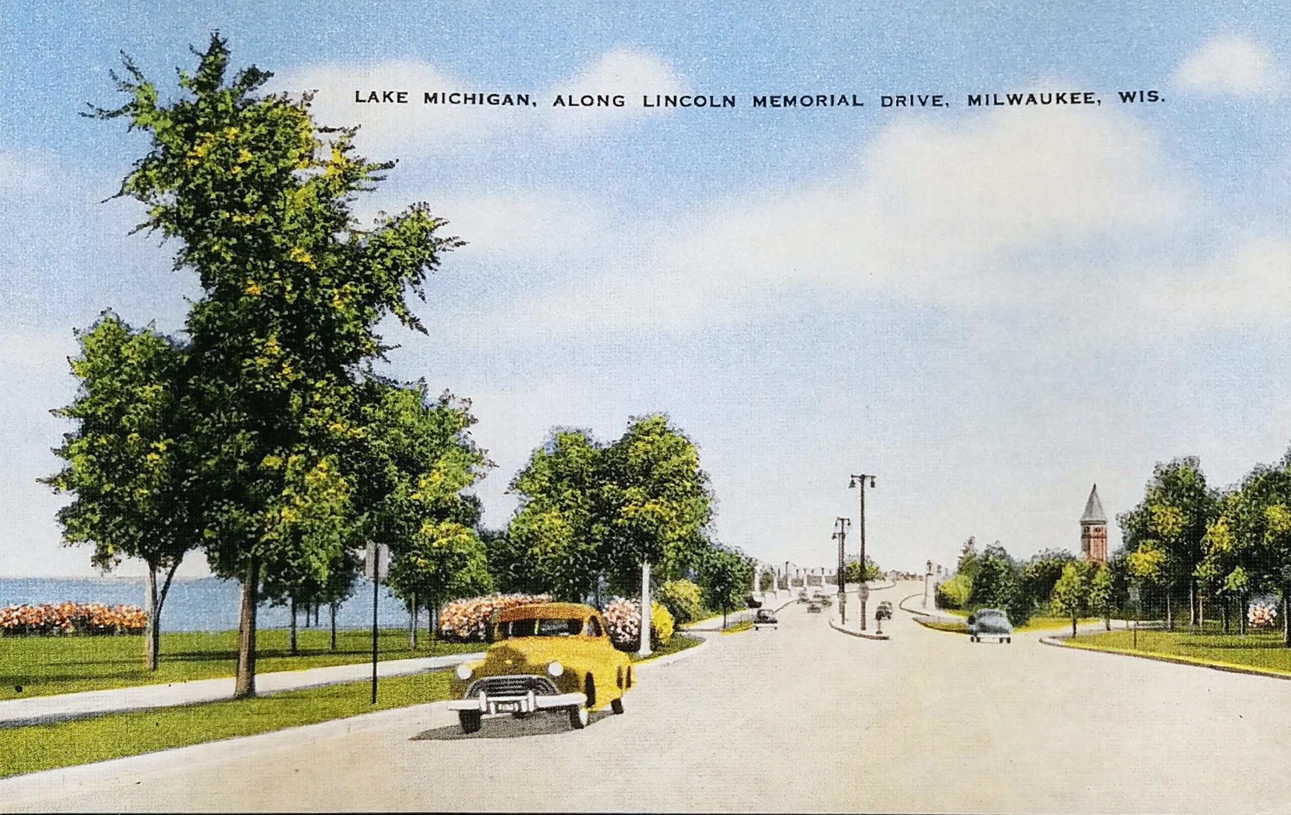
This undated postcard must come from around 1950. I’m no automobile expert, but based on the unique grill, that looks like a late 40s Oldsmobile on the left.
Lincoln Memorial Drive opened in 1929. You can see the Lake Front Depot (peeking above the trees) which came down in 1968. And you’ll note that the Eero Saarinen-designed War Memorial building is missing; that opened in 1957.
When Milwaukee was first settled, none of this was land. At the beginning of the 20th century, many city residents wishing to view Lake Michigan were limited to seeing it from either Juneau or Lake Parks. Mansions above the bluffs along N. Prospect Avenue blocked most of the vistas. Sunbathers and swimmers who wanted to go to the small beaches below the bluffs went via one of the parks. Reaching the water from Juneau Park required crossing four sets of railroad tracks.
City councilman wanted residents to have more access, so they secured from the state legislature permission to create a 300-foot-wide strip of lake bed along the shoreline between Juneau and Lake Parks in the 1890s. Between 1917 and 1937, Milwaukee filled in over 77 acres of submerged land to create the downtown lakefront.
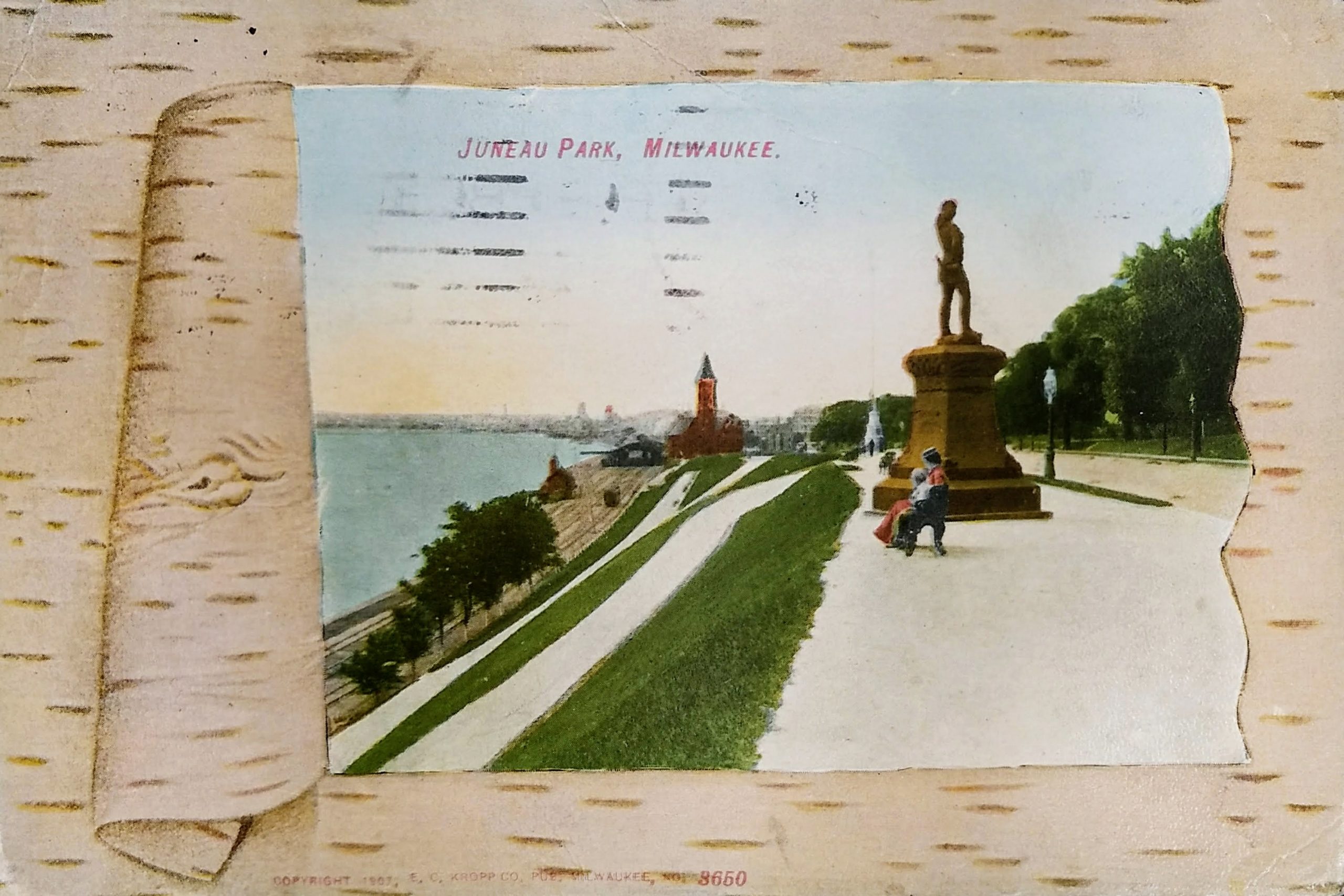
This old postcard is postmarked 1909. It shows Juneau Park, and although much has changed about the park and lakefront, you can see a couple of familiar things.
In the foreground is the statue Leif, the Discoverer, which still stands today in Juneau Park. The original was unveiled in Boston on October 29, 1887. This replica was erected in Milwaukee two weeks later.
Beyond that, barely visible, is the Juneau Monument. You can see its white base most clearly against the green trees. The sculpture was unveiled on July 6, 1887, by Solomon Juneau’s granddaughter, Hattie White.
The monument commemorates one of Milwaukee’s founders, Solomon Juneau. He settled an area east of the Milwaukee River in 1818. His home and trading post were located where the 100 East Wisconsin Building now stands. He named his settlement Juneau Town. He later joined with George H. Walker’s Walker’s Point and Byron Kilbourn’s Kilbourntown (present-day Westown) to incorporate the City of Milwaukee. Juneau was the postmaster and the first president of the Village of Milwaukee and was elected the first mayor of the City of Milwaukee in 1846. In 1854, Juneau and his family relocated to Dodge County, Wisconsin, where they founded the village of Theresa, named after Juneau’s French-Canadian mother. Solomon died one year later in Keshena, Wisconsin, on a visit to the Menominee tribe.
Of course, there was no Lincoln Memorial Parkway until decades later. By state law, the city had the right to a 300-foot-wide strip of lake bed along the shoreline. In 1907, the massive landfill project that took more than 20 years to complete was started. The work created McKinley and Bradford Beaches as well as a lagoon and a small park around it. Lincoln Memorial Drive connected them all and ran from E. Mason Street to E. Kenwood Boulevard, a distance of slightly over three miles. It opened in 1929 and was named for Abraham Lincoln, whose statue stands in front of the War Memorial today.
In this image, you see Chicago & Northwestern Railroad tracks and, in the distance, the old Chicago & Northwestern Railway Depot on Wisconsin Avenue. This building was razed in 1966.
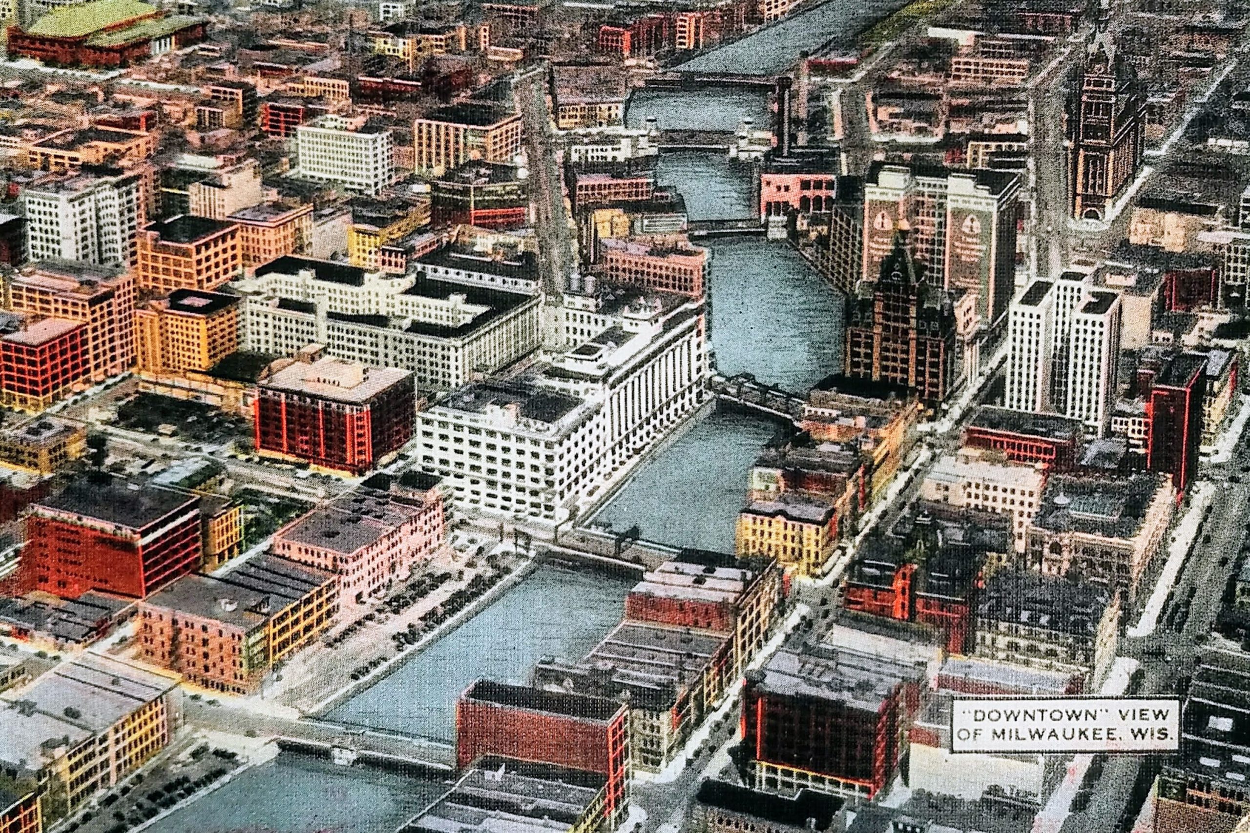
Here is a great, undated postcard of Milwaukee from the air. You can see many of downtown’s oldest buildings here. This view is from the 1930s or 1940s. The postcard contains the Centre Building (barely visible near 2nd and Wisconsin), which was built in 1931, but is missing the two-story Art Moderne parking garage Gimbels constructed in 1947 on the corner of Michigan and Plankinton.
On the top right is the City Hall (1895 to present).
Below and to the left of City Hall (with two large vertical signs) is the First Wisconsin National Bank Building (1914 to present). Below that is the distinctive Pabst Building (1892 to 1981). To the east (right) of the Pabst, the tall, white building with two wings is the Bankers Building, constructed in 1929 and still standing today as the Drury Plaza Hotel. South of the Pabst, along the east (right) side of the river, is a block of small buildings that were razed between 1959 to 1961 to make way for the Marine Bank building, including the Mack Block Building, National Exchange Bank, and Bradley Building.
On the right side of the postcard, midway from top to bottom, you can see a tall, thin, red building–that’s the Railway Exchange Building that still stands on Broadway and Wisconsin. Just south of the Railway Exchange building and north of Michigan Street is the Loyalty Building, built in 1886 as the second headquarters of Northwestern Mutual Life.
To the south of that, across Michigan (and right above label “‘Downtown’ View of Milwaukee, Wis.”) is the Chamber of Commerce Building or Mackie Building. You can see its distinctive tower. The ornate building was built in 1880 and still stands. To the left of that, the red building is the Mitchell Building (1878 to present).
A block south of that, to the left of the postcard label, is the Button Block building on Clybourn (once known as Huron St). It was built in 1892 and still stands today. It has had a number of clubs and restaurants on the first floor, from Park Avenue to Brett Favre’s Steakhouse. Today, it is the Homewood Suites.
Across the river you can see the buildings that comprised Gimbels–the northern part along Wisconsin Avenue built in 1923 and the southern portion along Michigan Avenue in 1920. Both still stand today. Peeking over Gimbels, on the north side of Wisconsin between Plankinton and the river, you can see the Empire Building, built in 1928. That still exists and houses the Riverside Theater.
The large, white, block-long building to the west (left) of Gimbels is the Plankinton Arcade. This is how it looked after 1925, when an additional five floors were added to the original two-story building. In the same block, south of the Plankinton Arcade, you can see two buildings that no longer exist. On the corner of Michigan And Plankinton, the large, red, eight-story building is the Plankinton Hotel (1917 to 1980). (I actually got to see a portion of this come down while visiting downtown with my folks.) And along 2nd Street, to the north of the surface parking lot, is the 11-story Hotel Antlers.
A block north of the Plankinton Arcade, you can see eight-story, five-sided Brumder Building or Germania Building. It has a bit of an odd shape to match the block it’s on and features four distinctive covered domes in the shape of Kaiser helmets on its roof. It was originally named the Germania Building, but they changed the name during WWII in honor of the owner, George Brumder (and to obscure the German reference). That was built in 1896 and still stands today.
Above the Germania Building, you can see another building that still stands today. The reddish/brown, nine-story Chalet At The River Building. It was built as a six-story building in 1908, and the top three floors added in 1913. To the left of that is a white building called the Century Building. It was built in 1925 and had Radio Doctors on the first floor from 1961 to 1991.
And, finally, in far upper left corner, you see the Milwaukee Auditorium (now known as the Miller High Life Theatre.) In 1950, the Milwaukee Arena would be built to the east of the Auditorium.
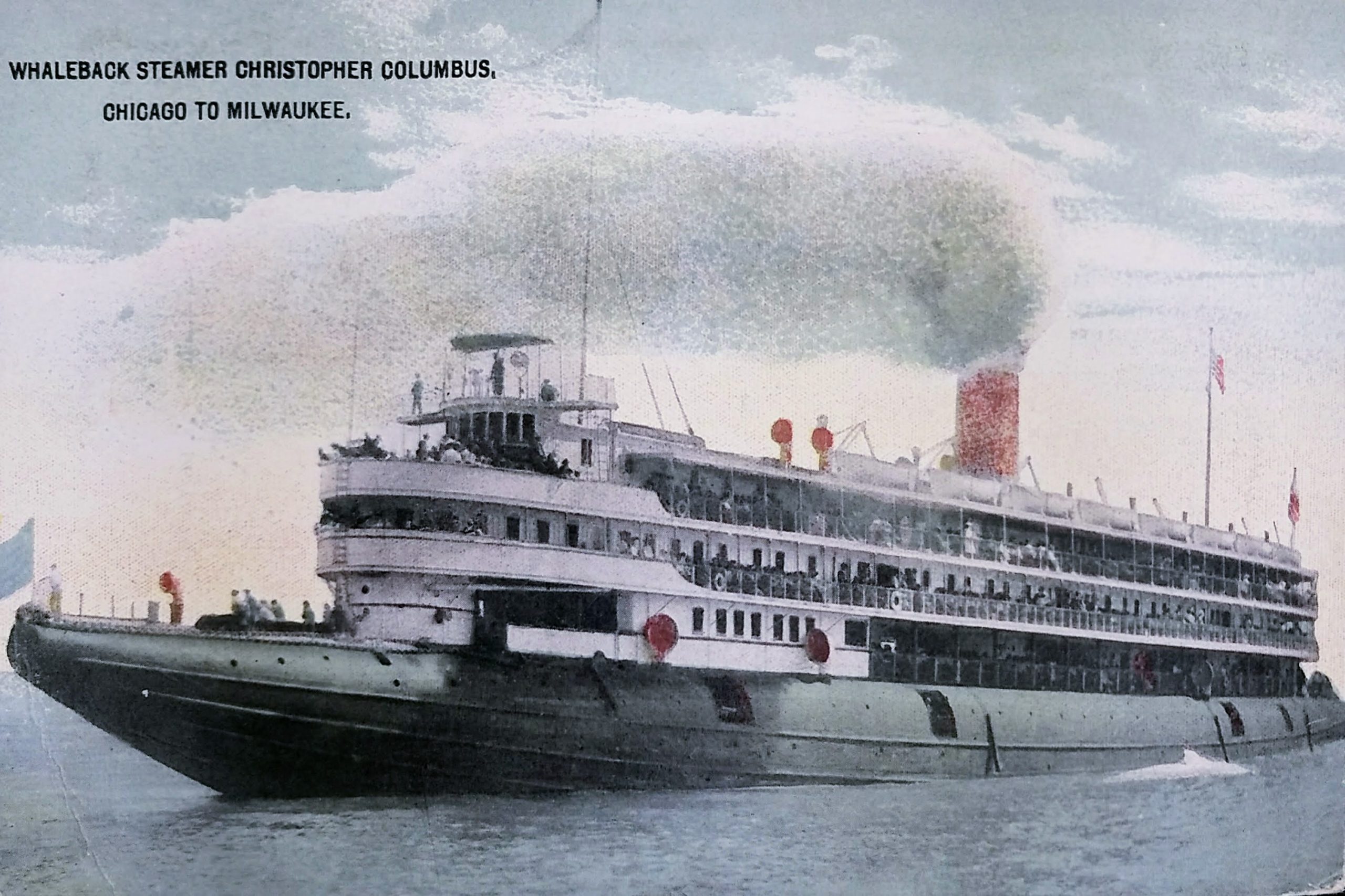
This is not a Milwaukee building, but it’s interesting nonetheless. This undated postcard shows the Christopher Columbus whaleback steamer. SS Christopher Columbus was the only whaleback ship ever built for passenger service, the longest whaleback ever built (at 362 feet), and reportedly also the largest vessel on the Great Lakes when she was launched.
The World’s Fair Steamship Company ordered the boat to ferry passengers to the Columbia Exposition (hence the name of the boat.) She was elegantly furnished. Her grand saloon and skylighted promenade deck contained several fountains and a large aquarium filled with trout and other fish of the lakes. The cabins and public spaces were fitted out with oak paneling, velvet carpets, etched glass windows, leather furniture, and marble. Shops and restaurants were provided for the passengers.
The ship was built for speed, making the six-mile run from Chicago’s downtown to the Jackson Park site of the Exposition in under 20 minutes. She had an estimated capacity of 4,000–5,000 passengers on her four decks, but it was reported that she carried 7,000 on her maiden voyage. The Columbus carried between 1.7 and 2.0 million passengers during the exposition, with only one fatality, a crew member. After the exposition ended the Columbus entered passenger service.
The boat had at least four accidents. In June 1895, on just the second day of its summer ferry season, the Christopher Columbus suffered an explosion caused by a steam pipe becoming disconnected while she was underway, enveloping the ship in a cloud of blistering steam. The accident happened, it was reported, while racing with a rival ship, the Virginia of the Goodrich Line, from Milwaukee to Chicago, although its captain denied the claim. Thirteen people were injured.
In 1896, she struck the Buffalo Street swing bridge in Milwaukee. Swing bridges open by spinning horizontally from a pier in the middle of the river. The bridge was three-quarters open and had 75 people on it to watch the boat pass when the accident happened. The bridge was displaced three feet, and had it moved another six inches, it would have fallen into the river. The City attempted to stop the boat from navigating so far upriver but eventually realized it didn’t have the authority because the river was under control of the war department.
In June 1905, as the Christopher Columbus was being towed out of the Chicago River, she collided with the schooner Ralph Campbell. It suffered no damage.
And in 1917, the boat had its most serious accident. Recent floods made the Milwaukee River unusual treacherous, causing the ship to collide with a water tower. The tower topped and flooded the Columbus’ decks with about 25,000 gallons of water. The collision killed 15, 16 or 18 passengers, by various accounts. Milwaukee police estimated 20,000 Milwaukeeans flocked to the river the following day to watch “the grewsome search for bodies.”
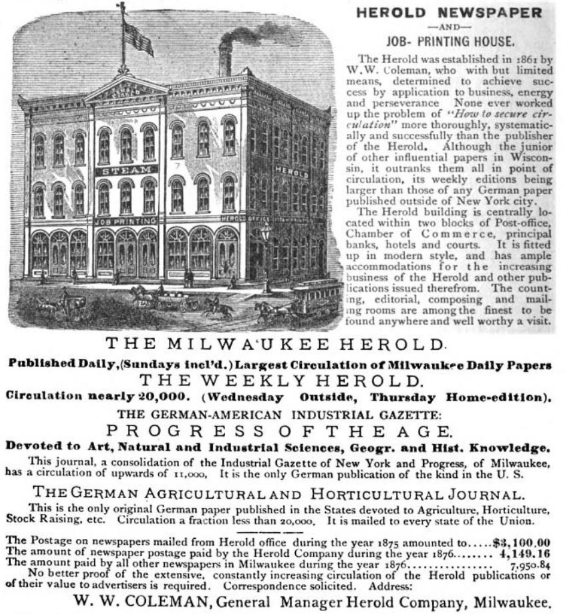 On the far right, the four-story building with the two curved awnings at street level is the
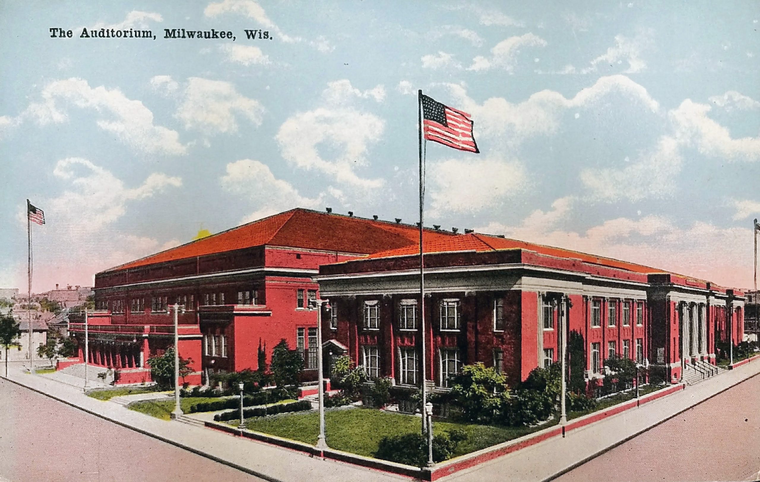